Saturday, June 28, 2008

DVP Stormwater Mgmt Project


Some of the maps of the project area at the open house

Two weeks ago I attended an open house for a new Class Environmental Assessment that the city has launched for the lower Don Valley. The project will look into various options to manage runoff from the Don Valley Parkway. The open house itself was pretty low-key. I counted only about two dozen attendees at most. Some people were expecting a presentation followed by a Q&A but there were only display boards available to look at with some staff on hand to answer questions. Presumably, there will be a presentation when the consultants have have studied the issue and reported back to the city.

The open house encouraged people to fill out a comment sheet on the project (The commenting period ends July 4 so if you're want to put your 2 cents worth in you need to send it in soon). I decided to post my comments here as well as a few handy maps to guide you. There were three major sites and several smaller enhancements being looked at. I will look at each one in turn.


Todmorden Mills (aka Site 75)

This site already has three sizable ponds and associated wet areas. These are fed by springs that occur at the base of the slope throughout the forest. The ponds are all well established and functioning well. My comments to the project:

Very little modification should be performed on the existing pond. The wetland is performing nicely as habitat for wetland plants and animals of all kinds. Any work to deepen or widen the existing pond will significantly damage or impair its current biological function.

Stormwater management at this site should be targeted toward new treatment ponds, specifically a new pond located in the vacant cloverleaf located just south of the existing pond. Stormwater can go through primary treatment here before it is allowed to drain into the existing system of wetland ponds.

While a “Do Nothing” approach means that there will be no improvement in water quality, it should be noted that water quality is already high.


Site 83

This site is a sliver of the valley that was orphaned when the DVP was built. My comments:

This is a remote site that is cutoff from the rest of the valley. It has little current value and is rife with non-native invasive species. Either a wet pond or a constructed wetland are suitable here. A wetland may be better since it won't require on-going maintenance that a wet pond would require.


Site 132/135

This site is entirely within the cloverleaf that makes up part of the offramps from the DVP to Don Mills Rd. These isolated areas make them ideal for stormwater management. An old wetland was created here some time ago. My comments:

Both of these locations are relatively large so it may be possible to combine some wet pond and wetland functions on both sites with one leading into the other. If this isn't possible then either type is suitable. There is an existing wetland in the northern site. This could be enhanced as a wetland but its function shouldn't be impaired by trying to turn it into a wet pond.

Minor Sites

These are a collection of small sites that are downslope from existing outfalls that issue between the southbound DVP lanes and the Don River. My comments:

Care should be taken to ensure that any embayments be constructed so as to minimize loss of existing trees and shrubs. The location of the Enbridge natural gas pipeline needs to be ascertained prior to any design proposals as it runs through many of the minor sites being studied.

Monday, June 23, 2008

The Don, Flooding Again


Railroad bridge, at end of Beechwood Drive

Same bridge when river is not in flood

Torrential rains across the city Monday afternoon drenched the city. Whenever the city gets this much rain in a short period (I was caught by the rain just as I was leaving a pub. I had to stay an extra hour... darn!) it always impacts the Don more so than other areas. There are still many storm sewer pipes that flow unrestricted into the river. All the rain that hits our roads and parking lots ends up in the river. This effect is amplified because a lot of water is funnelled into a narrow channel, ie. the Don River. If you compare the two pictures above, you can see the level of the water is nearly 2 metres above the normal water level.

I took a short bike ride through the lower Don and took a few more pictures.


Mud Creek, north of the Brick Works. Normally a small creek, it becomes quite a torrent after a storm. The fallen tree at the bottom left was washed out by a storm about a month ago.

Chester Springs Marsh with water. Normally it is dry except for these rare occasions when the water is high enough to flood the marsh basin. Damaged hydrology means that it will empty very quickly rather than retaining this moisture.

Lower Don Path at the Riverdale footbridge. I had to exit here because the path was completely flooded.

Another shot of the river in flood

Sunday, June 22, 2008

Other People's Posts

Once I finish with summer school I should post more frequently. Until then you'll have to be content with other people's stuff. On the Spacing blog is a recent story about a Weekend morning walk to the Brick Works.

Sunday, June 15, 2008

The Don Valley - History of Homelessness?

I came across an interesting link this week. It is an audio presentation given by a historian named Jennifer Bonnell. The presentation which lasts near 17 minutes is entitled Toronto's Underworld: The Don River Valley as a 'Repository for Undesirables'. The talk is given as an historical perspective of the Don Valley and its use by various people especially in the early part of the 20th century. In the 1910s the valley was used by itinerant groups of Roma (then referred to as gypsies). They made encampments near Eglinton Ave. East on the East Don and near Yonge and York Mills on the West Don.

In the early 1930s, groups of unemployed men made encampments on the flatlands just north of the viaduct. This encampment which numbered 300-400 was broken up by the province by simply hiring the lot to work on the Trans-Canada highway.

Bonnell makes a rather tenuous connection between the historical events and the present situation of scattered homeless encampments that dot the valley in and around the downtown ravines. I can't say that she made a good case for the Don Valley as a backwater area of Toronto - a place where garbage was dumped - both regular and human. Still the talk is interesting to listen to especially if you are a local history buff.

Friday, June 13, 2008

Don Mills LRT

I attended an open house on Monday in the cafeteria of the Rosedale Heights School of the Arts near Castle Frank subway station. I had to fight my way past the auditorium where a music concert was in progress to get to the sparsely attended transit gathering. This was the inaugural meeting for another Class Environmental Assessment on building an LRT along Don Mills Road.

I wasn't very impressed since it was basically a rehash of the last year's study concerning Don Mills Transit improvements. All they did was swap out the idea of high speed bus lanes and insert a dedicated LRT right of way. I much prefer trains to buses but the problem of how to get from Don Mills and Overlea to the Danforth still remains.

Steve Munro, a transit aficionado, has done a much better job of explaining these options so I recommend you read his posting on the subject. The only thing that I added to the discussion was an idea about reusing an old CPR rail line that exits the Don Valley at Redway Road. It might be possible to run an LRT along this line all the way down to Union Station. There is also possibilities of stops at the Brick Works, Queen Street East, and Cherry Street next to the Distillery District.

There are two major issues with this route, first it is only a single track and it would be very expensive to add a second track. Secondly, CPR wants to retain the line for a future GO connection to places north and east. When I mentioned this at the open house they said the second reason was a bigger stumbling block.However, I don't think this is a reason not to study the option. Part of the EA process is to look at all alternatives.

Regardless of what option the study recommends, it is unlikely that this will ever be built. It is part of the city's Transit City initiative which is dependent on getting bags of money from the Province and the Feds (as if that will ever happen).

If you're interested in seeing things for yourself there are two more public meetings in the next two weeks.

Thursday, June 12, 2008

Don Valley Parkway Stormwater Management

The city of Toronto has initiated a Class Environmental Assessment to study methods of managing stormwater runoff from the Don Valley Parkway and its adjacent catchment areas. The scope of the EA covers the DVP from Lakeshore Blvd. East to the Forks of the Don.

If you want to get involved there is a public meeting scheduled for Tuesday, June 17, 2008 from 7 - 9 PM at Todmorden Mills. Check out the city's website for more information.

Sunday, June 01, 2008

Garbage Cleanup Day


Two down, one to go

Saturday was the U of T Mountain Biking Team's annual Don Valley Cleanup day. Since its humble beginnings nine years ago, it has grown to encompass corporate sponsors, media coverage and tree plantings. The Task Force to Bring Back the Don was also there with pamphlets and information. I woke up to here David Wright's voice on CBC Radio's Fresh Air show give a little blurb about the morning activities. I am not sure if it resulted in more attendees but it certainly was pleasant to get some recognition for a Don Valley event.

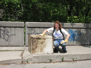
Last year I attended with a specific goal which was to remove an abandoned safe from the valley. It turned out to be a bigger job than I thought but I managed it with a little help from a friend. This past winter I located two more metal boxes and I resolved to extract them too. This time I brought some help with me. We used a wheelbarrow instead of a dolly and this worked out better. Even though the muscle power required to wrestle the loaded wheelbarrow along the trail was more than a dolly requires it was easier to manage the load on the trail's rough spots. We only managed to get one more out (the mosquitoes were swarming!). We decided to leave the last one for next year.

The weather held off for the most part and provided us with a good opportunity to remove another load of junk from the forested slopes. Here are a few pix from the morning's activities.


Norco, Kona, and Pedal Magazine were some of the event sponsors.

A BBQ provided some lunch for the volunteers

Garbage collected. The usual assortment - tires, shopping carts, old bicycles and a computer monitor.

The city provided a garbage truck to cart away the garbage. They had to make several trips.

There was a whole passel of swag to give away. I scored another t-shirt.