Showing posts with label Trails. Show all posts

Monday, May 06, 2013

New path for the Don Valley

The new trail looking north from Gerrard Street East

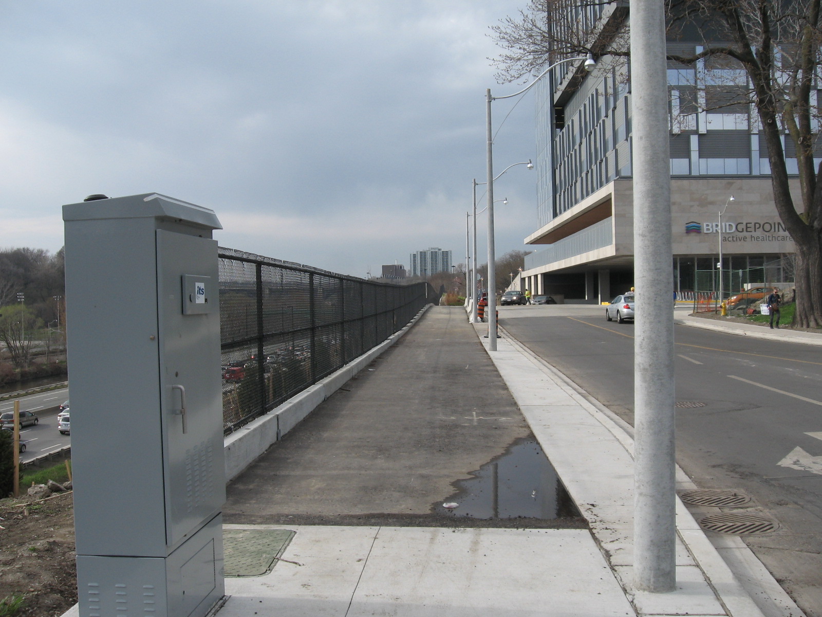
Now that the new Bridgepoint Health Hospital has opened up and landscaping is almost finished, a long promised connection along the west side of the property is now open for use. A new path has been established that runs between the new hospital building and the Don Valley Parkway. The path starts at Gerrard St. East at a new light just east of the bridge that crosses the DVP. The path starting at the NW corner of the intersection proceeds north along the edge of the fence and provides a new access point to Riverdale Park East. Currently the path just ends at the grass. The city has yet to build a connecting path so for now you'll have to traverse about 50m of grass and dirt before you get to the paved path that provides access to the park and the pedestrian bridge that connect to the west park and to the Lower Don Trail.

The path is an easier grade and is more convenient to park users who need to get to Gerrard Street and the local neighbourhood.

Please note that landscaping along the trail is not yet finished so the trail may be temporarily closed while work is being done. Official opening of the trail has not yet been announced but already people are using it so it should be OK for use most of the time.

The new trail at St. Matthews Road and Gerrard Street East, looking northwest


The trail is right next to the new hospital

Looking south along the trail. Note that the landscaping is not yet finished

The place where the trail enters Riverdale Park East

Thursday, January 10, 2013

E.T. Seton Bridge Project Status

E.T. Seton Bridge Project.


Map Legend
Green: open trails (not plowed)
Red: wooden ramp removed, access extremely limited
Black: approximate placement of temporary fences
Blue: informal detour (use at own risk)

I visited the bridge replacement project site at the south end of E.T. Seton Park. It looks like the construction company has abandoned the site for the winter. Some fences are still up but all is not lost. The bridge across the railway tracks is still usable and if you are coming from Don Mills and Overlea (Flemingdon Park) you can still access the bridge via a narrow set of stairs. However the access ramp from E.T. Seton has been removed and is impassible except for the most intrepid of hikers. Getting a bike through here is next to impossible. There is an alternative informal path but it involves crossing the CN tracks and I can't recommend that but it appears that some people are using it. So despite the signs and fencing there is currently limited access. 

I heard through councillor Jaye Robinson's office that a metal ramp will be installed late February, early March. It was my understanding that the Bailey bridge crossing the tracks would also be replaced. There is no word on when this will happen.


Project sign. The recommended detours are laughable at best. I doubt anybody bothers with them.

The bridge is still up. The former wide wooden stairs at the north end have been replaced by a set of narrow stone stairs. Not very bicycle friendly.

The old wooden ramp has been removed. Cement foundations have been put in place in preparation for a new ramp which has yet to be installed.
A look at the bridge with some interesting graffiti/art on the right.

Sunday, November 06, 2011

Getting to the Brick Works from Pottery Road


Three possible routes: red, green, and yellow (see below for descriptions)

The Don Valley Brick Works has undergone a transformation in recent years and has opened up under the care of Evergreen Canada as the Evergreen Brick Works. Evergreen has done a masterful job of restoring the buildings and updating the site for multiple uses including a farmer's market, a native plant nursery and a skating rink in the winter. The place is worth a visit.

Unfortunately access other than by car has been and continues to be a challenge. The TTC runs a bus there but only on Saturdays. The 28A Davisville bus extends its route to the Brick Works 8AM - 6 PM. Evergreen offers a shuttle bus from Broadview subway station that travels every 20 minutes between 7 AM to 7 PM (4:30 PM on weekends). Access routes by foot and by bicycle remain difficult and at times safety-challenged.

Improved intersection at Bayview Avenue includes a new pedestrian crossing on the north side

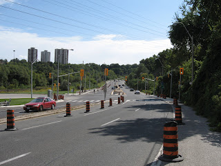
Recently the city has done a complete makeover of Pottery Road. It was supposed to re-open September 5 but due to issues with an unstable slope it remains closed until November 30. Fortunately, there is safe access for pedestrians and cyclists to make it through. In addition there is now a pedestrian crosswalk (with a crossing button on both sides) at the intersection of Pottery Rd and Bayview Ave so this is definitely a positive step forward.

Therefore it makes sense to review the access options to the Brick Works from Pottery Road. If you look at the map, there are three possible routes. Based on colours I will describe each route and their pros and cons.

Red Route


Path up side of hill. Ravine access road is just to the right (don't go that way)

From the intersection at Pottery and Bayview, cross at the lights and turn right (north). Go up the hill a short distance. When you reach a park access road that winds up through a small ravine to the north west, you will also see a dirt path going up the hill to your left. This path is very steep and can be slippery in wet conditions but can be managed with care. I don't recommend this route for any cyclists except those with good mountain bikes. At the top of the hill you will find a railway. It's OK - currently it is not in use and there are even small trees growing through the ties. Cross the tracks and scramble up a short steep embankment and this will bring you into the north east corner of the old quarry.


View of Brick Works ponds from the top of the slope

The top edge offers one of the best views of the quarry ponds. There is a dirt road which goes south and this will lead you to the north edge of the Brick Works complex. While going down the winding gravel road you will see a climbing tower built by Outward Bound, one of Evergreen's tenants. You can also take a detour to a lookout or scramble down the slope on one of the informal paths that lead into the pond area.

Green Route


Median is about 2m wide but only a painted line separates you from traffic. Be careful!

From the intersection at Pottery and Bayview, cross at the lights and turn left (south). Follow the paved median beside Bayview. This can be a bit unnerving because traffic comes up behind you at quite a clip. The speed limit on Bayview was recently reduced from 70 kph to 60 kph but this doesn't make you feel much safer. As you continue along around the corner you will notice a new access road that gets you into the back parking are of the Brick Works. At some point there will be Jersey barriers placed along this route but until then care must be used here. This is the shortest access route and is usable by both walkers and cyclists.

Yellow Route


Start of Yellow Route trail

This route starts immediately on the west side of the CN railway crossing. Getting to this point is the hardest part because you must cross two lanes of traffic with no aids other than your wits. When you cross the river, the only pedestrian access is on the north side so you need to cross the tracks and then scoot across the road (there has been talk of building a pedestrian bridge on the south side but this will be sometime in the future when gravy stops flowing down the Don River). Care must be used at this point. Once you make it across Pottery Road, this route turns out to be the nicest of the three.


Trail runs close to railroad so be careful

The informal path here follows a route between the railway tracks and the road. Safely ensconced between road and rail the path allows for mostly single file passage almost all the way to the entrance of the Brick Works. The path exits onto Bayview about 25m east of the lights. Fortunately a newly installed pedestrian activated button allows for easy crossing of Bayview. This route was recommended by me as the preferred route but unfortunately due to a point where it narrows near a rail installation, the city wouldn't go for it.

So there you have it. Recent changes make for easier access. Eventually the Green Route will be improved. Until then you can choose your preferred route based on your own comfort level.
Wednesday, October 26, 2011

Milkman's Lane Closed


Just north of Castlefrank Subway station is a secluded but well used path that provides a way down into the Don Valley. From the bottom of this path you can access the Don Valley Brick Works and the Belt Line path. How Milkman's Lane got its start is something of a mystery but local legend has it that when milk was still delivered to homes in the morning, this path provided a back entrance for milk carts for the tony neighbourhood of Rosedale.

Regardless of its origins, this well used access path is under severe stress. Whenever it rains, water sluices down the middle of the path creating deep furrows. This creates a hazard for both cyclists and pedestrians as they try to navigate the path.

This fall the city has decided to do some repair work. A new path will be constructed. When completed, the path will be raised in the middle with drainage ditches on the side to collect runoff. Cedar rail fencing will delineate the path but also limit dogs to the path to protect the fragile forest slope on either side of the path. In addition, informal paths that lace the nearby slopes will be closed off to allow for natural forest restoration.

The path is set to reopen, barring unforeseen delays due to weather or site problems, by mid-December 2011. For further information on this project see this page on the city's website.


Milkman's Lane


Rain runoff is creating deep gullies in path

Monday, September 26, 2011

Pottery Road Open (for Bikes)


Pottery Road closed at Broadview Avenue

A recent article in the Toronto Star highlighted the recent makeover of Pottery Road which apparently isn't going all that well. Apparently the slope behind a new retaining wall is unstable and they can't guarantee that it won't collapse so they've put the reopening on hold until they figure it out.

While the article said that car traffic is disrupted, they neglected to mention that the new bicycle/walking path is complete and fully available for use. A sign at the top of the hill says the path is closed but you can safely ignore it. The path which is separated from the road by jersey barriers is about 2m wide and fully paved. Caution is still warranted as the railing on the hill side hasn't been fully installed.

So too bad about cars but cyclists and hikers can rejoice!


Sidewalk sign says closed, use other sidewalk but there is no other sidewalk (hint: ignore sign)


Looking down the hill - brand new pavement


Looking up the hill. Retaining wall in question on the left


Wide path beside road. Todmorden Mills on the right, Fantasy Farm on the left


Expanded path underneath the DVP


New connection to Lower Don trail


Intersection at Bayview now includes a pedestrian crosswalk. The other side leads to an narrow paved median which can be used (with caution) to access the Brick Works.


Another view of the intersection at Bayview

Thursday, September 15, 2011

Leaside Spur I: Orphan Trail Needs Linkages

Map of the spur (the image is a little small. Click on it for larger image)
Legend:
  1. south end of the trail
  2. informal path and remnant track
  3. crossing at Lawrence Avenue East
  4. crossing at Tallwood Park
  5. crossing at Bond Road
  6. north end of trail
  7. York Mills Road
Starting just north of Eglinton Ave. East, just east of Leslie Street is a little known railpath which was once known as the Leaside spur. It starts just north of Eglinton, crosses Lawrence Ave. East and ends just south of York Mills. It once served the industrial area of south Don Mills and also served as an important cross link between the CP tracks to the south and the CN tracks to the north. In 2003 the city bought the right-of-way and turned into a walking trail. However, it is of little use as it starts and ends nowhere.

Up until now it has seen little use other than the occasional neighbourhood dog walker. But recently it has been resurrected as a possible part of the mayor's vision to create a city wide network of off-road trails.

A recent article in Grid TO prompted me to go take a look for myself. Here is what I found. From the southern start north to Bond Road the trail has been covered with a new layer of gravel, likely in preparation for a layer of asphalt. There are three places where it intersects with existing trails and circles of brick have been placed there to demarcate the crossing. At Lawrence Ave. East a new signalled crossing has been constructed although it is not yet in operation.
The new trail construction ends at Bond Road.

North of this point the trail continues but it is in the same state as the original walking trail. It is still covered in loose stone and cinder block that makes walking difficult let alone cycling. The trail ends again where it meets the CN main line just where it leaves the Don Valley on its way north to Richmond Hill.

There's more to this story than just these pictures. In a second installment I'll look at planned and proposed uses for this trail.


South end of trail (#1). Beyond fence is CP rail main line that crosses Eglinton Ave. East just east of Leslie St.


Informal trail leads to one of the properties on Leslie Street. The trail continues on the other side of the tracks


Just north of the informal trail you can see a remnant of an old spur (#2)


Last remaining track beside warehouse that is now used by Canadian Tire.


New crossing at Lawrence Ave. East under construction (#3)


Trail intersects with another path (#4) that leads to Talwood Park (to the west) and Duncairn Park (to the east)


New surfacing to end at Bond Road (#5)


Trail continues north of Bond Road. Note loose gravel surface that was hard to walk or ride on


North end of rail path (#6). Beyond is the CN rail main line


York Mills bridge across tracks can be seen to the north (#7)

Thursday, June 17, 2010

Path in Crothers' Woods


Path in Crothers' Woods

Since I've been too busy it seems to do much blogging, I thought I'd fill in some dead space with some pictures from my archives. This picture is from Crothers' Woods June 2009. I liked the foliage that has grown up beside the path which was built in 2008. Can anybody guess where this is?

Tuesday, October 13, 2009

New Trail in East Don


Trails in the East Don
Red = Existing trails
Green = Trail under construction
Yellow = Bridge locations

Since the summer the city has been busy creating a new trail in the East Don. The new trail will link a park known locally as Milne Hollow which is accessible from Lawrence Ave. East just east of the Don Valley Parkway and an unnamed park at the north end of the Wynford Park neighbourhood. So far they have completed clearing the trail (see green line). There is a plan to place a bridge at location #1 (see map) that will cross the river and create the link.


Sign detailing trail construction plans

What is not in the plan but makes sense to me is a similar link to Moccasin Trail Park. That trail would link to the southeast corner of the Don Mills neighbourhood which would be a easier access than through Milne Hollow which doesn't actually exit anywhere. So far there aren't any bridges crossing the river so you can't (legally) cross the river. I'll let you know when they do install a bridge which will make this trail much more usable.

The sign says that the eventual plan is to have the trail link up all the way south to the Forks of the Don although it may be a little tricky finding space south of Eglinton Ave. East since there is little wiggle room past the Flemingdon Park Golf Course. Here a few pix from the new trail.


Trail just south of Milne Hollow lined with limestone gravel

A little farther south the path lining changes to wood chips

The path as it goes under the CPR main line just north of Wynford Park

Sunday, March 22, 2009

Don Path Reroute


Bank erosion

Just south of the forks of the Don, the river runs through a relatively deserted section of the valley. Apart from a hydro corridor and the Leaside bridge there is not much to see other than the path and the river. This actually makes it a good place to view the river because there is nothing else to distract your attention. The path parallels the river and at times is right beside it. Unfortunately this causes problems when the river decides to do something like move its banks.


Erosion starting to cut into path

Last summer the river started cutting into the bank near a willow tree which was anchoring the bank. This cut became enlarged during a heavy rainstorm. The city put up a fence but it was obvious that the path would start to collapse into the river.


New path is to the left, the old path ran along the fencing. The asphalt has already been removed.

So early this spring a crew came in to close down the path next to the river and move it about 10m away. The detour is very smooth riding but you can't see the river as much in this section.


I took a short video while riding along the new section. Since the audio is not very interesting (wind and traffic noises) I found some 'riding' music and used that instead. The track is from SomaFM, an internet radio station that streams a variety of techno music. This track is from the stream called Groove Salad, one of my favourites.

Wednesday, November 26, 2008

Glendon Forest Trail Construction


Trail construction notification

Here's an item I've been keeping an eye on for the past couple of years. There was a section of the trail just south of Glendon Campus that was in bad shape. A narrow spot between a fence and the river, it was badly eroded due to overuse and ground water seepage. There was also drainage pipes spilling storm water into the river. All that has now been fixed. I went by in July and took some photos of the completed work. As you can see they have armoured the riverbank and placed a new and wider gravel trail on top. Hopefully the new trail withstands whatever flood the river can throw at it.


Trail in April, 2007

The river where outflow pipes loosely hang over the bank

July 2008: the new and improved trail

Before...

...and after

More pictures of Glendon Forest.