This was just released to the press:
Mayor Miller announces move to grow the Greenbelt in Toronto
Today, Mayor David Miller, Ministry of Municipal Affairs, Housing's Jim Bradley and Susan Houston of The Greenbelt Foundation, participated in an announcement of the City's intention to have the Don and Humber River Valleys designated as part of the Greenbelt.
"I can think of no more fitting way to celebrate the fifth anniversary of Ontario's Greenbelt than to have the Don and Humber Rivers become part of it. Torontonians are keen environmentalists and want to see our precious natural resources preserved," said Mayor Miller. "The future addition of these two valleys as requested by City Council would mean all three of our cherished river systems will be protected for generations to come."
This announcement signals the first step in designating the Don and Humber River Valleys are part of this permanently protected natural resource. If accepted by the provincial government after a review process, the Don and Humber River Valleys will join the Rouge River Valley as part of Toronto's additions to the Greenbelt.
"Ontario will continue to support efforts to curb urban sprawl by protecting our valuable farmland, countryside, water resources and wetlands, said Jim Bradley, Minister of Municipal Affairs and Housing. "On the fifth anniversary of Ontario's incredible Greenbelt, Toronto's decision to pursue Greenbelt expansion is a great step in the right direction."
Ontario's Greenbelt protects 1.8 million acres of environmentally sensitive and agricultural land around the Greater Golden Horseshoe, including the Oak Ridges Moraine and Niagara Escarpment, from urban development.
Here is a link to the staff report on the proposal.
Friday, February 26, 2010
Friday, February 19, 2010
Icy Rock Face on the Don River
Just north of Pottery Road, the Don River takes a wide bending turn around an old snow dump site. The site is cutoff from the rest of the valley by a CN rail line. If you happen to venture underneath the CN bridge you will come across this interesting site. On the south side of the river a bare rock face is visible at the bottom of a steep hill. Ground water emerging from between layers of shale has frozen into a cascade of ice that drops down to the edge of the river. The effect is quite stunning and makes for a beautiful addition to the rather drab appearance of the rest of the valley in winter.

Ice covered rock wall on banks of the Don River

Large icicles formed by water coming from between layers of shale

Another view of the icy splendour

Ice covered rock wall on banks of the Don River

Large icicles formed by water coming from between layers of shale

Another view of the icy splendour
Monday, February 15, 2010
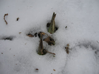
First Sign of Spring

Two Skunk Cabbage (Symplocarpus foetidus) sprouts poking their way through the snow
I visited Todmorden Mills today and noticed that Skunk Cabbage was starting to push through the thin layer of snow. This is one of the harbingers of spring!
Saturday, February 06, 2010
Things in the Don


Along the same lines as Places in the Don... here's a puzzle. Where are these and what might they be?
Subscribe to:
Posts (Atom)