Ever wanted to see what it's like to ride the Don Valley biking trails? Here's your chance. The bikers are having fun with helmet mounted videocams. I like this video the best. He goes over bridges and under overhangs. Another video is just straight trail riding with only one teeter-totter.
The state of the biking trails will be a future article for the Don Watcher.
Sunday, November 27, 2005

Thursday, November 24, 2005
Evergreen Open House
At some point in the next two years, Evergreen plans to start renovations at the Brick Works. Depending on how much money they get during their fundraising drive the impact could be moderate to large. At any rate things will definitely be changing at the Brick Works sometime in the near future.
They are making an effort at being open and inclusive as to their plans. Along these lines they are holding an open house next week on Tuesday November 29 and Thursday December 1st at the downtown YMCA. If you want to put your 2¢ in, now's your chance. Here is a PDF that has all the event information.
They are making an effort at being open and inclusive as to their plans. Along these lines they are holding an open house next week on Tuesday November 29 and Thursday December 1st at the downtown YMCA. If you want to put your 2¢ in, now's your chance. Here is a PDF that has all the event information.
Monday, November 21, 2005
N 43° 41.160 W 079° 22.120
Latitude and Longitude are plotted in terms of degrees, minutes, and seconds. This location happens to be in the vicinity of the Don Valley Brick Works. Why is this exact location significant? Because it is the location of a geocache. Geocaching is a worldwide treasure hunt game. It utilizes the global positioning satellite (GPS) system setup by the US military during the cold war. In the year 2000, they allowed access to the general public. Shortly afterwards geocaching was invented.
To play it you need a GPS locator device (see picture). These devices are moderately expensive ranging from $100-300 per unit. My Explorist 100 is near the lower end. When you turn it on it immediately starts to search for satellites overhead. This process takes about two minutes. Once a position has been fixed, it displays the latitude and longitude and constantly updates it as you move around. Depending on the unit it can be accurate to about 3 metres.
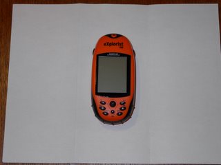
GPS Locator device
In the geocaching game you can be either a Cacher or a Seeker. If you are a Cacher, you obtain a small container such as a plastic Tupperware container that is water proof and place in it a logbook, a pencil, and a collection of small trinkets - just like a treasure chest! You then place this anywhere you like, in the city, in a park, or out in the country. With your GPS locator you determine its location. You then post this information on the geocache website. You can make it easy or hard to find.
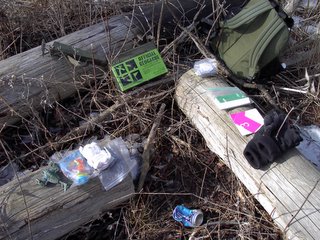
Contents of another Don Valley cache. This one is contained in a modified ammo box, specially sold by the Geocache suppliers.
Being a Seeker is the best part of the game. You go to the website and note down locations of caches in your area and then go out and try to find them. Uncovering a geocache is always enjoyable, it's like opening up a present under the Christmas tree.
When you find the cache, you open the container. You're supposed to write your name and date in the logbook. You can take one of the trinkets as a memento of your find. Some people also put more stuff back into the container so the contents are always changing. However nothing valuable is ever stored in a cache. We took a fridge magnet and left a breath mint.
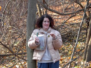
My friend holds the container and our loot!
We also took a geocoin (in her left hand). This is a special geocache item. Each coin is individually numbered. The first person puts it into a cache. Someone else retrieves it and then moves it to another cache somewhere else. You then post a separate log of this on the geocoin website and then you can see where this coin has been. Some coins travel all around the world. This coin, number 3007 has moved around the Toronto area and once to Algonquin Park.
There are over 100 geocaches in the Toronto area and about a dozen in the Lower Don. It took me a couple of tries to find the Brick Works cache because it located in a area of deep undergrowth. At some point I will become a cacher and place them in interesting places in the valley.
To play it you need a GPS locator device (see picture). These devices are moderately expensive ranging from $100-300 per unit. My Explorist 100 is near the lower end. When you turn it on it immediately starts to search for satellites overhead. This process takes about two minutes. Once a position has been fixed, it displays the latitude and longitude and constantly updates it as you move around. Depending on the unit it can be accurate to about 3 metres.

GPS Locator device
In the geocaching game you can be either a Cacher or a Seeker. If you are a Cacher, you obtain a small container such as a plastic Tupperware container that is water proof and place in it a logbook, a pencil, and a collection of small trinkets - just like a treasure chest! You then place this anywhere you like, in the city, in a park, or out in the country. With your GPS locator you determine its location. You then post this information on the geocache website. You can make it easy or hard to find.

Contents of another Don Valley cache. This one is contained in a modified ammo box, specially sold by the Geocache suppliers.
Being a Seeker is the best part of the game. You go to the website and note down locations of caches in your area and then go out and try to find them. Uncovering a geocache is always enjoyable, it's like opening up a present under the Christmas tree.
When you find the cache, you open the container. You're supposed to write your name and date in the logbook. You can take one of the trinkets as a memento of your find. Some people also put more stuff back into the container so the contents are always changing. However nothing valuable is ever stored in a cache. We took a fridge magnet and left a breath mint.

My friend holds the container and our loot!
We also took a geocoin (in her left hand). This is a special geocache item. Each coin is individually numbered. The first person puts it into a cache. Someone else retrieves it and then moves it to another cache somewhere else. You then post a separate log of this on the geocoin website and then you can see where this coin has been. Some coins travel all around the world. This coin, number 3007 has moved around the Toronto area and once to Algonquin Park.
There are over 100 geocaches in the Toronto area and about a dozen in the Lower Don. It took me a couple of tries to find the Brick Works cache because it located in a area of deep undergrowth. At some point I will become a cacher and place them in interesting places in the valley.
Sunday, November 20, 2005
The Salted Don
We've just had our official first stay-on-the-ground snowfall this winter and out came the bags of salt. Yes, it got kind of slippery on Friday night but do we really need mountains made of road salt to stop us from slipping? It's amazing that this is the first reaction people have: it's snowing, I'd better throw some salt on it. I hate road salt. When it's a snowy or slushy day I can just imagine it eating though my pant cuffs and my boots. The evidence is there at the end of the day when your red pants (or black or brown or whatever colour) have turned completely white at the bottom.
And quite frankly, it doesn't help all that much. Dumping a pile of salt in front of your house or in front of a store will melt the ice briefly but then, if you don't do something about it once it's melted, the pile of slush and salt will freeze up again.
When all those salt trucks go out on a run in bad weather, you can see the salt just flying off. And that salt, mixed with run-off water eventually ends up in our rivers. On a snowy day, watch the spray come off the roads from the DVP. It's quite stunning how much goes over the wall right into the Don Valley and ultimately ends up in the river. What concentration of salt would it take to turn the Don River into a salt water body?
Use something else! Put a little bit of elbow grease into things and shovel the snow off the sidewalk. Use sand and give folks a little grit. It'll make your pants dirty but won't eat away at them. You're better off in the long run. Just stop using salt.
And what is that salt stuff that's blue? That's scary stuff!
And quite frankly, it doesn't help all that much. Dumping a pile of salt in front of your house or in front of a store will melt the ice briefly but then, if you don't do something about it once it's melted, the pile of slush and salt will freeze up again.
When all those salt trucks go out on a run in bad weather, you can see the salt just flying off. And that salt, mixed with run-off water eventually ends up in our rivers. On a snowy day, watch the spray come off the roads from the DVP. It's quite stunning how much goes over the wall right into the Don Valley and ultimately ends up in the river. What concentration of salt would it take to turn the Don River into a salt water body?
Use something else! Put a little bit of elbow grease into things and shovel the snow off the sidewalk. Use sand and give folks a little grit. It'll make your pants dirty but won't eat away at them. You're better off in the long run. Just stop using salt.
And what is that salt stuff that's blue? That's scary stuff!
Friday, November 18, 2005
Keating Channel
This is part of an occasional series on interesting places along the Don River.
The Keating Channel is a rather dreary place but it is significant for the Don because this is where the river ends up. Located in the northeast corner of Toronto harbour, it still retains part of its industrial heritage.
It was built in the early part of the century as part of the project to fill in a lakeside marsh that stretched from Cherry St to Leslie St. It runs east from the harbour for about 800m before it ends at a sharp turn north where the Don River begins. It used to extend eastward all the way to Leslie St. but this eastward extension was filled in during the 1930's.
Today it is flanked by the elevated Gardiner Expressway and Lakeshore Blvd. East on the north side. The south side is shared by a city harbour works yard and the Keating Channel Pub. At the west end Cherry St. crosses the channel over a little used lift bridge.

The Keating Channel, looking east. In the foreground is an old Task Force planting site. The Gardiner Expressway is on the left. The dredger and the works yard are on the right. The smokestack in the distance belongs to the inactive city recycling incinerator.
It's impact on the Don is varied. Both sides of the channel are lined with concrete dock wall which creates a forbidding barrier and provides little habitat for fish and other water dwelling creatures. The Don is home to about 21 species (pg. 19) of fish. Only about four or five species can be found near the mouth. This is partly due to poor water quality but also due to lack of habitat. The dock wall continues, mostly unbroken all the way to the Riverdale Park section. In contrast the Humber River which does have a natural mouth is home to about 44 species.
Once water from the river flows into the channel it is basically in the lake because it is level with the harbour. Due to the low flow situation all the silt carried by the river is deposited in the channel. This makes it convenient for the conservation authority (TRCA) to dredge the silt. Currently they dredge about 35,000 cubic metres of sediment from the channel every year. The dredgeate material is barged out the Leslie Street spit where it is dumped in a containment area specially built for this purpose. The spit containment area has the capacity to take 50 years of Don River dredgeate.

Dredger at work. When the barge is full it will be towed to the Leslie Street Spit where its load will be dumped.
Another problem affecting the channel is floating debris that is washed down the Don. Mostly logs and dead wood, there is also an assortment of garbage that collects in the channel. The TRCA corrals this stuff with a boom across the channel. There can be quite a bit of flotsam especially after a big storm.
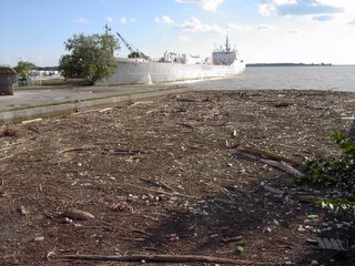
Debris leftover from the Aug. 2005 storm. A boom keeps the debris from entering the harbour.
Not all of the channel is in bad shape. On the north side of the channel a slight bend in Lakeshore Drive created an open space. The Task Force (and partners) decided to plant this area in the late 1990's. That was one of the first plantings I did in 1998. I still remember what terrible conditions it was for digging. Just below the sod was a mass of ash and brick with very little soil. We planted Staghorn Sumac (Rhus typhina) Peachleaf Willow (Salix amygdaloides) and Red-osier Dogwood (Cornus stolonifera). Only a few of the dogwood and willow still survive but the hardy sumac has thrived. These days it looks like a long narrow glade of small trees and shrubs, a small oasis amongst the blight of concrete and asphalt.
It is difficult to say what future there is for the Keating Channel. The channel as well as adjacent properties are the subject of an environmental assessment (EA) which aims to naturalize the mouth of the Don. It could remain the way it is now, it could be filled in or it could become part of a network of canals throughout the portlands. All of these are options being studied in the EA process.
Regardless of its ultimate fate, the channel remains a small but important part of Toronto's history.
The Keating Channel is a rather dreary place but it is significant for the Don because this is where the river ends up. Located in the northeast corner of Toronto harbour, it still retains part of its industrial heritage.
It was built in the early part of the century as part of the project to fill in a lakeside marsh that stretched from Cherry St to Leslie St. It runs east from the harbour for about 800m before it ends at a sharp turn north where the Don River begins. It used to extend eastward all the way to Leslie St. but this eastward extension was filled in during the 1930's.
Today it is flanked by the elevated Gardiner Expressway and Lakeshore Blvd. East on the north side. The south side is shared by a city harbour works yard and the Keating Channel Pub. At the west end Cherry St. crosses the channel over a little used lift bridge.
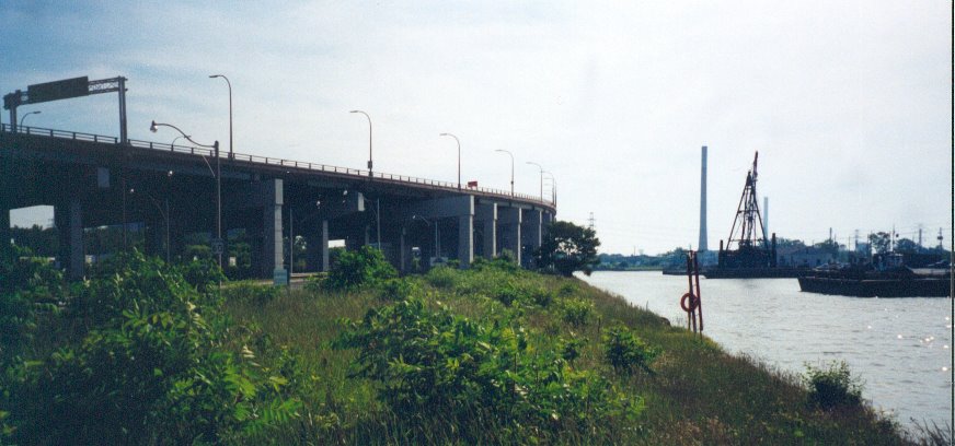
The Keating Channel, looking east. In the foreground is an old Task Force planting site. The Gardiner Expressway is on the left. The dredger and the works yard are on the right. The smokestack in the distance belongs to the inactive city recycling incinerator.
It's impact on the Don is varied. Both sides of the channel are lined with concrete dock wall which creates a forbidding barrier and provides little habitat for fish and other water dwelling creatures. The Don is home to about 21 species (pg. 19) of fish. Only about four or five species can be found near the mouth. This is partly due to poor water quality but also due to lack of habitat. The dock wall continues, mostly unbroken all the way to the Riverdale Park section. In contrast the Humber River which does have a natural mouth is home to about 44 species.
Once water from the river flows into the channel it is basically in the lake because it is level with the harbour. Due to the low flow situation all the silt carried by the river is deposited in the channel. This makes it convenient for the conservation authority (TRCA) to dredge the silt. Currently they dredge about 35,000 cubic metres of sediment from the channel every year. The dredgeate material is barged out the Leslie Street spit where it is dumped in a containment area specially built for this purpose. The spit containment area has the capacity to take 50 years of Don River dredgeate.
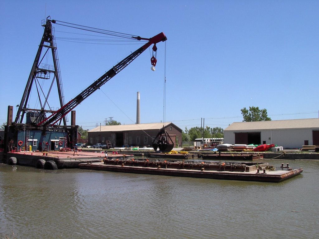
Dredger at work. When the barge is full it will be towed to the Leslie Street Spit where its load will be dumped.
Another problem affecting the channel is floating debris that is washed down the Don. Mostly logs and dead wood, there is also an assortment of garbage that collects in the channel. The TRCA corrals this stuff with a boom across the channel. There can be quite a bit of flotsam especially after a big storm.

Debris leftover from the Aug. 2005 storm. A boom keeps the debris from entering the harbour.
Not all of the channel is in bad shape. On the north side of the channel a slight bend in Lakeshore Drive created an open space. The Task Force (and partners) decided to plant this area in the late 1990's. That was one of the first plantings I did in 1998. I still remember what terrible conditions it was for digging. Just below the sod was a mass of ash and brick with very little soil. We planted Staghorn Sumac (Rhus typhina) Peachleaf Willow (Salix amygdaloides) and Red-osier Dogwood (Cornus stolonifera). Only a few of the dogwood and willow still survive but the hardy sumac has thrived. These days it looks like a long narrow glade of small trees and shrubs, a small oasis amongst the blight of concrete and asphalt.
It is difficult to say what future there is for the Keating Channel. The channel as well as adjacent properties are the subject of an environmental assessment (EA) which aims to naturalize the mouth of the Don. It could remain the way it is now, it could be filled in or it could become part of a network of canals throughout the portlands. All of these are options being studied in the EA process.
Regardless of its ultimate fate, the channel remains a small but important part of Toronto's history.
Monday, November 14, 2005
Please Water our Trees: Roundtable Report
As I reported last week, the mayor's Beautiful City Roundtable made a presentation on street trees which also mentioned ravines. I thought it might be pertinent to the Don so I obtained a copy of the report.
However it talks mainly about street trees and makes only a passing reference to ravines. Janet Rosenberg, the author of the report, makes some valid points about the state of street trees. The need for watering is one that the Task Force has repeatedly made. This applies to new plantings for ravine and street trees. Newly planted trees need a steady amount of water in the first couple of years. If drought conditions occur like they have over the past 4-5 summers then we need to water our trees. If not then we have unsightly rows of dead trees on our streets and clumps of dead sticks in our ravines.
The trees we plant in the valley are done mostly by volunteers. If we let our trees wither and die after the initial planting that can only have a negative effect on our volunteers. They see this when they revisit the planting site. This could have a disheartening effect on their future volunteer activities. Watering is good for both the body (trees) and the mind (volunteers) .
However it talks mainly about street trees and makes only a passing reference to ravines. Janet Rosenberg, the author of the report, makes some valid points about the state of street trees. The need for watering is one that the Task Force has repeatedly made. This applies to new plantings for ravine and street trees. Newly planted trees need a steady amount of water in the first couple of years. If drought conditions occur like they have over the past 4-5 summers then we need to water our trees. If not then we have unsightly rows of dead trees on our streets and clumps of dead sticks in our ravines.
The trees we plant in the valley are done mostly by volunteers. If we let our trees wither and die after the initial planting that can only have a negative effect on our volunteers. They see this when they revisit the planting site. This could have a disheartening effect on their future volunteer activities. Watering is good for both the body (trees) and the mind (volunteers) .
Subscribe to:
Posts (Atom)
