Monday, August 16, 2010

Fuel Spill in the Don


Map of fuel tank location and nearby stormwater outlet on Don River

On Sunday a fuel spill occurred that emptied into the Don River. What happened was that a construction crew excavating behind a Staples depot on Vanderhoof Avenue uncovered a large fuel tank buried in the ground. No one knew it existed but local historians suspect that it was a leftover relic from the days when the site was used as an airfield. The Leaside Aerodrome closed in the 1930s but they left the tank buried in the ground, forgotten until now.

In the process of digging up the tank it was ruptured and the contents exposed to the air. It was scheduled to be pumped out on Monday but a torrential downpour on Sunday caused the fuel to flow out of the tank. The fuel emptied into a nearby sewer which quickly led to a storm sewer outlet on the Don River. Fortunately a passerby noticed the problem and the spill was quickly contained. Today as I was passing by I saw the cleanup efforts well underway.

Many people assume that the Don is polluted and they are right. It used to be that the problems came from industrial sources like this but those days are long gone and spills are few and far between. Most of the pollution comes from stormwater runoff. Whenever there is a big rainfall (like this weekend), the rain is quickly diverted into storm sewers which empty directly into the river. The rain picks up detritus from our roads and lawns. In addition, in the Lower Don sanitary sewage mixes with storm water and the combined effluent adds to the rainwater runoff.

If there is any benefit to this fuel spill it is that it highlights the connection between the sewer grate on your street and pollution in the Don River. Think about that next time you want to soap down your car in the driveway. Now you know where that soapy water will end up!


Backhoe lifting derelict fuel tank


Workers in Don River putting a boom in place to contain the spill


Closeup of the stormwater outlet. You can see some of the oily slick on top of the water.


Tanker trucks being used to vacuum up the oil

Wednesday, July 21, 2010

New Road for the Don


Access road under construction

If you've passed by the mouth of Taylor-Massey Creek recently you will have noticed a considerable amount of construction activity. In addition to the sewer project that is taking up part of the parking lot in Taylor Creek Park there is also another related project occurring on the north side of the creek. Toronto Water is busy blazing a new road up the East Don (see map). The purpose of this road is to allow them to access to maintenance wells so that they can access a sewer that runs through the East Don ravine. The sewer was built in the 1960s when the city was more concerned about building things than about natural spaces.

The sewer which is now about 50 years old requires some monitoring and possible maintenance. In order to inspect the sewer they need to lower a camera mounted on a robot into the sewer so they can look inside. The monitoring equipment and the robot are quite substantial thus a road is required to get it to the access grates.

The road is following the path of an old construction road laid down by the TRCA in 1999 so that they could do some slope remediation. The new road will go past the slope and extend another 400m east alongside the river.

Eventually the road will be used by Parks to establish a trail through the Charles Sauriol Preserve that will link up with parks further north such as Milne Hollow and Moccasin Trail.


Restored part of old construction road. New armour stone is on right, river is on the left


Another section showing riprap lining bank


Some of the construction vehicles parked in the staging area just north of Taylor-Massey Creek

Monday, July 19, 2010

First Resident of the Don


Groundhog spotted at Lakeshore Blvd. East and Don Roadway

I was going by the mouth of the river last week just where Lakeshore Blvd. East crosses the river at the Don Roadway. Immediately south of the bridge the Don River enters the Keating Channel. Just at the southwest corner of the intersection I spotted a groundhog (Marmota monax) coming out of a hole from underneath the bridge abutment.

There is a bit of debate whether the Don River ends here or whether the mouth is actually where the Keating Channel enters the harbour west of Cherry Street. The effects of the harbour and the lake water actually extends further up the channel to around Eastern Avenue. To my mind the Keating Channel right turn elbow demarcates the end of the river. Therefore this groundhog would be living in the place closest to the mouth of the river.

I've seen groundhogs in several places in the Don Valley. They are a pretty common species and have adapted to urban conditions. Groundhogs are herbivores so I guess the grassy roadside next to the Don Roadway makes for some pretty easy living. This one was pretty nonchalant and sat by his hole watching me for 10 minutes as I snapped several pictures. As I fiddled with my camera looking for the video setting, it scurried into its den so I only have a few still photos from the encounter.

Friday, July 02, 2010

Lower Don Sign II


Latest cleaning job gets rid of most graffiti

I am kind of ambivalent about interpretive signs in the Don these days. At first I thought these were a great idea. Educate the public, raise awareness about the natural environment, etc. Unfortunately not everyone is so high-minded. These signs have attracted an unusual amount of vandalism in the form of graffiti tags. Some of the signs have become so bad they are unreadable. The city does not have the resources to keep up with the maintenance and removal has been haphazard at best. The result is a sad collection of ugly signage in the Don.

The sign on the Lower Don Trail just north of the Riverdale Park footbridge has been the unlucky target for the worst of the tagging. After a couple of attempts at getting the city to clean it up and at least one time when I cleaned it myself, I have given up on this sign. That was 16 months ago. However, as I passed by it yesterday I noticed that it has been cleaned up once again. Most of the paint has been removed and the sign is now legible again (although you can still see it has been through the wars).

Sadly I expect this sign will be covered in another month with a new coating of graffiti. It may be time to rethink our signage strategy for the Lower Don.

Thursday, June 17, 2010

Path in Crothers' Woods


Path in Crothers' Woods

Since I've been too busy it seems to do much blogging, I thought I'd fill in some dead space with some pictures from my archives. This picture is from Crothers' Woods June 2009. I liked the foliage that has grown up beside the path which was built in 2008. Can anybody guess where this is?

Saturday, May 22, 2010

Spring Wildflowers

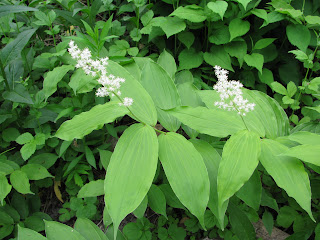
Here's a few pictures of wildflowers I have seen in the Don Valley this spring. All of the pictures except the Spring Beauties are from the Lower Don and neighbouring tributary ravines.


Canada Mayflower


Wild Sarsaparilla


Virginia Waterleaf
\

May Apple


Toothwort


Spring Beauties


Trout Lily


Wild Geranium


White and Purple Violet


False Solomon's Seal


Wild Coffee