Showing posts with label History. Show all posts

Monday, November 16, 2009

Celebrating a Dubious Anniversary


Poster announcing funeral for the Don River

40 years ago today a group of students from the University of Toronto held a mock funeral for the Don River. Organized by the then nascent Pollution Probe, between 100-200 people gathered underneath the Bloor Street viaduct on the east bank of the river to lament the state of the river.
"Dearly beloved, we are gathered here to mourn the passing of our late dear friend, the Don River",
intoned organizer Martin Daly. A woman dressed up as Lady Elizabeth Simcoe read exerpts from her diary which extolled the virtues of the Don as Toronto's main salmon stream. At the end of the service a wreath was tossed into the muddy waters of the river.


Photo from Toronto Star, November 18, 1969

The next day another 100 or so people gathered on the steps of Queen's Park and sang a requiem mass for the "dead Don River".

Oh, but the 1960s were great for colourful protests. So here we are 40 years later and I am trying to think of what has been accomplished to improve the state of the river. The bad news is that the river is still polluted and will likely remain so for the foreseeable future. In 2007, a provincial report listed the Don River as "Ontario's worst waterway". While the river's polluted state hasn't changed the nature of the pollution has. In 1969, eColi levels topped 61 million per 100 ml. These days those levels have been significantly reduced through a combination of sewage plant closures, a plan to capture sanitary sewer overflows, and a program to repair improper/illegal cross connections between sanitary and storm sewers.

In the late 19th century, the lower Don was heavily industrialized and effluent dumped into the river caused pollution in the Ashbridges Marsh which eventually resulted in the marsh being filled in to create the Portlands. Subsequent neglect of this area has resulted in most of it being turned into an indutrial wasteland of abandoned brownfields, but I digress. The industry is long gone and so has its pollution. Today's pollution is mainly due to runoff from roads, parking lots, and other hard surfaces. Whenever it rains the water quickly runs into the storm sewers and into the river. On its way the water picks up sand, grit, oil, salt, and whatever other urban residues are lying around. The river which often takes on a muddy hue after a rainstorm reflects this urban runoff. Annual dredging of the Keating Channel at the mouth of the river where all this runoff is deposited amounts to 35,000 m3 of material!

Solving this problem is no easy fix. The Don watershed is now over 80% urbanized and there's not much that can be done about that. The Don River flows through the world we live in. However the structure of our built environment can be modified. One such plan seeks to change how we design and build structures and also retrofit older buildings so that they have less of an impact on the watershed and the river. The TRCA has recently created the Don Watershed Plan which lays out planning and design methods that could lead to a better built city, one that has a lower impact on the environment. Implementing these methods requires changes in the way we think about development. While it may require more short term expenses, in the long term it will pay us back with a cleaner river.

On the face of it, this 40th anniversary isn't much to talk about. The river is still polluted but in the interim people who care about the Don have put in place a framework which could lead to an environment which will allow the river to flow a lot cleaner than it has for sometime. Who knows, maybe the Don will one day again be known as Toronto's best place to fish. I just hope I don't have to wait another 40 years to see it happen.

Thursday, May 28, 2009

St. Matthew's on the Move


St. Matthew's Lawn Bowling Club

One of the fixtures on Gerrard Street East next to the Don River will soon be no more. The St. Matthew's Lawn Bowling Club is slated to be moved to a new location just around the corner on Broadview Avenue. The move is part of the expansion plans of Bridgepoint Health which was renamed from the old Riverdale Hospital. Bridgepoint wants to build an underground garage where the club building sits now so rather than just demolish it, they decided to move it.


Building has been placed on platform of girders in preparation for move.

The lawn bowling club is a rather non-descript cottage-like building yet it turns out to have a rather storied past. Built in 1906, it is an example of the early 20th century architecture found in the Riverdale neighbourhood. The club lasted for 100 years but with the decline in interest of lawn bowling as a sport the club closed its doors in 2007.

Previously, the place where the building resides was used as a "House of Refuge". In the 19th century it was established as a place for poor and indigent people to receive medical treatment. They paid for their treatment with work. In 1870, a smallpox epidemic hit Toronto and the House of Refuge became a hospital to care for the sick. Over the next 130 years the place transitioned into the old Riverdale Hospital.

Riverdale Hospital got caught up in a binge of hospital restructuring in the 1990s. The result was Bridgepoint Health but that's another story. The real story is what occurred in our past which was rediscovered due to the relocation project. Since the club building was designated as an historic site the move required an archaeological review. The review revealed not only the archival history of the House of Refuge but also physical evidence on site in the form of pottery shards, bits of glass and other discarded objects.


Route to be taken to relocate the building

The relocation itself which is scheduled to happen this weekend, will see the building moved north through an existing parking lot, over a retaining wall and through Riverdale Park to its final resting place next to the southern park entrance on Broadview Avenue. The move necessitated the removal of 11 trees, mostly non-native Austrian Pine and Norway Maple. Once the move is finished these trees will be replaced by higher quality native species such as Red Oak, Silver Maple, and Trembling Aspen.


View of Riverdale Park East, looking north along the relocation path.

I don't have any information on what's happening with the building after the move but it would be nice to have it restored and turned into a local museum which could then showcase some of the history of the Riverdale's past. You can find more information about the project on the city's website.


Informational sign about project including picture of what the new location will look like.

Sunday, March 29, 2009

Podcast on Don River History

A new website has appeared called NICHE which stands for Network in Canadian History and Environment. In a nice twist the acronym is the same in French: Nouvelle Initiative Canadienne en Histoire de l'Environnement.

On the website are several projects including one entitled Nature's Past, a member project about the environmental history community and current research in Canada. The first podcast episode released December 10, 2008 was about the Don River. It is 45 minutes long and features an interview with Jennifer Bonnell, a PhD candidate at the University of Toronto who is writing her thesis on the environmental history of the Don River. For anyone who is interested in local Toronto history it is certainly very interesting. It shows how early Toronto history was closely intertwined with the Don River and its valley.

The project has released three more podcasts on a variety of Canadian stories related to environmental history. When I have some time I will certainly check out the rest of the website which is rich in content. Episode 1 is about 41 Mb which is certainly small enough for most portable listening devices. Enjoy!

Thursday, February 26, 2009

Historic Ice Jam Pictures


Taking care of ice on the tracks just north of the Queen Street bridge, c1910. Courtesy, Toronto Archives

The Drop Machine forum is used by the cycling community to exchange information about, well, cycling stuff. Anything under the sun about cycling. There is even a forum dedicated to the Don since this is a favourite place for them to do all sorts of cycling. Most of the posts are related to organizing rides or other events but there are occasional posts about other things.

One of them has recently delved into the Toronto Archives and dug out some historic photos of the Don River, circa 1907-10. These illustrate that in those days, the Don used to ice over. The resulting ice flows also created problems for the adjacent railway. Those days are long past as I discussed in my own recent post about the Don in winter. Nonetheless, the pictures are interesting to look at.

The picture displayed above is looking south toward the Queen St. East bridge. If you look carefully, you can see a portion of the turret of the Don Station just underneath the bridge in the left background.

Wednesday, February 11, 2009

Historical Map of Crothers' Woods


Crothers' Woods area in 1880 (contemporary place names in red)

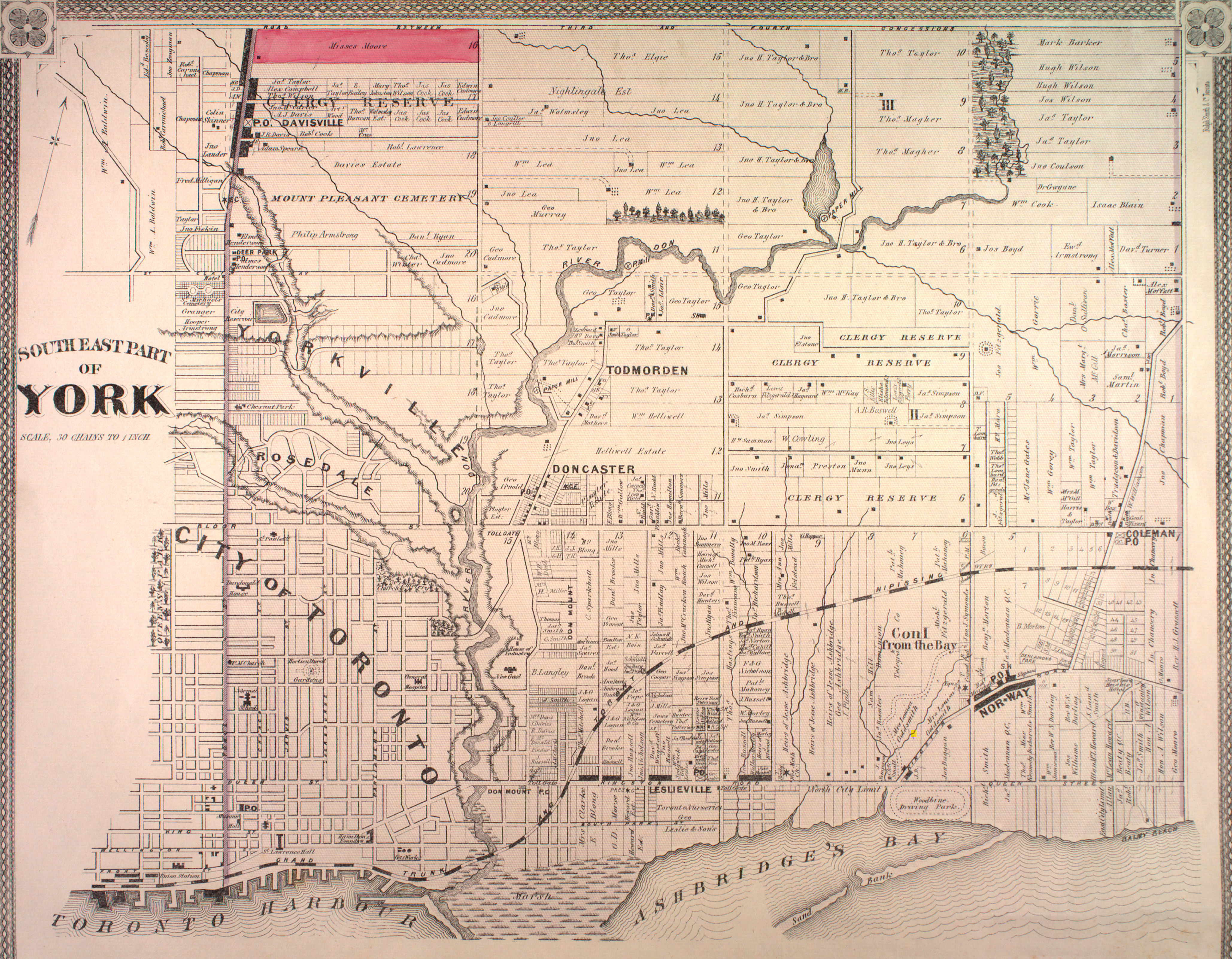
Historical maps are a fascinating subject. They reveal interesting facts about past land use and can show trends in development over the years. The map shown above is a fragment taken from a larger map of York Township in 1880 (warning: the full map is over 6Mb in size).

I cut out this fragment to show the Crothers' Woods area. I superimposed some of the contemporary uses and place names to give you an idea as to where it is. Apparently the Taylor brothers (who created the Don Valley Brick Works) were big landowners in this area. Maybe they should have named it Taylor's Woods.

If you're interested in maps of Toronto, a great new book has just been published called the Historical Atlas of Toronto. It is chock full of maps from several eras of Toronto. Well worth a look even for those with only a passing interest in history.

Wednesday, December 10, 2008

Don Station on the Move


Don Station being dismantled

I passed by Todmorden Mills this week and was surprised to see the Don Station in pieces, literally. It is being dismantled so that it can be relocated to a railway museum downtown at the Roundhouse. The station was relocated to this site about 40 years by Charles Sauriol when it was threatened with demolition. Originally located just south of the Queen Street bridge it was an active station for about 60 years.

Local legend has it that it was built to serve the Belt Line Railway but my railroad aficionado friends tell me that it was actually built in 1896 which was two years after the short lived Belt Line went bankrupt.

This relocation is part of a plan for Todmorden Mills first proposed about a year ago that also involves restoration of an old bridge and other site improvements.


Building sliced in two

Parts of roof ready for transport

Cupola on a separate trolley

The station building, spring of 2006. It's been boarded up for as long as I can remember. Once the move is complete, maybe it will get a much need renovation and be open for visitors

Friday, February 01, 2008

Black History and the Don River

The winter is always a period of slow activity for the Don so don't expect much action on this blog until late March. Now that February is here there is a sudden flurry of media activity because February is designated as Black History Month. Of course once March rolls around we won't here a peep about this subject until next year. I'm a little ambivalent about the designation, after all any day of the year is a good one to make history.

Even though I am fairly well versed in the history of the Don Valley, I was surprised to find a connection between the river and "black history". About 130 years ago, George Brown, the well-known editor of the Globe, a forerunner of the Globe and Mail was travelling south on Don Mills when something spooked his horses and they bolted. He found himself tossed into the Don River. It just so happened that William Hubbard was nearby and witnessed the accident. Hubbard promptly jumped in and rescued Brown. Thus started a friendship between the two that led to Hubbard being elected to Toronto City Council.

Hubbard, the son of a former slave made his mark on council and served as an alderman for about 20 years off and on before retiring in 1915.

And that's pretty much all there is to it.

Tuesday, December 11, 2007

Charles Sauriol Article Contains Factual Errors

I came across an article in the East York-Riverdale Mirror written by Joe Cooper. It is entitled "The memory of Charles Sauriol must be preserved at Todmorden Mills". It talks about Sauriol, his Don River legacy and his connection with Todmorden Mills. Cooper wrote the article to emphasize his position that the Don Station now ensconced at Todmorden Mills should not be relocated to the Roundhouse down by the Skydome.

I am all for writing about history but he makes some important factual errors that I think are worth correcting. Last year I wrote Wikipedia articles on Charles Sauriol and Todmorden Mills so I know a few things about these topics.

Here's a rundown on the mistakes.

1. Cooper states that Sauriol formed the Don Valley Conservation Authority. It is true that he formed an environment group in 1949. However, it was called the Don Valley Conservation Association. The Don Valley Conservation Authority was formed in 1946 by the province through the Conversation Authorities Act. They have the same initials so it can be confusing.

2. Cooper claims that Sauriol's cottage in the valley was demolished due to the building of the Don Valley Parkway in 1961. In compensation he was made a member of Metro Toronto and Region Conservation Authority (MTRCA). Sauriol actually joined the Don Valley Conservation Authority as a board member in 1954. In 1957 it was merged with other local conservation authorities to become the MTRCA (now the TRCA). Sauriol retained his cottage until 1968. Part of his 40 hectares was expropriated for the construction of the DVP but he stayed on his land for a further seven years.

3. The Don Station was located at Queen Street further south in the Don. In 1969 CN decided to add another track to the Don line and the station was in the way. Sauriol raised some funds locally to relocate the station to Todmorden Mills. As far as I know the TRCA had nothing to do with it. The station itself has no connection to East York. I think Sauriol placed it at Todmorden Mills because it was convenient to do so. Cooper also wrote an earlier article about the Don Station on July 26, 2007. He stated that the Belt Line Railway went through Todmorden Mills. As far as I know Todmorden Mills has had only road connections. It has never been serviced by railroad and has never had any kind of railway depot or station.

Cooper also got a few dates wrong concerning True Davidson, mayor of East York but they are minor. Cooper's main contention is that the Don Station is closely tied to East York heritage and should remain at Todmorden Mills. If you know your history you'll realize that the station has little to do with East York. Its only connection is that it has been located at Todmorden Mills for nearly 40 years. Clearly it is part of Toronto's railway heritage. If the Roundhouse is ever restored as a railway museum than this is where it should be located.

Saturday, November 24, 2007

Luminous Veil Promoter Honoured


Plaque in memory of Al Birney

A couple of months ago the city mounted a plaque on the Bloor Viaduct. The plaque is located on the north side of the bridge at the east end. The plaque is in honour of Al Birney who was in large part responsible for the Luminous Veil, the suicide barrier that now adorns both sides of the bridge.

The barrier became necessary as the bridge became notorious as a convenient place for people who wanted to end their lives. Between 1919 when the viaduct was opened until 2003 about 400 people jumped from the bridge. The placement of the barrier has effectively ended this practice.

Inside Toronto wrote an article on Al Birney and the plaque mounting.


View of the viaduct, looking west. The Luminous Veil is shown above the railing and the plaque can be seen in the lower right of the photograph.

Saturday, August 18, 2007

History of CP Rail in the Don


Train crossing the railway bridge next to the Brick Works, c. 1935. The original four smoke stacks with the words Don-Valley-Brick-Works emblazoned are clearly visible. Only the "Valley" smokestack remains standing today. (click to expand the photo, it's kind of grainy)

I came across an article in a local history magazine called "CP Tracks". It is a publication of the Canadian Pacific Historical Association. The article is entitled "The Canadian Pacific Railway in Toronto's Don Valley". It details the history of railways in the Don, specifically on CP railroads. The article is quite fascinating, especially since I'm a secret railway buff. One of my contributions to Wikipedia was the article on the Belt Line Railway. I also wrote Wikipedia articles on the OA&PS, the NS&T, and the H&LBTC.

The author, Derek Boles, claims that the station house now residing at Todmorden Mills was not actually built for the Belt Line Railway. While the Belt Line did have a station at Queen Street, the actual building wasn't constructed until 1896, two years after the Belt Line Railway suspended operations. There are also several archival photos of train operations in the Don including the one above. I like this photo because it also shows the original four smokestacks at the Don Valley Brick Works.

If you're interested in reading the article, you can pick up a copy of the magazine at George's Trains, a local hobby shop on Mount Pleasant and Millwood. A fascinating store on its own - if you're a train lover you could get lost in there or worse yet, drop a couple of thousand dollars on equipment for your own train layout. Fortunately, I was able to extricate myself with only the magazine purchase.

Friday, September 29, 2006

Wonscotanach Watcher


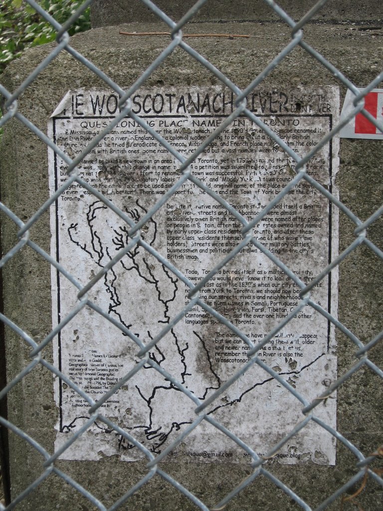
Poster seen on Lower Don Trail

No, I don't plan to change the name of this blog but there is at least one person who laments for the earlier names. Underneath the Riverdale Park footbridge on an old concrete abutment, someone has placed this rather bedraggled poster describing how the river lost its original native name the "Woscotonach". At the bottom is a barely legible signature but it points to another blog called the "Missing Plaque Project".

Wonscotonach or maybe Wonscoteonoch was first mentioned in Elizabeth Simcoe's diary. She said that it meant "black burnt land". This is possibly an Anishnawbe word. In 1788, Alexander Aitkin a surveyor created a map of the area and named the river Necheng qua kekonk. Lieutenant Governor John Graves Simcoe followed tradition and placed English names on everything of note. He named the Don River because the valley reminded him of a similar river in Yorkshire, England.

This blog is dedicated to producing historical plaques about forgotten events of Toronto history that the powers that be don't like to remember. Ever heard of the Christie Pits race riot? How about new city hall built on the razed rubble of Toronto's first Chinatown. You can view these posters in this archive.

It has been awhile since these names have been heard but I think the name Don is easy enough for most people so I think we are stuck with this name for awhile.

Monday, April 24, 2006

More Wiki

For those of you who are long time followers of this blog, you've probably noticed an overabundance of links to Wikipedia, the free online encyclopedia. That's mostly because I am also a volunteer Wikipedia editor. In my spare time I have been creating articles about the Don River. Since my last post I have added two new articles about Friends of the Don East and the Task Force to Bring Back the Don.

I created both articles. As with all Wikipedia content anyone is free to add or change the content. This is both a strength and a weakness. The advantage is that many contributors can add to each article creating a better piece of text. The disadvantage is that a malicious person can vandalize the text. Overall I think the pluses outweigh the minuses.

Read the articles yourself, and if you so desire you can add to them or change them (I tried to be accurate, but there could be something I got wrong or omitted). However, be warned - I've placed a watch on both articles so I'll know when something has changed.

Monday, March 06, 2006

Don River Wikipedia Articles

For anyone who is interested, I have created some new articles in Wikipedia, the free online encyclopedia. The articles are on Charles Sauriol, a noted Toronto naturalist and the Keating Channel at the mouth of the Don. Don Watcher regulars will probably recognize some of the Keating Channel content from an earlier blog posting.

Monday, January 02, 2006

Taylor-Massey Creek 'Wikified'

I have been neglecting Don Watcher for a bit but it's for a good cause. I have been working on some articles for Wikipedia. My latest effort has been to expand the article on Taylor-Massey Creek. The previous entry was pretty short.

Wikipedia is a different format than a blog. It's supposed to be an encyclopedia. One important concept they use is called neutral point of view or NPOV. This to prevent bias from influencing a reader. For example, I was updating an article on the Oak Ridges Moraine and referred to the Oak Ridges Moraine Land Trust that was preserving valuable habitat. Another editor came along after I finished and changed "valuable habitat" to "wildlife habitat" and said the word "valuable" was not NPOV - which is true. To a land developer I suppose it's worthless habitat.

So please go to Wikipedia and read my article - maybe even update it! I don't pretend to have the last word on TMC. This is the beauty of the Wikipedia concept. More than one person can contribute to the same article.

Thursday, December 29, 2005

Wiki Wiki

In addition to DonWatcher, I am also busy as a new editor of Wikipedia, the online, open source encyclopedia project. I am trying to update information on the Don River which is woefully lacking.

In the Wiki world I go by the username "Atrian" where you can view a short bio of me. I expect that there will be some duplication between DonWatcher and Wikipedia. I hope to post the best DonWatcher articles in Wikipedia. I have already added a Wiki article on the Belt Line Railway, which is basically the same text as in my previous post. I will also be posting the article on the Keating Channel. Future articles will no doubt make a double debut.

Wednesday, December 28, 2005

Belt Line Railway

This article is about a railway system that used to go though the Don Valley called the Belt Line. Part of a series on places in the Don. The previous article was on the Keating Channel.


The Belt Line Railway was built in 1890s. It was constructed as a commuter line to service new suburban neighbourhoods being built just north of the city. It ran through the communities of Rosedale, Moore Park, and Forest Hill.


The route started at Union Station going east to the Don River. It turned north following the river before journeying up a steep grade through the Moore Park Ravine beside the Don Valley Brick Works. It then turned west at the north edge of the Mount Pleasant Cemetery. At Yonge St. it turned northwest and travelled through Forest Hill before returning to Union Station via the CNR line at Caledonia and Eglinton Avenue West.


It started running in 1892 but only ran until 1894 before experiencing financial difficulties. It failed for two reasons. First it was expensive. The company charged 5 cents to travel between each station. In order to make more money they built more stations than necessary. Second, Canada experienced a financial depression in the 1890s. These two reasons led to the collapse of the commuter traffic.


However, there was sufficient business to run freight trains along the line, servicing lumber and coal yards along Merton Street. Freight service ended in the early 1960s.


After trains stopped operating the rail line sat unused for several years. In the Moore Park ravine section the tracks were pulled up and the railbed turned into a walking trail. In the late 1960s part of the right of way was expropriated to build the Spadina Expressway.


In the 1980s CN tried to sell the right of way for housing since the land was quite valuable. However a local city councillor, Kay Gardner, lobbied the city to buy the land for a pedestrian trail instead. This purchase was completed in 1990 and eventually the trail was named the Kay Gardner Beltline Park in her honour. It now forms part of a trail network called Discovery Walks.


The section between the Allen Road and Caledonia has either been sold off to local property owners or sits neglected and unused where it runs behind an industrial park. The only reminder of its existence are two bridges crossing Yonge St and Dufferin St. The Yonge St. bridge was incorporated into the beltline walking trail but the Dufferin bridge is derelict.


Most of the train stations were torn down. The only one that was saved from demolition was the Don Station which was located at the Don River and Queen Street East. When it was slated for destruction, local naturalist Charles Sauriol heard about it and persuaded the city to relocate it to Todmorden Mills. It now forms part of the heritage museum on Pottery Road.


Monday, December 26, 2005

Tales of the Don


Over the holidays I have become interested in finding out about Charles Sauriol. For the past 10 years, the TRCA and the Oak Ridges Moraine Land Trust have organized a fundraising event called the Charles Sauriol Environmental Dinner. I receive invitations but haven't attended. Nevertheless, the invitation sparked my interest in this guy, the original "Don Watcher".

Charles Sauriol was a naturalist and conservationist who grew up and lived in and around the Don for most of his life. He wrote six books about his memories of the Don of which "Tales of the Don" is one.

His books create a fascinating picture of the Don which was quite a different place 50 years ago. Before the 2nd World War it was still mostly untouched forest and hinterland. It's hard to imagine what it must have looked like without the Parkway and the Bayview Extension.

I was interested in finding out more about Sauriol but apparently no one has written a biography on him. I am currently collecting biographical details and some day soon hope to post a short biography.

If you are interested in reading his books, most of them are available at Toronto Public Library.