In addition to DonWatcher, I am also busy as a new editor of Wikipedia, the online, open source encyclopedia project. I am trying to update information on the Don River which is woefully lacking.
In the Wiki world I go by the username "Atrian" where you can view a short bio of me. I expect that there will be some duplication between DonWatcher and Wikipedia. I hope to post the best DonWatcher articles in Wikipedia. I have already added a Wiki article on the Belt Line Railway, which is basically the same text as in my previous post. I will also be posting the article on the Keating Channel. Future articles will no doubt make a double debut.
Thursday, December 29, 2005
Wednesday, December 28, 2005
Belt Line Railway
This article is about a railway system that used to go though the Don Valley called the Belt Line. Part of a series on places in the Don. The previous article was on the Keating Channel.
The Belt Line Railway was built in 1890s. It was constructed as a commuter line to service new suburban neighbourhoods being built just north of the city. It ran through the communities of Rosedale, Moore Park, and Forest Hill.
The route started at Union Station going east to the Don River. It turned north following the river before journeying up a steep grade through the Moore Park Ravine beside the Don Valley Brick Works. It then turned west at the north edge of the Mount Pleasant Cemetery. At Yonge St. it turned northwest and travelled through Forest Hill before returning to Union Station via the CNR line at Caledonia and Eglinton Avenue West.
It started running in 1892 but only ran until 1894 before experiencing financial difficulties. It failed for two reasons. First it was expensive. The company charged 5 cents to travel between each station. In order to make more money they built more stations than necessary. Second, Canada experienced a financial depression in the 1890s. These two reasons led to the collapse of the commuter traffic.
However, there was sufficient business to run freight trains along the line, servicing lumber and coal yards along Merton Street. Freight service ended in the early 1960s.
After trains stopped operating the rail line sat unused for several years. In the Moore Park ravine section the tracks were pulled up and the railbed turned into a walking trail. In the late 1960s part of the right of way was expropriated to build the Spadina Expressway.
In the 1980s CN tried to sell the right of way for housing since the land was quite valuable. However a local city councillor, Kay Gardner, lobbied the city to buy the land for a pedestrian trail instead. This purchase was completed in 1990 and eventually the trail was named the Kay Gardner Beltline Park in her honour. It now forms part of a trail network called Discovery Walks.
The section between the Allen Road and Caledonia has either been sold off to local property owners or sits neglected and unused where it runs behind an industrial park. The only reminder of its existence are two bridges crossing Yonge St and Dufferin St. The Yonge St. bridge was incorporated into the beltline walking trail but the Dufferin bridge is derelict.
Most of the train stations were torn down. The only one that was saved from demolition was the Don Station which was located at the Don River and Queen Street East. When it was slated for destruction, local naturalist Charles Sauriol heard about it and persuaded the city to relocate it to Todmorden Mills. It now forms part of the heritage museum on Pottery Road.
Monday, December 26, 2005
Tales of the Don

Over the holidays I have become interested in finding out about Charles Sauriol. For the past 10 years, the TRCA and the Oak Ridges Moraine Land Trust have organized a fundraising event called the Charles Sauriol Environmental Dinner. I receive invitations but haven't attended. Nevertheless, the invitation sparked my interest in this guy, the original "Don Watcher".
Charles Sauriol was a naturalist and conservationist who grew up and lived in and around the Don for most of his life. He wrote six books about his memories of the Don of which "Tales of the Don" is one.
His books create a fascinating picture of the Don which was quite a different place 50 years ago. Before the 2nd World War it was still mostly untouched forest and hinterland. It's hard to imagine what it must have looked like without the Parkway and the Bayview Extension.
I was interested in finding out more about Sauriol but apparently no one has written a biography on him. I am currently collecting biographical details and some day soon hope to post a short biography.
If you are interested in reading his books, most of them are available at Toronto Public Library.
Monday, December 19, 2005
Don Haiku
I just read an article in the Journal of Ecological Restoration that discusses the constant negative portrayal of environmental topics in the media. This has resulted in turning the general public away from the movement. The author says we should focus on positive and affirming terms like ecological restoration and stay away from fear based management of the issues.
I suppose I am just as guilty. Phrases like "Invasive Species", "Top Five Threats", "Keep Junk Out" have headlined several past postings.
Now I hope to reverse that trend. The valley is a place of wonder, no doubt. It's just something we take for granted. Does the answer lie in... poetry? Maybe it's worth a try. I don't claim to be a poet, but I've tried now and then. I will keep this one safe by using haiku, in the classic 5-7-5 syllable form. No title but it is seasonally themed.
winter valley sleeps
green turns white as night dawns grey
somnolence gathers
I offer you the chance to try your own. Submit your own poetry to Don Watcher: valley themed, any form.
Thursday, December 15, 2005
Wildflower Preserve Newsletter
Todmorden Mills is a Toronto heritage site on Pottery Road in the Don Valley. Near the front entrance are a number of buildings including an art gallery, a theatre, and a museum. The theatre is used by the East Side Players to perform amateur productions. Behind the buildings is a natural preserve which is managed by the Todmorden Mills Wildflower Preserve.
TMWP is a non-profit organization that maintains an interpretive trail and performs stewardship in the forest and in the wetlands. They produce a newsletter two times per year which they usually put up on their website. Unfortunately the webmaster found a teaching job in New Zealand and no one has been found to replace him so they haven't been updating it recently.
Therefore I am making the fall 2005 issue available until they get their act together. The newsletter is now available online in PDF format.
Monday, December 12, 2005
Top Five Threats: Infrastructure
This article is a continuation of the Top Five Threats story thread started last month.
The Don valley has the distinction of being the most central geographical feature in Toronto. Unfortunately this has produced a legacy of being the most frequent host for all the stuff the city doesn't want to move through its neighbourhoods, namely roads and railways. There are also pipelines, hydro-electric towers and sewers that lace the valley from the harbour up to Steeles. There is also 'soft' infrastructure in the form of two snow dump sites and city works yards. Let's not forget about the North Toronto Sewage Treatment Plant and the Police Dog Training Compound. Also some miscellaneous structures such as service roads, old landfill sites, weirs in the the river, culverts and concrete lined channels, etc.
Here's a summary of what the valley faces:
Don Valley Parkway: it enters the valley south of the 401 and except for a short respite at Eglinton it dominates the lower Don
Bayview Extension: enters the valley at the south end of Leaside it occupies most of the west side of the valley.
CN/CP railway lines: entering the valley near Eastern Ave, the railways don't exit until around Lawrence.
Enbridge gas pipeline: enters the valley at Bayview and Gerrard and continues north through most of the valley.
Transcontinental Oil Pipeline (TCPL): another pipeline runs underneath the valley but is currently decommissioned. They never removed the pipe so there's no guarantee that it won't be reused.
Hydro-electric corridor: a line of towers snakes north from the waterfront then veers east through the Taylor Massey Creek ravine.
Various sewers and city owned pipes: the valley is interlaced with a variety of storm and sanitary sewers, as well as some electrical conduits.
City infrastructure isn't so much a threat as it is an impediment. One of our priorities is to try and restore the valley to a more natural state. It becomes very difficult to do this if the available land is already occupied by roads and railways. For example, the section south of Riverdale Park is known as the 'Don Narrows'. Here the river is confined to a straight channel lined by steel and concrete embankments. It would be nice to try and restore some meanders which would renaturalize the banks of the river and help to slow down the water during peak flow periods. Unfortunately this is difficult to do because it is constrained by highways and railways on both sides.
Roads are also an impediment to wildlife. Now that deer are making there way into the Lower Don, they are finding out the hard way that roads are not the safest place to be.
If the above list is not bad enough the city is thinking of building yet another road in the valley. It is actually the last vestige of the Leslie Street extension, an obsolete plan that would have extended Leslie south to Bayview. Now it is called the Redway Road extension and is being proposed as a bus only road that would run from Millwood Road to Bayview. This is part of a larger plan to improve transit in the Don Valley Corridor. The Task Force views this as a Trojan Horse. Once it is built there will be serious pressure to open it to cars as well.
Faced with these obstacles the future of the valley looks pretty bleak. However things are changing, slowly, within the city. It is unlikely that any new infrastructure (aside from Redway Road) will ever be proposed for the valley. Also the Task Force has prodded the city into keeping an open mind about valley use alternatives. A recent report investigated alternatives to using the valley as a place to dump snow. While the Don may not benefit much by this new thinking it will certainly have a beneficial impact on Toronto's other river systems, namely, the Rouge, the Humber, and Highland Creek. Maybe we should rename the Task Force to Bring Back the Don to the Task Force to Bring Intelligent Planning to the City.
Tuesday, December 06, 2005
Please Keep Junk Out of the Valley
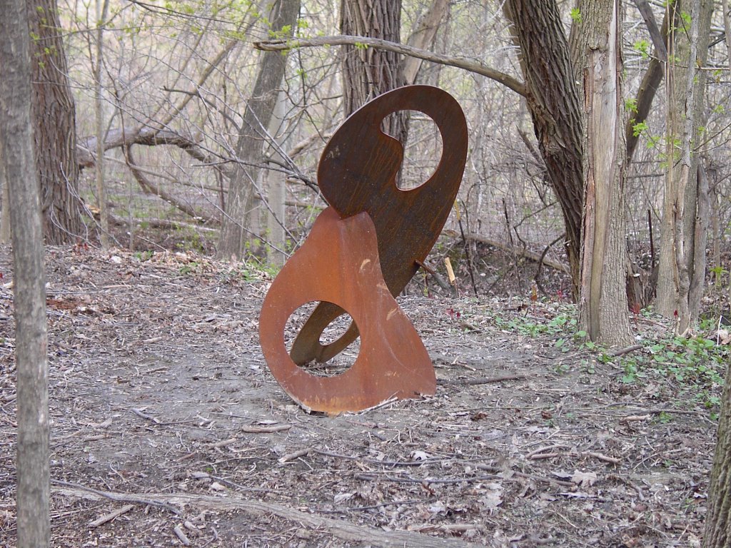
Art or Garbage?
This is another one of those appropriate use questions. This thing appeared in the Moore Park Ravine last spring. It is located beside Mud Creek just west of the Brick Works quarry ponds. The piece is obviously constructed and not a random piece of industrial refuse. It is made of some sort of metal about 1cm thick and stands about one metre in height. It is not signed nor is there any indication as to who created it or why is was placed here.
I contacted Sandra Lougheed, the city's curator of public art but she said there is no record of it. In other words, an anonymous person decided that they wanted to install this piece and chose this spot with no public consultation.
I admit to being an admirer of contemporary art and appreciate a well thought out sculpture. If you're looking for good examples of outdoor art you should visit Toronto's Sculpture Garden on King St. East just east of Church St. Opinions on contemporary sculpture vary widely but in my opinion this piece is pretty good. It is well balanced with clean lines and unpretentious.
That said, the thing that bugs me is that it is in the wrong place. The Don is already overburdened with the works of man, eg. highways, railroads, paths, pipelines, etc. The remaining area needs to be left to nature as much as possible, even in an area as degraded as the Moore Park Ravine.
So what should be done with it? At the very least it should be relocated out of the valley. I would suggest moving it to nearby Chorley Park. This is a large 'grass and trees' park in Rosedale and there are several places where it would fit right in. I asked the city if there was a policy on unofficial art installations but received no response. I don't know whether the city can actually 'adopt' it.
So if the city dithers long enough I might just load it into a wheelbarrow and truck it home. I think it would look good in my backyard.
Thursday, December 01, 2005
Slime Molds

Fuligo septica: The 'Dog Vomit' Slime Mold
Another one of my favourite Don Valley creatures. The one pictured here was photographed on a wood chip pile at the Brick Works.
This year I signed up for a university course in botany because I am interested in the study of plants. For the first two months of the course they talked exclusively about all the life forms that aren't plants but are studied by botanists. These are mainly algae and fungi. Then there are the things that are neither fungi nor algae. Nobody knew how to classify them so they gave them to the botanists. These are the slime molds. They have characteristics similar to fungi but have some characteristics that make them rather unique. For one they have the ability to move around, something that no fungi can do. There are about 700 to 1000 species currently known. Most occur in temperate regions like Canada.
The slime mold pictured here is Fuligo septica, also known as the Dog Vomit Slime Mold. It is an ugly looking mass of yellow or orange stuff that does sort of look like something the dog left in the backyard. In fact this creature is in a state called the plasmodium, an amoeba-like mass of protoplasm that moves by pushing out pseudopod fingers of plasma.
They are often found on piles of wood chips or mulch. They feed by ingesting woody material. This is different from fungi which feeds by absorption. When conditions become too dry they form a resting state called a sclerotium. One reason that they were once thought to be fungi was due to its reproductive cycle. It uses spores to reproduce. When the time is right it sends out masses of spores from pods called sporangia. This is similar to the way fungi reproduce.
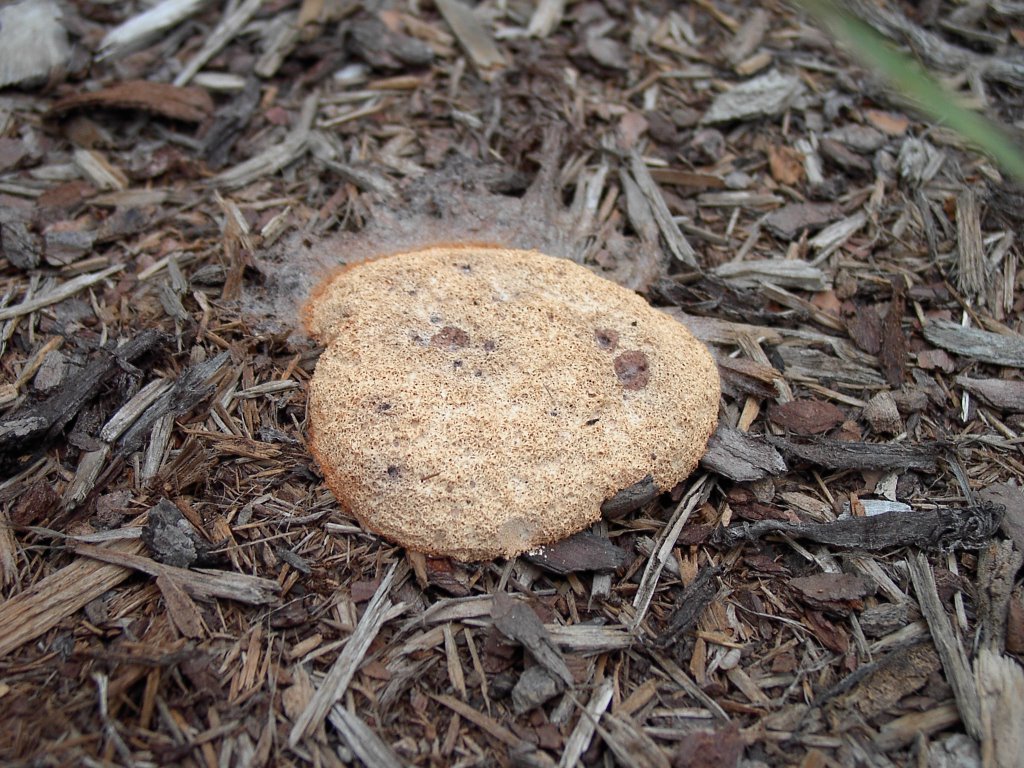
Fuligo septica in a quasi-hibernation state
My botany course lecturer, a mycologist, told an amusing anecdote about slime molds. Way back in the 1960's, Americans were experiencing a rash of UFO sightings and rumours of alien invaders were common. Apparently slime molds can grow quite large in ideal conditions and one day someone spotted a monster slime mold several square metres in size in their backyard. They called the police and when they arrived they thought it was some sort of alien from outer space. Their response was typically American: they shot it!
Where do slime molds fit into the ecosystem? They belong to a class of creatures known as detritivores. They process dead plant and animal material and turn it back into elements that can be reused. If they didn't perform this vital task we'd be neck deep in crap in no time at all! So next time you see this little critter don't cringe in fear, it's one of the good guys.
Sunday, November 27, 2005
Helmet Cam
Ever wanted to see what it's like to ride the Don Valley biking trails? Here's your chance. The bikers are having fun with helmet mounted videocams. I like this video the best. He goes over bridges and under overhangs. Another video is just straight trail riding with only one teeter-totter.
The state of the biking trails will be a future article for the Don Watcher.
The state of the biking trails will be a future article for the Don Watcher.
Thursday, November 24, 2005
Evergreen Open House
At some point in the next two years, Evergreen plans to start renovations at the Brick Works. Depending on how much money they get during their fundraising drive the impact could be moderate to large. At any rate things will definitely be changing at the Brick Works sometime in the near future.
They are making an effort at being open and inclusive as to their plans. Along these lines they are holding an open house next week on Tuesday November 29 and Thursday December 1st at the downtown YMCA. If you want to put your 2¢ in, now's your chance. Here is a PDF that has all the event information.
They are making an effort at being open and inclusive as to their plans. Along these lines they are holding an open house next week on Tuesday November 29 and Thursday December 1st at the downtown YMCA. If you want to put your 2¢ in, now's your chance. Here is a PDF that has all the event information.
Monday, November 21, 2005
N 43° 41.160 W 079° 22.120
Latitude and Longitude are plotted in terms of degrees, minutes, and seconds. This location happens to be in the vicinity of the Don Valley Brick Works. Why is this exact location significant? Because it is the location of a geocache. Geocaching is a worldwide treasure hunt game. It utilizes the global positioning satellite (GPS) system setup by the US military during the cold war. In the year 2000, they allowed access to the general public. Shortly afterwards geocaching was invented.
To play it you need a GPS locator device (see picture). These devices are moderately expensive ranging from $100-300 per unit. My Explorist 100 is near the lower end. When you turn it on it immediately starts to search for satellites overhead. This process takes about two minutes. Once a position has been fixed, it displays the latitude and longitude and constantly updates it as you move around. Depending on the unit it can be accurate to about 3 metres.

GPS Locator device
In the geocaching game you can be either a Cacher or a Seeker. If you are a Cacher, you obtain a small container such as a plastic Tupperware container that is water proof and place in it a logbook, a pencil, and a collection of small trinkets - just like a treasure chest! You then place this anywhere you like, in the city, in a park, or out in the country. With your GPS locator you determine its location. You then post this information on the geocache website. You can make it easy or hard to find.

Contents of another Don Valley cache. This one is contained in a modified ammo box, specially sold by the Geocache suppliers.
Being a Seeker is the best part of the game. You go to the website and note down locations of caches in your area and then go out and try to find them. Uncovering a geocache is always enjoyable, it's like opening up a present under the Christmas tree.
When you find the cache, you open the container. You're supposed to write your name and date in the logbook. You can take one of the trinkets as a memento of your find. Some people also put more stuff back into the container so the contents are always changing. However nothing valuable is ever stored in a cache. We took a fridge magnet and left a breath mint.

My friend holds the container and our loot!
We also took a geocoin (in her left hand). This is a special geocache item. Each coin is individually numbered. The first person puts it into a cache. Someone else retrieves it and then moves it to another cache somewhere else. You then post a separate log of this on the geocoin website and then you can see where this coin has been. Some coins travel all around the world. This coin, number 3007 has moved around the Toronto area and once to Algonquin Park.
There are over 100 geocaches in the Toronto area and about a dozen in the Lower Don. It took me a couple of tries to find the Brick Works cache because it located in a area of deep undergrowth. At some point I will become a cacher and place them in interesting places in the valley.
Sunday, November 20, 2005
The Salted Don
We've just had our official first stay-on-the-ground snowfall this winter and out came the bags of salt. Yes, it got kind of slippery on Friday night but do we really need mountains made of road salt to stop us from slipping? It's amazing that this is the first reaction people have: it's snowing, I'd better throw some salt on it. I hate road salt. When it's a snowy or slushy day I can just imagine it eating though my pant cuffs and my boots. The evidence is there at the end of the day when your red pants (or black or brown or whatever colour) have turned completely white at the bottom.
And quite frankly, it doesn't help all that much. Dumping a pile of salt in front of your house or in front of a store will melt the ice briefly but then, if you don't do something about it once it's melted, the pile of slush and salt will freeze up again.
When all those salt trucks go out on a run in bad weather, you can see the salt just flying off. And that salt, mixed with run-off water eventually ends up in our rivers. On a snowy day, watch the spray come off the roads from the DVP. It's quite stunning how much goes over the wall right into the Don Valley and ultimately ends up in the river. What concentration of salt would it take to turn the Don River into a salt water body?
Use something else! Put a little bit of elbow grease into things and shovel the snow off the sidewalk. Use sand and give folks a little grit. It'll make your pants dirty but won't eat away at them. You're better off in the long run. Just stop using salt.
And what is that salt stuff that's blue? That's scary stuff!
Friday, November 18, 2005
Keating Channel
This is part of an occasional series on interesting places along the Don River.
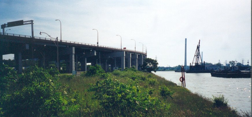
The Keating Channel is a rather dreary place but it is significant for the Don because this is where the river ends up. Located in the northeast corner of Toronto harbour, it still retains part of its industrial heritage.
It was built in the early part of the century as part of the project to fill in a lakeside marsh that stretched from Cherry St to Leslie St. It runs east from the harbour for about 800m before it ends at a sharp turn north where the Don River begins. It used to extend eastward all the way to Leslie St. but this eastward extension was filled in during the 1930's.
Today it is flanked by the elevated Gardiner Expressway and Lakeshore Blvd. East on the north side. The south side is shared by a city harbour works yard and the Keating Channel Pub. At the west end Cherry St. crosses the channel over a little used lift bridge.

The Keating Channel, looking east. In the foreground is an old Task Force planting site. The Gardiner Expressway is on the left. The dredger and the works yard are on the right. The smokestack in the distance belongs to the inactive city recycling incinerator.
It's impact on the Don is varied. Both sides of the channel are lined with concrete dock wall which creates a forbidding barrier and provides little habitat for fish and other water dwelling creatures. The Don is home to about 21 species (pg. 19) of fish. Only about four or five species can be found near the mouth. This is partly due to poor water quality but also due to lack of habitat. The dock wall continues, mostly unbroken all the way to the Riverdale Park section. In contrast the Humber River which does have a natural mouth is home to about 44 species.
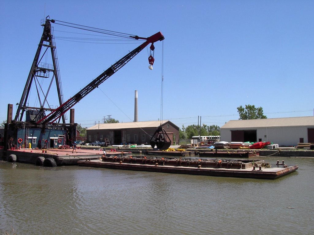
Once water from the river flows into the channel it is basically in the lake because it is level with the harbour. Due to the low flow situation all the silt carried by the river is deposited in the channel. This makes it convenient for the conservation authority (TRCA) to dredge the silt. Currently they dredge about 35,000 cubic metres of sediment from the channel every year. The dredgeate material is barged out the Leslie Street spit where it is dumped in a containment area specially built for this purpose. The spit containment area has the capacity to take 50 years of Don River dredgeate.

Dredger at work. When the barge is full it will be towed to the Leslie Street Spit where its load will be dumped.
Another problem affecting the channel is floating debris that is washed down the Don. Mostly logs and dead wood, there is also an assortment of garbage that collects in the channel. The TRCA corrals this stuff with a boom across the channel. There can be quite a bit of flotsam especially after a big storm.

Debris leftover from the Aug. 2005 storm. A boom keeps the debris from entering the harbour.
Not all of the channel is in bad shape. On the north side of the channel a slight bend in Lakeshore Drive created an open space. The Task Force (and partners) decided to plant this area in the late 1990's. That was one of the first plantings I did in 1998. I still remember what terrible conditions it was for digging. Just below the sod was a mass of ash and brick with very little soil. We planted Staghorn Sumac (Rhus typhina) Peachleaf Willow (Salix amygdaloides) and Red-osier Dogwood (Cornus stolonifera). Only a few of the dogwood and willow still survive but the hardy sumac has thrived. These days it looks like a long narrow glade of small trees and shrubs, a small oasis amongst the blight of concrete and asphalt.
It is difficult to say what future there is for the Keating Channel. The channel as well as adjacent properties are the subject of an environmental assessment (EA) which aims to naturalize the mouth of the Don. It could remain the way it is now, it could be filled in or it could become part of a network of canals throughout the portlands. All of these are options being studied in the EA process.
Regardless of its ultimate fate, the channel remains a small but important part of Toronto's history.
The Keating Channel is a rather dreary place but it is significant for the Don because this is where the river ends up. Located in the northeast corner of Toronto harbour, it still retains part of its industrial heritage.
It was built in the early part of the century as part of the project to fill in a lakeside marsh that stretched from Cherry St to Leslie St. It runs east from the harbour for about 800m before it ends at a sharp turn north where the Don River begins. It used to extend eastward all the way to Leslie St. but this eastward extension was filled in during the 1930's.
Today it is flanked by the elevated Gardiner Expressway and Lakeshore Blvd. East on the north side. The south side is shared by a city harbour works yard and the Keating Channel Pub. At the west end Cherry St. crosses the channel over a little used lift bridge.
The Keating Channel, looking east. In the foreground is an old Task Force planting site. The Gardiner Expressway is on the left. The dredger and the works yard are on the right. The smokestack in the distance belongs to the inactive city recycling incinerator.
It's impact on the Don is varied. Both sides of the channel are lined with concrete dock wall which creates a forbidding barrier and provides little habitat for fish and other water dwelling creatures. The Don is home to about 21 species (pg. 19) of fish. Only about four or five species can be found near the mouth. This is partly due to poor water quality but also due to lack of habitat. The dock wall continues, mostly unbroken all the way to the Riverdale Park section. In contrast the Humber River which does have a natural mouth is home to about 44 species.
Once water from the river flows into the channel it is basically in the lake because it is level with the harbour. Due to the low flow situation all the silt carried by the river is deposited in the channel. This makes it convenient for the conservation authority (TRCA) to dredge the silt. Currently they dredge about 35,000 cubic metres of sediment from the channel every year. The dredgeate material is barged out the Leslie Street spit where it is dumped in a containment area specially built for this purpose. The spit containment area has the capacity to take 50 years of Don River dredgeate.
Dredger at work. When the barge is full it will be towed to the Leslie Street Spit where its load will be dumped.
Another problem affecting the channel is floating debris that is washed down the Don. Mostly logs and dead wood, there is also an assortment of garbage that collects in the channel. The TRCA corrals this stuff with a boom across the channel. There can be quite a bit of flotsam especially after a big storm.

Debris leftover from the Aug. 2005 storm. A boom keeps the debris from entering the harbour.
Not all of the channel is in bad shape. On the north side of the channel a slight bend in Lakeshore Drive created an open space. The Task Force (and partners) decided to plant this area in the late 1990's. That was one of the first plantings I did in 1998. I still remember what terrible conditions it was for digging. Just below the sod was a mass of ash and brick with very little soil. We planted Staghorn Sumac (Rhus typhina) Peachleaf Willow (Salix amygdaloides) and Red-osier Dogwood (Cornus stolonifera). Only a few of the dogwood and willow still survive but the hardy sumac has thrived. These days it looks like a long narrow glade of small trees and shrubs, a small oasis amongst the blight of concrete and asphalt.
It is difficult to say what future there is for the Keating Channel. The channel as well as adjacent properties are the subject of an environmental assessment (EA) which aims to naturalize the mouth of the Don. It could remain the way it is now, it could be filled in or it could become part of a network of canals throughout the portlands. All of these are options being studied in the EA process.
Regardless of its ultimate fate, the channel remains a small but important part of Toronto's history.
Monday, November 14, 2005
Please Water our Trees: Roundtable Report
As I reported last week, the mayor's Beautiful City Roundtable made a presentation on street trees which also mentioned ravines. I thought it might be pertinent to the Don so I obtained a copy of the report.
However it talks mainly about street trees and makes only a passing reference to ravines. Janet Rosenberg, the author of the report, makes some valid points about the state of street trees. The need for watering is one that the Task Force has repeatedly made. This applies to new plantings for ravine and street trees. Newly planted trees need a steady amount of water in the first couple of years. If drought conditions occur like they have over the past 4-5 summers then we need to water our trees. If not then we have unsightly rows of dead trees on our streets and clumps of dead sticks in our ravines.
The trees we plant in the valley are done mostly by volunteers. If we let our trees wither and die after the initial planting that can only have a negative effect on our volunteers. They see this when they revisit the planting site. This could have a disheartening effect on their future volunteer activities. Watering is good for both the body (trees) and the mind (volunteers) .
Sunday, November 13, 2005
New Contributor to Don Watcher
Don Watcher welcomes a new member, River Rat. River Rat will help provide a different perspective of the Don, something a little more lively than my sober prose and wry wit. We're trying to get a little more interactive: you're comments and feedback would be most appreciated!
Saturday, November 12, 2005
Top Five List: Favourite Things About the Don
Donwatcher has invited me to contribute to the Don blog about all things Don River. I thought I'd start with a complementary posting to his Top Five List: Threats to the Don with my own Top Five List: Favourite Things About the Don (though not quite as robust as Donwatcher's)
1. The darkness of the Valley as you travel over it on a late-night subway ride and the contrast to the bright headlights from cars on either side.
2. The height of the wall at the back of the Brickworks. You feel like you're in the bottom of a big bowl.
3. The Riverdale Farm Ponds as evidence of an old Don River Oxbow.
4. "The River I Step In is Not the River I Stand In" public art installation on the Queen Street East bridge that reminds people that there is a river underneath them that courses through the city.
5. The fish ladders south of the Beechwood Wetland.
What are yours?
Tuesday, November 08, 2005
More November Documents
Now that the community council agenda have been posted there are additional documents that may be of interest to Don Watchers.
1048 Broadview Avenue Development
This is a proposed condominum project at the top of Pottery Rd. The proposal is to erect a 22 story tower on site. Staff largely recommends the project with the option of forcing the developer to subsidize some cosmetic improvements to the valley. While there is a similar tower just to the north of this property, does the valley really need another condo?
Bridgepoint Health (formerly Riverdale Hospital)
An update on development proposals for this long term care facility. More of a community issue than a valley issue, there are some aspects of this project that may impact the Don so it should be monitored.
Beautiful City Roundtable Comments on Ravines
I'm still looking into this one. Committee member Janet Rosenberg made a verbal report to this committee on the subject of street trees and ravines. I'm trying to find out what impact this may have on the Don. More on this later.
Sunday, November 06, 2005
Top Five List: Threats to the Don
Everybody produces these lists so why not a list for the Don? The Don is threatened by a wide range of factors so I thought that a list of threats would be particularly relevant. Here is my list:
4. Inappropriate human use
5. Government bureaucracy

1. Stormwater runoff
2. Non-native invasive species
4. Inappropriate human use
5. Government bureaucracy
You may want to reorder these or add to them and I would be interested in hearing your opinion. Until then I will delineate my reasons for each. Since some of these are lengthy topics I will post a separate article for each. Today's article is #4.
4. Inappropriate Human Use
This is a bit of a catch-all for a variety of actions all human based. It's a combination of use, abuse, and overuse of the natural resource that our ravines and valleys provide. I will list a few of them here.
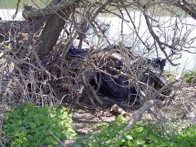
Living in the valley. As if the city doesn't provide enough space for humans to reside, some of us insist on setting up shop in the valley. Grouped under the eponymous term 'homeless', people reside in the valley for a number of reasons. Some people really are homeless and the valley seems a welcome respite to the hardships of street life. Others have jobs to go to but are trying to save money by living off the land rather than paying rent. Still others just want to get away from it all. Regardless of their circumstances, the ravine lands often lack the resources necessary to support a human lifestyle. For example, there is no sanitation so they use the a hole in the ground or use the river. There is no heating so they collect deadwood or chop down trees for a fire. There is no garbage collection so they just leave it scattered on the ground. As well when they finally do leave they abandon many possessions in their campground leaving a toxic mess for the rest of us to cleanup. There are rules that prohibit living in the valley but they are rarely enforced.

Dumping. As the city tightens up on regulations for disposing of waste at landfills or starts charging more for removal, some people think that a convenient and cost effective method is to dump their refuse in the ravines. There are many remote and out of the way places in the ravine system that allow people to dump tires, appliances, building materials, or just plain household waste without being seen. There is little risk of being caught and charged and even then the fines are ridiculously low.
Dog walking. There seems to be more dogs than ever in the city. There are a number of reasons for this that I won't go into but there is a definite negative impact on our natural areas, especially the ravines and valleys. When people take their dogs for walks in parks they like to let them off leash for exercise. While it may not seem that one dog is a problem, hundreds of dogs every day going over the same area is a big problem. Dogs like to root things out, dig up things, chase small animals, etc. This activity in the forest understory when done many times seriously degrades this delicate ecosystem. In some areas frequented by dog walkers, there is little left in the forest except trees and barren ground. When dogs run loose there is also less chance that the owner will dispose of dog feces that they leave wherever they feel like it. Since the ravines are often flooded all this crap gets washed away so we find that dog feces is a common pollutant found in our streams.

Mountain biking. The Don Valley has always been a destination for bikers who seek a challenging ride. Until recently this was considered a niche activity that attracted only a few aficionados. However in the past ten years there has been an explosion of activity in the sport. It is also an official Olympic sport and with the added publicity more and more young people are trying it out. With all the added people, the Don trails are now suffering from the overuse and are eroding badly. In addition the sport has segmented so it's not just trail riders. There is a subgroup called 'free riders' who tear down slopes where there are no trails looking for an added thrill. This causes untold damage to the delicate conditions found on valley slopes. Another group likes to build stunts. They build series of earthen ramps and jumps and supplement them with wooden trestles and bridges. What better place to do this than in the valley. These earthen and wooden works are often built without regard to the damage they cause to our natural areas.
There are other examples but these give you an insight into how we use our valleys and ravines. It all adds up to a collective lack of respect for our natural urban environment. Unfortunately policy makers say that the GTA will be home to 5 million more people in then next 20 years. If our current population overuses our ravines now what chance does the Don have in the future?
Wednesday, November 02, 2005
Agenda reports for November
Every month the city publishes agenda for their standing committees. Within these PDF files are links to reports on each specific item. Some of these items are directly or indirectly relevant to the Don. The committees that deal with business that concerns the Don are Economic Development and Parks, Planning and Transportation, and Works.
I think it is important to read these documents becauses it helps me understand the issues that concern the Don. I also publish the links here because I think the Don Watcher readers will also find them interesting. So here are the agenda documents available for November, 2005.
Toronto Water Budget
This is a rather long and dull report but contains interesting information about future directions for Toronto Water. This department is responsible for Toronto's drinking water supply but also for waste water, and that is important to the Don because alot of waster water ends up in the river.
Taylor Massey Creek Outfall Management
This is a supplementary report to previous studies that reports on correspondence and responses to those reports. The pollution issue surrounding the TMC outfalls will continue for sometime. A couple of positive outcomes have resulted in the TMC study. Firstly, Toronto Water is expanding its outfall monitoring program to encompass the entire city, and secondly are hiring more people for ongoing monitoring. Both are worthwhile results.
Mandatory Downspout Disconnection Program
A briefing note to council from staff for this program which was instituted in 1998.
Wet Weather Flow Funds for Tree Planting
The city is committed to providing $250,000/year to community groups for tree planting projects. Trees help to reduce storm water flow by slowing rain down and retaining the moisture. The cumulative effect across the city can lead to a significant reduction.
Replacing Lost Snow Dump Capacity
This is a very interesting report that portrays the land use pressure the city is under in its ability to provide land for snow dumping. Based on the number of truck loads needed to cart away snow plowed from city streets (using Mel's storm in 2003 as a baseline), the city needs places to dump 150,000 loads of snow. Currently there are three valley sites, two of which are beside the Don. Understandably the Task Force wants them shut down. The city's response is there's nowhere else to put it. New melting technology may be the direction to go.
Chester Springs Marsh
The Task Force has requested funds from the city to provide a report on the status of the marsh. Our concern is that the marsh is not functioning in the way it was envisioned and may need some remediation work.
Thursday, October 27, 2005
Invasive Species Blog
Likely the second biggest threat to the Don is non-native invasive species, especially plants and trees. These are aggressive species that literally take over an area where nothing else grows. They love to colonize disturbed sites which is pretty much the state of the entire lower Don. Species that are a big threat are Japanese Knotweed, Dog-strangling Vine, Garlic Mustard, and Canada Thistle (actually a native of Europe).
I have just found a weblog devoted to invasive species. Entitled Invasive Species Weblog, it gathers articles from all over the world about invading plants, fish, crustaceans, and other animals. The blog is written by Dr. Jennifer Forman Orth. Each entry is chock-a-block full of information and links to other related websites. If your interested in this type of information then be sure to bookmark this blog because it is top-notch stuff!
Recent posts have included an article on how native Lake Erie water snakes are making a comeback by feasting on invasive Round Gobys; an article from New Zealand about an invasive algae from North America called Rock Snot (Didymosphenia geminata); and recently an article from South Africa about an initiative to make coffins out of the wood from invasive trees.
P.S. I said the 2nd biggest threat. So what's the biggest threat? It has to be stormwater runoff, or is it dealing with the city bureaucracy? Perhaps a list of the top five threats to the Don will be the subject of a future posting...
Sunday, October 23, 2005
Become a Deputy Don Watcher
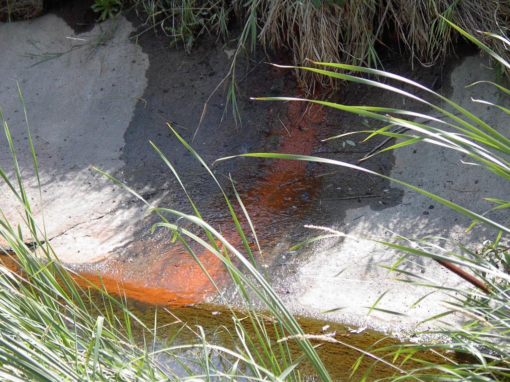
Orange leachate seeping into Taylor-Massey Creek
(click to expand)
As you well know, our Toronto creeks, streams, and rivers are not pristine and pure like something you might find in the boreal forest or the mountains. Many of them have pipes and stormwater outfalls dumping water into them from unknown sources. Frequently the water is polluted with dissolved chemicals and e.coli bacteria. E.coli is an organism that is present in human sewage. When it shows up in the river you know that it came from somebody's toilet.
Sanitary sewers are all supposed to be connected directly to the treatment plant system but sometimes a property owner makes an improper or illegal connection to the storm sewer system. It's also possible for the sanitary system to leak into the storm system, especially in the older parts of the city.
A recent study of outfalls along Taylor-Massey Creek reported e.coli counts from 300/100 ml upwards to 1,200,000/100 ml. The Provincial Water Quality Objectives specify that safe levels should not exceed 200/100 ml. The city's sewer use bylaw specifies levels of only 100/100 ml.
Of course it's often difficult to tell by looking at the water. The water may look clear but it can still be very polluted because bacteria are microscopic and other chemicals can be dissolved colourless in the water. However if you do see the water stained by a chemical, or there is a bad smell or there is anything out of the ordinary, there is some recourse.
Toronto Water has a spills hotline, 416-338-8888 which is monitored 24/7. Call this number and be prepared to describe what you saw, the location, and the date and time. Staff are pretty competent in dealing efficiently with a chemical spill as long as they know about it soon after it occurs. If they have enough information they can usually trace the spill to its source and take remedial action.
So if you are like me and bike or hike in the valley, you can now take personal action if you see some bad looking water. Anyone who does see something and reports it, let me know and I will appoint you a deputy Don Watcher!
Friday, October 21, 2005
Turning the Big Pipe into the Big Process
Toronto city councillors decided to stick their noses into York Region by voting to ask the province to defer further work on the York Region sewer project known as the 'Big Pipe'. Toronto wants this project to go through a full Environmental Assessment (EA).
The problem is that in order to pump all the sewage through the system, engineers need to supplement the flow with local water, and they're talking about millions of litres of water. Such a volume could de-water local wells and have serious negative implications on base flows for the Don and Rouge Rivers.
York Region, understandably is pissed because, firstly they think Toronto should butt out of their turf, secondly if this does go to a full EA it's going to slow down the project by at least two years, and thirdly they secretly know an EA will reveal the truth about this project.
Most of the local papers reported on this matter including the Globe and Mail.
Go Toronto!
Thursday, October 20, 2005
Fall Colours in the Don
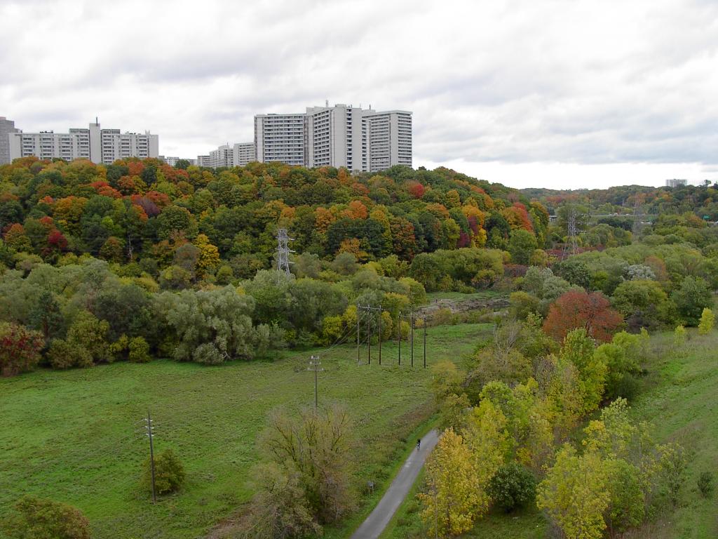
View from Leaside Bridge
(click to expand)
For anyone who thinks they need to travel north to see the fall colours, they should come out to the Don valley instead. You can see vibrant colours and nice vistas like this one in the woods just north of Pottery Road called Crothers' Woods. The last two weeks of October will likely be the best time for viewing. The easiest access if your driving is from the Loblaws parking lot which is just off Millwood Rd. By TTC take the 100 Flemingdon Park bus from Broadview Station and get off at either Pottery Road or at Beechwood Drive.
Enjoy!
Monday, October 17, 2005
No Go on Nordheimer
To be discussed at the Toronto and East York Committee meeting on Tuesday Oct. 18 is a little development plan on Russell Hill Road which borders on the Nordheimer Ravine, one of our nicer restoration areas. The developer is proposing to knock down one house and build two apartment buildings, a 4-storey and a 5-storey. There are currently 150 trees on site. The developer wants to chop down 86, 22 of these are mature, measuring >30 cm in trunk diameter. This violates the zoning bylaw, the ravine bylaw, the private tree bylaw, and the bylaw that says the city can't be so stupid as to approve a plan like this (OK, I made up the last one). City staff have quite rightly recommended that this proposal be turned down.
Look for this one to be appealed to the OMB. For your information, here is the city's report on the matter.
Look for this one to be appealed to the OMB. For your information, here is the city's report on the matter.
Friday, October 14, 2005
Taylor-Massey Creek Pollution Studies
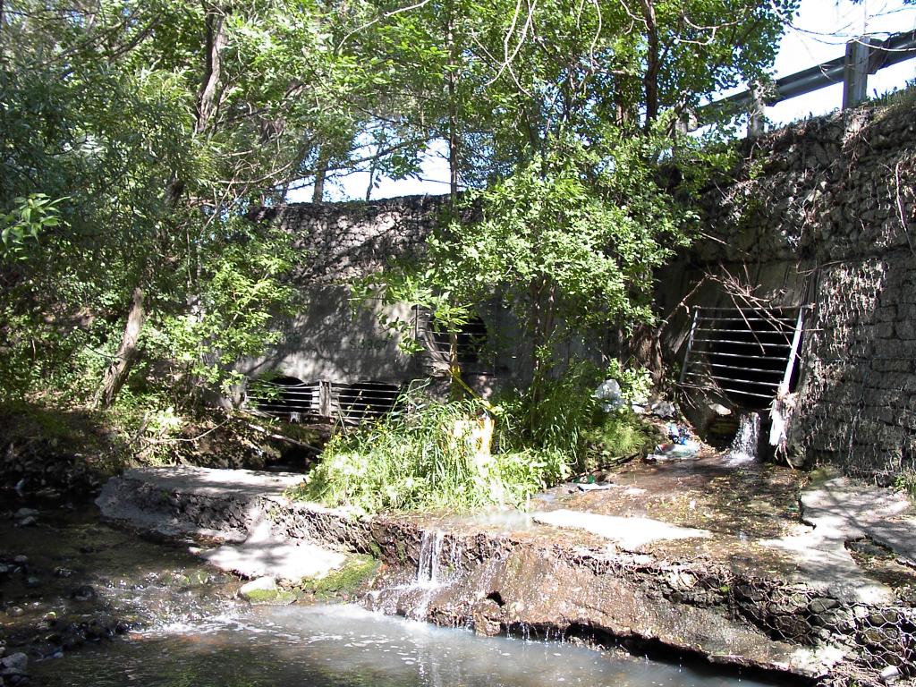
Outfalls near St. Clair Ave. East and Birchmount
(Click to expand)
I'm still working on part III of the Taylor-Massey story but in the meantime I thought I would bring you up to date on some recent reports on Taylor-Massey Creek released through the Works Committee.
Last spring a spill occurred in the creek created by a very visible red dye. When staff said they didn't know where it came from, local councillor Janet Davis said they had bloody well better find out. Apparently this has lit a fire somewhere in the Works department because they have actually done some serious monitoring in TMC over the summer.
To no one's surprise they found that the creek is seriously polluted. Staff located 153 outfalls between the mouth and Pine Hills Cemetery. They plan to locate the remaining outfalls by next summer. Of the 153 outfalls, at least 68 have a base flow. Of those, 21 show levels of e.coli bacteria and other pollutants that exceed municipal and/or provincial water quality guidelines. In particular, e.coli levels greatly exceed the guidelines with one outfall showing a level of 1,200,000/100 ml. To put this in perspective, the city closes its beaches when levels exceed 100/100 ml!
Staff intend to do further studies on these 21 outfalls to determine the source of the pollution.
Storm Outfall Monitoring Report
Table 1: Outfalls Exhibiting Contamination
Table 2: Contaminated Outfall Locations
Also released is a report listing studies planned over the next year. These include a geomorphological study and a report on the feasibility of initiating (don't you just love city speak?) a class EA to remediate TMC outfalls.
Mike Adler, a reporter for the East York Mirror, attended the Works Committee meeting and has written two articles on this subject. Here are the links to the articles:
Creek Water Like Sewage: Tests Show
Action on Creek Pollution Promised
Monday, October 10, 2005
Bike Hike Report

View of the valley from "Party Atmosphere"
(click to expand)
I led a hike on Saturday. The route of this hike was along the trails in Crothers' Woods and E.T. Seton Park that are popular with mountain bikers. This was a joint endeavour of Bring Back the Don and the Toronto Bruce Trail Club. 43 hikers plus two leaders made for a fair sized group - down from 62 on my hike in the spring. Some people may have been deterred because it rained most of Friday, however the trails were in surprisingly good shape.
We spent most of the morning making our way through Crothers' Woods starting at Pottery Road and we had lunch at the south end of E.T. Seton Park (that's the park where the Science Centre is). We had some dropouts but most stayed for the challenging second part. This is a trail nicknamed "Party Atmosphere" by the bikers mostly because it is a technically challenging ride. It is also a tough hike.
The second part was easier than I anticipated so we finished up a little ahead of schedule. A long ride to the Bow & Arrow pub afterward for refreshments attracted 14 hikers. I received high praise for a well planned hike, although when I do the hike next year I plan to add another loop to add another hour or so to the route. That should please the hard core hikers even more.
Thursday, October 06, 2005
City Documents
New documents from city committees:
Terms of Reference for Wet Weather Flow Implementation Advisory Committee. This new committee will be populated by a wide range of 'stakeholders' from across the city, including at least 4 people representing groups in the Don watershed. This was presented at City Council in September.
Final Report for the Warden Corridor Land Use Planning Study. This report details urban uses for the area on the east side of Warden Avenue that runs from Danforth Rd to just north of St. Clair Ave. East. It seems to be big on building apartments and condos but light on environmental matters. This will be discussed at the Planning and Transportation Committee for Oct. 6, 2005.
Andrew McCammon and the Taylor Massey Project have published a policy document that argues for greater protection for Warden Woods when developing this area.
Tuesday, October 04, 2005
Taylor Massey Creek: The FODEY Story, Part II
Friends of the Don East York has had a long history of advocacy and environmental projects in Toronto. They started up in the early nineties around the same time as when the Task Force to Bring Back the Don got going. They provided the same sort of function in East York as the Task Force did in pre-amalgamation Toronto. The only difference being that they operated as a non-governmental organization.
FODEY was active in pushing East York Council to be more environmentally aware especially in the East York Official Plan. On environmental issues they were at the front lines fighting against the Leslie Street extension. During this time they persuaded the TRCA to designate Crothers' Woods as an Environmentally Significant Area (ESA) which was important at the time since Crothers' Woods was directly in the path of the extension plan. It still is but that plan has now morphed into a bus only road to be built as part of the Don Valley Transportation Master Plan.
Locally, they started a program called “Another Yard for the Don” which encouraged home owners to grow native plants and to create pesticide free zones. Another program called "Trees Count" was a survey of neighbourhood trees that encouraged property owners to plant trees. It also highlighted the problem of even aged street trees which may start dying off all at the same time, leaving our streets without their leafy canopy.
Of course FODE has always been pushing for restoration of the Taylor Massey Creek watershed. Some of their naturalization projects include the Goulding Estate on Dawes Road and Warden Woods. Recently FODE has started work on the degraded ravines between St. Clair and Eglinton.
The most recent project involving the creek is the Taylor Massey Project. The project known as TMP divides the watershed into 12 parts called reaches. Each reach is described using a series of aerial photos. The project's main goal is to highlight the issues and concerns that are sprinkled throughout the watershed. Another project goal is to create a trail along the entire length of Taylor-Massey Creek. The project is fully detailed on FODE's website with maps and descriptions.
After amalgamation when East York was merged into the City of Toronto they dropped the 'Y' and became just FODE. Recently FODE has attained charitable status. While this limits its ability to do advocacy (Canadian charities are not supposed to be politically active), it does allow it to raise funds more easily. They now have a grant from the Ontario Trillium Foundation which allows them to pay for an executive director.
Stephen Peck was the chair of FODE from its inception to about 1999. At that time he stepped down to pay more attention to his company called Green Roofs. Andrew McCammon stepped in and ably filled this role until late 2004. During this time he focused on the creation of the Taylor Massey Project. Also during this time he shepherded the process of converting FODE into a charity as well as the successful Trillium grant application. He departed abruptly to lead his own organization called the Taylor Massey Project. This created some consternation and controversy which will be the subject of part 3 of this story. Presently James McArthur fills the role of chair.
FODE's current focus is the creation of a network of stewardship teams to take care of important sites in the Taylor Massey watershed as well as planning for some new restoration sites. It is hoped that this will include at least one medium sized wetland project.
Next: the FODE - TMP schism, or this watershed ain't big enough for the two of us!
Sunday, October 02, 2005
Dog Run Update
Back in August I reported a little contretemps about a former restoration site being appropriated by an expanded dog run. After a lot of back and forth (and also after everybody got back from vacation), it was decided that yes this was inappropriate, that whomever made the decision in the first place overstepped their bounds and something needed to be done.
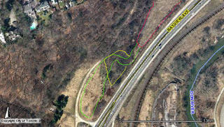
Enter the old fashioned compromise. In the accompanying map the original dog run (red) was added to by the new fenced area (green). The compromise (yellow) shows a more limited expansion that removes much of the restored area from the fenced dog run.
That's the new plan. Now all we need to do is reconfigure the fence and repair the damage to the restoration site. Nobody's sure when that will happen but at least we have an agreement to provide locks for the gates so no one has access until this is resolved. This is not likely to be the end of the story so stay tuned...
Tuesday, September 27, 2005
Species at Risk

Swamp-rose Mallow (Hibiscus moscheutos)
(click to expand)
Canada has 487 species at risk as defined by the Species at Risk Act (SARA). Of these 13 are extinct, 22 extirpated, 184 endangered, 129 threatened, and 152 of special concern. Species are placed in a category depending on a variety of factors which include overall numbers, amount of habitat, food sources, climate conditions, disease etc. Unfortunately the list keeps on growing.
I have done some research on the SARA plant species for the Native Plant Database run by Evergreen. Most of the plant species listed suffer from one cause: habitat loss due to human encroachment. Wetlands in particular are at risk. We seem to drain them, plow them under, or fill them in with alarming regularity. Developers and property owners view them as a waste asset. Also who wants a swamp behind their shopping plaza? Better to pave it and make it a parking lot!
Not many people seem to realize that wetlands are one of Canada's most diverse ecosystems, supporting many species of plants and animals. The above pictured plant is just one of our wetland wonders. I found this one growing at one of our restored wetlands in the Don at the Brick Works. Swamp-rose Mallow is a rather striking and beautiful flower that grows at the edge of wetlands. It is currently listed as a species of Special Concern by SARA and it is restricted to wetland areas of Southern Ontario. As already mentioned these areas continue to disappear. At the Brick Works it seems to be flourishing and is growing in at least three places. In established areas it can grow into clumps of up to 70 plants. That's probably an amazing sight.
Each flower produces about 100 seeds. According to the description, the seeds are eaten by ducks. Some of these seeds are later excreted by same and this way can be spread to new wetlands.
This year I am performing a small experiment. I collected a couple of seed heads and will try to grow these seeds at other Don wetlands (no ducks will be harmed in this process). This is one plant that is worth propagating. I will keep you posted on the results.
Saturday, September 24, 2005
Taylor Massey Creek: Tale of a Watershed, Part I
I have a story to tell. I started writing but it became so long I felt it would be better break it into three or four parts. Part I describes the geography of the creek and some of the urban issues that affect it.
Taylor Massey Creek is a small river that is part of the Don watershed. It exists entirely within the new city of Toronto. It begins in the city around Pharmacy Ave. and Hwy 401. It flows south and east towards St. Clair Ave. East before turning west to join the Don River, East Branch just north of the forks of the Don.
The northern portion is in the worst shape. For the most part it flows in a concrete lined ditch. In places it is buried in a tunnel and in other areas it flows unseen behind the backyards of a neighbourhood in the Warden and Lawrence area.
Between Lawrence and Eglinton it flows through an industrial area. Only south of Eglinton does it show signs of life. Here the banks are earthen yet somehow it looks as neglected as the ravine park surrounding it. Groves of junk trees such as Siberian Elm and Manitoba Maple shade a sombre looking, slow moving creek, occasionally tinged with the residue from its polluted sources farther north.
Eventually it enters the Pine Hills Cemetery where it is a little more protected. Still at the south edge of the cemetery it is bracketed by two banks lined with ominous looking gabion baskets.
Just west of Birchmount it enters a small park that includes one of the first naturalized areas and the creek begins to show hints of what it surely used to look like before Toronto started to strangle it with development.
South of St. Clair is where it looks it best. From here, back down to Pharmacy, it occupies a ravine park called Warden Woods. Here the creek is allowed to meander mostly unhindered. However there are signs of past abuse such as a pipe crossing the bed of the creek which has become unearthed due to erosion.
Between Pharmacy and Victoria Park the creek is again lost, this time occupied by a city owned golf course called Dentonia Park. The only way of viewing the creek is by playing a round of golf.
West of Victoria Park one can walk uninterrupted all the way to the Don. This section is called Taylor Creek Park and is well used (maybe too well) by dog-walkers, mountain bikers, joggers and family outings. The mouth of the creek empties into the Don, but it is unceremoniously shadowed by the Don Valley Parkway under which it flows.
Now for a few facts. Taylor Massey Creek (TMC) is seriously degraded by storm water outflows. The post war planners who hastily built the surrounding suburbs of North York and Scarborough didn't pay too much attention to where they directed the waste water. The thinking then was get it away fast, out of sight, out of mind. TMC was the unfortunate recipient. The result it that whenever there is a rainstorm TMC fills up and flows quickly. In some places it overflows its banks causing damage to the surrounding parkland. With the runoff flows the usual litany of pollutants such as oil, grease, salt, lawn pesticides and fertilizers, and of course, dog shit. One study estimated that TMC is responsible for 80% of the pollutants in the lower Don after a rainstorm.
The planners who put together the Wet Weather Flow Management Master Plan recognized this and have targeted TMC for major improvements in the 2008-12 time period. They would have started work earlier but Highland Creek just to east of TMC is in even worse shape. So Highland Creek is being worked on instead of TMC.
The upper reaches of the TMC watershed are in such bad shape that the Works department no longer recognizes it as a functioning watershed. The headwaters of TMC, just north of the 401 now flow into a storm sewer that empties into Highland Creek. The creek has frequently been manipulated in this way to its detriment.
Not everything looks so bleak. The new headwaters, just south of the 401, have been restored by the TRCA into a model series of naturalized ponds and islands with connecting swales that have been fully planted with native reeds and flowers. Visit Terraview Willowfield if you ever want to see what TMC could look like.
Next: the FODE story.
Monday, September 19, 2005
Green Frog
(click to expand)
One of my favourite places to visit is the Don Valley Brick Works. I was there today to work on a pet project - a survey of flowering plants. The survey is a personal project. I thought it would be good to create an inventory of species in the quarry ponds. To do a proper inventory you need to visit at least three times of the year, once each during spring, summer, and fall. So far I have completed the summer and fall surveys. Without going into too much detail, I have catalogued about 70 species of which 28 are non-native. Of these 12 are considered invasive. At least there are more natives than non-natives - a good sign?
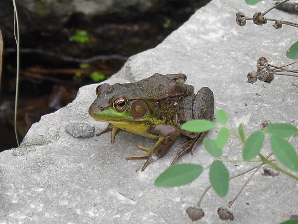
While doing the survey I came across this little guy sitting on a stone at the edge of a pond. He was nice enough to let me take a few pictures including the one displayed here. This is a Green Frog (Rana clamitans). It is one of two common species found in the Don. The other is the American Toad (Bufo americanus). Both species have managed to adapt to the urban environment. They can often be found hibernating in backyards. Other species need a less disturbed habitat so you won't find them in the Don. Both the Green Frog and the American Toad have been seen at the Brick Works.
I happen to know this is a male frog. This can be determined by looking at the large brown circle behind the eye. This is the eardrum. If the circle is noticeably larger than the eye, it is male; if it is about the same size it is a female. Green Frogs are more often heard than seen. The mating call is a single low-pitched twang, sounds like 'galamp' or 'galumph'.
The Metro Zoo has a website called Adopt-A-Pond and it is a good source for information on pond dwelling creatures, including the Green Frog. If you visit this site you can hear a recorded sound of their voice.
Saturday, September 17, 2005
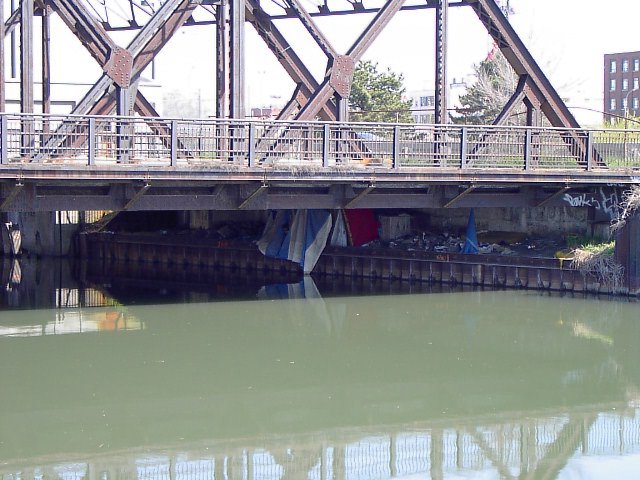
Valley is a little less homeless
People living in the valley has always been a touchy subject for us. Technically speaking there are bylaws that say that nobody can live in a city park which is what most of the Don is (zoned as undeveloped parkland). However the city has chosen to overlook the fact that people have been pitching tents in the lower Don mostly because they can't deal with people living on the street. Whenever the issue has been discussed by the Task Force we have been made to feel like crass, unfeeling opportunists. So the valley experiences an urban blight in places, especially on the west side of the river just south of the Bloor viaduct.
However two things have happened recently to change things a little. First , the storm that occurred in August found some of the campers up to their armpits in muddy, fast flowing water. They had to beat a hasty retreat to higher ground as their posessions were washed away. In one case the police marine unit had to rescue one of them who was stranded on a newly formed island. The sudden realization that, yes this is a floodplain, has dissuaded most of them from returning.
Secondly, the city has created a successful program called "Streets to Homes". Created to address the problem of homeless sleeping in Nathan Phillips Square, the program has removed people from the street by finding them permanent accommodation. Outreach workers from this program have approached the Don homeless and is now starting to place them in apartments.
This was reported in an article in Saturday's Globe and Mail (for some reason the article is not available on their website). So the upshot is that the homeless get a permanent residence and we get a valley that can be restored with a little less human interference. Our next move will be to ensure the "Streets to Homes" program is expanded to be "Ravines to Homes" as well.
Thursday, September 15, 2005
Big Pipe Surprise
Last week I reported on several items on the Works Committee agenda that concerned the Don. One item that I thought needed more attention was the York Region Big Pipe. My feeling was that this report would be quietly received and then shelved.
It was a pleasant surprise to wake up this morning and read the Globe and Mail's columnist John Barber who reports that a deputation of York environmentalists deputed before the committee on this item. The committee voted unanimously to support their cause and sick our lawyers on their lawyers.
What business does Toronto have messing around in York Region's turf? Lots. The Don (and the Humber and the Rouge, etc.) doesn't end at Steeles - this is shared property. One argument the environmentalists used was that Toronto had previously supported the battle against Oak Ridges development. Toronto's financial support was instrumental in winning that fight. Now it's doing just the same thing for another insidious urban sprawl-friendly development plan.
Hurray for us. Stopping the Big Pipe can only be good for the upper Don watershed. We need to retain as much natural cover in the upper Don or storm damage like the one in August will only get worse. Or the river might just dry up altogether as the base flow is diverted into the pipe.
You can read John Barber's article online if you have a subscription. If you don't you'll need to read a paper copy (available at any library).
Wednesday, September 14, 2005
Praying Mantis

(click on picture for a close-up)
This has got to be one of my favourite insects. I spotted this guy resting on a pillar beneath the Gardiner near the mouth of the Don. From the order Mantodea there are roughly 2000 species worldwide, mostly in tropical and subtropical climates. It normally holds its two front legs folded up in front of its head like someone praying, hence the name.
A masterful predator, it subsists mostly on flies and insects. It uses its green body to blend in with vegetation and waits for an unsuspecting victim to crawl by. With lightning speed it grabs its prey with its two front legs and quickly devours it. Wikipedia (one of my favourite internet information resources) has a link to another page which someone took of a praying mantis catching a hummingbird! As an opportunistic hunter I suppose it doesn't discriminate as to the contents of its lunch. Creatures like these continue to make the Don a fascinating place.
Monday, September 12, 2005
Infrastructure
The Don Valley is laced with 'infrastructure'. The fact that no one lives in the valley (aside from a few scattered squatters) makes it a valuable habitat for wildlife. It also makes it a preferred target for government to dump stuff that no one else wants.
To date, there are two major highways, two railways, three pipelines, a hydroelectric corridor, two snow dump sites, and a sewage treatment plant. It used to be home to a number of dump sites but these have thankfully been closed down. There is also a network of sewer pipes of various kinds and unfortunately this network is about to expand.
There is currently an old trunk sewer running east under the valley just north of Pottery Rd. It services the Bennington Heights area, a neighbourhood at the south end of Leaside. The sewer pipe is deteriorating and needs replacing. Rather than fix what's there, the plan is to build a new pipe that will run northeast through Crothers' Woods and connect with the North Toronto Sewage Treatment Plant. This wouldn't be too bad except it will slice through some of the best forest left in the lower Don. It will also disrupt some of the city's restoration efforts in the area.
The city is piggybacking on a design project completed by the old borough of East York to start the project without any further input from the public. Since the project was done prior to amalgamation and outside of the old city of Toronto, the Task Force at the time was not informed and even then would not have had any say so. The city was nice enough to let us know that they were starting the project. The Task Force was able to suggest a minor reroute that will cause less impact on the natural areas of the forest but the pipe is pretty much a done deal.
If anyone is interested, project plans can be viewed on Monday September 12, 5-8 PM at Rosedale United Church, 159 Roxborough Drive, at the corner of Glen Rd.
Friday, September 09, 2005
Works at Works
One of the unofficial duties I perform for the Task Force is to browse the agenda of city committees and look for items that are pertinent to the Don. Every month I dig through agendas for Works, Planning, Parks, and the various community councils that might impact the Don watershed. So far this month the Works Committee has the juiciest items. They are:
WWFMMP Implementation Advisory Committee
There's a mouthful. The city is creating a new committee and inviting interested groups, including the Bring Back the Don, to appoint members. It should be noted that the city was going to appoint all the members until the Task Force insisted that we get our own appointee. Now of course everybody gets a piece of the pie.
York Region's Big Pipe
This one is a little vague on its impact to the Don. Basically it is saying there is no direct impact on the Don and the Humber to the sewer construction. What it doesn't address is the indirect affect of draining water from the Oak Ridges moraine. This water might have flowed into the Don. This project could affect base flows of several rivers but there is no data to prove that.
Source protection
Here's an interesting one. The city along with the TRCA is moving to protect water sources within the watershed. The city realizes that protecting water sources of the rivers is as important as protecting the rivers themselves (which belies the previous document, does the one hand know what the other is doing?).
Budget for source protection
Creating a budget for the aforementioned item.
Thursday, September 08, 2005
Notes from the EA front lines
With apologies to Guns n' Roses...
Welcome to the Environmental Assessment
We got evaluation n' consultation
We got everything you want
As long as its technically feasible
We are the people that can find
Whatever the Don River may need
If you got the money honey
We got you a process.
I went to one of the public forums for the Don Mouth Naturalization last night. It is one of the first of many meetings to decide what to do with the mouth of the Don. From the simple vision “Let's build a marsh at the mouth of the Don” we get 2 year process of collecting all the ideas, engaging the stakeholders, mapping the infrastructure, integrating it into existing planning projects, and then after all that's done, build a marsh at the mouth of the Don. Not necessarily the best approach but one that is mandated by the lengthy environmental assessment process. At least the consultants and facilitators are happy.
Attending the event were about 60 people. This was made up mostly of the usual suspects, meaning environmentalists and other community activists who have an interest in the outcome. There were also a few community members who have quite a different viewpoint on what gets done because they will have to live with it (literally).
I forgot that meetings like this brings out a few people with odd perceptions of reality. (OK, wackos). During the workshop portion of the meeting we sat around tables and discussed a number of questions such as “Are you more comfortable with the evaluation approach or the consultation approach?”. One woman at my table continually muttered gibberish about property taxes and the CBC strike. While we considered challenges and opportunities for the Don mouth naturalization she declaimed that all this would become irrelevant because of Bill 169. What has this got to do with transportation safety? Sorry lady, outside of scope.
So the process continues. I imagine many people will become weary with it all long before it ends. Fortunately groups like the Task Force have the staying power to see it through.For me, I just want to see some cattails growing at the mouth of the river.
Wednesday, September 07, 2005
Blogging 101
After talking to a couple of people who read this blog, it surprised me that they were not aware of some of the basic features. So here is a brief tutorial:
Pictures: the pictures posted here may seem a bit small but you can click on them to view a larger version.
Comments: at the bottom of every post is a link that says "n Comments" where n is a number, usually zero. This feature allows you to make a reply to the post which everyone can see. You can reply anonymously or enter your name or add in a link to your own blog. The important thing here is that you can add in your own 2 cents worth. I try to reply to every comment so a dialogue can be started.
So here's to happy blogging!
Fall Newsletter
Twice a year the Task Force publishes a newsletter. This is our primary vehicle for advertising our activities and events. No one knows how effect it is, if it's reaching the right people, or if anyone actually reads it. As part of the city we aren't allowed to collect survey information - privacy laws you know... Actually we could try but the approval process is so labryinthine it's not worth the effort.
Nevertheless, the newsletter has been published and will be mailed out soon. In this edition we highlight the October 1st wet weather flow workshop (see previous post), Green Heron and Kestrel sightings as well as our usual list of walks and plantings, sponsor thankyous, etc. My new online section on wetlands is mentioned along with three of my photos.
One of the advantages of the internet is electronic publishing. An advanced copy in PDF format is available on our website.
Monday, September 05, 2005
Wet Weather Flow Workshop
It's Labour Day and summer's over (yikes!). But for the Don that means that fall events will start soon. Already the Task Force has published its schedule of planting events and walking tours. One event in particular that I feel needs to be highlighted is a workshop that we are organizing. It is called the Wet Weather Flow Management Workshop. Through a grant from the Toronto Conservation Authority (TRCA), we are offering a seminar on how home owners can do their bit to reduce wet weather flow by retaining water on their property.
Easy solutions are available but more education is needed. Did you know that interlocking brick is as impermeable as concrete if not installed properly? Did you know that grass lawn does not hold much water? The seminar hopes to answer some of these questions. Participants should leave with a greater awareness of the wet weather flow problem and some useful ideas that they can use reduce runoff from their property.
The workshop is being held on Oct 1 at Todmorden Mills. Starting at 12:30 PM, participants will be led through a series of seminars talking about a variety of topics. After the workshops there will be a native wildflower planting in the neighbouring nature preserve.
You can register by email at donworkshops@hotmail.com.
Thursday, September 01, 2005
Deer Video
I just put a video of a deer walking through Crothers' Woods on the Friends of the Don East website. The video is 3.7M in size and it's only 8 seconds long. There is probably some video compression routine I can run but I am new to video files so this will have to do. It downloads fine on my high speed connection but you may be waiting awhile if you're only dial-up.
The video was taken on a walk through the woods with city staff and Councillor Jane Pitfield in tow. The subject of the walk was a perennial favourite - mountain biking. Ms. Pitfield would like to see the bikers go away and leave her forest alone. Fortunately, city staff is being a little more patient and is actually trying to work with the bikers to build sustainable trails. You can read my trail building article on the Task Force website from last year to see how this is happening.
Back to the deer... as we were stopped at a trail intersection, the deer popped out of the woods about 10 metres away from us and casually continued on its way. It wasn't even perturbed by our presence. Since more deer are making their way through the Don corridor and starting to overwinter this may be a more common sight.
Tuesday, August 30, 2005
Cracked!

Along the lower Don are planted a number of trees called Crack Willow (Salix fragilis). This species is not native to Canada but is introduced from England. They produce a dappled shade which I suppose is aesthetically pleasing to some. Fortunately they are not invasive. They are a common park tree and you will find dozens in places like the Toronto Islands.
It gets its name from the sound when its twigs break off which creates an audible pop. In its native range the tree is supposed to have a lifespan of up to 100 years but in Toronto they have an annoying habit of falling over after only about 50 years.
The one depicted here is on the lower Don trail just north of Queen St. East. It didn't fall during the storm two weeks ago but was likely weakened by it. Nevertheless it is the city's forestry department who needs to come by and clean up the mess. Until then trail users will need to pick their way through the limbs.
Monday, August 29, 2005
Don hike shows good and bad sights
I planned to go for a hike yesterday on the Bruce Trail. The Toronto Bruce Trail Club offers bus tours. They rent a school bus which picks hikers up in Toronto, delivers them to the Bruce Trail and then picks them up at the end for the trip back. A good way to spend a weekend day. One of my friends called it day camp for adults. Unfortunately there are no reservations so it is first come first served. When I got to the bus pick up at York Mills the bus was already full. That's the way it goes.
Rather than waste a good hiking day I decided to go on a self guided hike through the Don Valley. I walked down to Lawrence and Bayview and entered the Don Valley at Glendon College. From there I made my way through Glendon Forest to Sunnybrook Park. Glendon Forest is one of the few undeveloped areas left on the West Don. Of course it suffers from the usual problems such as overuse by mountain bikers and dog walkers, and the spread of invasive species but these are nothing special for the Don. It is still a nice place to hike.
After cutting through Sunnybrook Park, I decided to take a look at Wilket Creek. Wilket Creek runs through a narrow ravine that parallels Leslie between Eglinton and Lawrence. At the north end is Edwards Gardens, a manicured valley known for a good place to take wedding photos.
What a mess! The ravine area suffered heavily from the storm two weeks ago. At least one bridge was swept away entirely and two others heavily damaged. In one place the asphalt path was lifted up off the ground like a piece of ribbon and dumped downstream. One meander is now an oxbow as the creek cut itself a new path. The garden area next to the creek is no longer a pristine garden but an ugly rent in the valley. Sod grassed areas have been gouged out, an interlock brick path destroyed, a duck pond now just a muddy hole.
It's going to be awhile before the weddings return to this place. On the upside, Saturday's rain washed most of the flood's crud away so the valley at least looks more presentable.
Friday, August 26, 2005
Deer Zero, SUV Zero
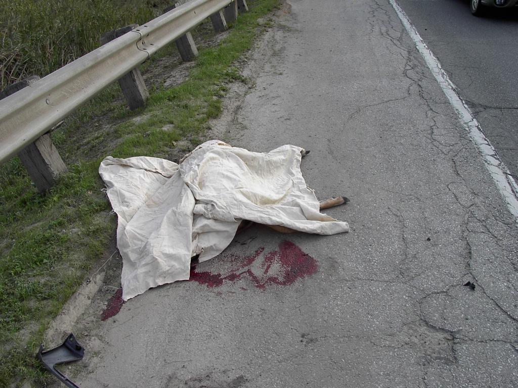
I was travelling along the Bayview extension just south of the Brick Works when I came across this sad sight. A police cruiser, a tow truck, and a battered SUV were also there. Without thinking, I quickly stopped my bicycle and pulled out my trusty camera and snapped this photo. The cop whistled at me. "Hey!" He snarled. "Beat it. I don't need another distraction." So I quickly packed up and went on my way.
A little later on both cop and tow truck pulled into the Brick Works parking lot so I was able to examine the car closely. Both headlights were smashed, along with the front grille and the hood was crumpled. The radiator was pushed in. About $2-3000 of repair work. The driver was shaken up but unhurt.
Apparently the deer was trying to cross Bayview during rush hour. It was very busy. Of course since deer have been spotted in the valley for the past three years, this was bound to happen eventually. A tragic result of the impact that we humans have on the natural environment.
Subscribe to:
Posts (Atom)