Tuesday, August 30, 2005

Cracked!


Along the lower Don are planted a number of trees called Crack Willow (Salix fragilis). This species is not native to Canada but is introduced from England. They produce a dappled shade which I suppose is aesthetically pleasing to some. Fortunately they are not invasive. They are a common park tree and you will find dozens in places like the Toronto Islands.

It gets its name from the sound when its twigs break off which creates an audible pop. In its native range the tree is supposed to have a lifespan of up to 100 years but in Toronto they have an annoying habit of falling over after only about 50 years.

The one depicted here is on the lower Don trail just north of Queen St. East. It didn't fall during the storm two weeks ago but was likely weakened by it. Nevertheless it is the city's forestry department who needs to come by and clean up the mess. Until then trail users will need to pick their way through the limbs.

Monday, August 29, 2005

Don hike shows good and bad sights

I planned to go for a hike yesterday on the Bruce Trail. The Toronto Bruce Trail Club offers bus tours. They rent a school bus which picks hikers up in Toronto, delivers them to the Bruce Trail and then picks them up at the end for the trip back. A good way to spend a weekend day. One of my friends called it day camp for adults. Unfortunately there are no reservations so it is first come first served. When I got to the bus pick up at York Mills the bus was already full. That's the way it goes.


Rather than waste a good hiking day I decided to go on a self guided hike through the Don Valley. I walked down to Lawrence and Bayview and entered the Don Valley at Glendon College. From there I made my way through Glendon Forest to Sunnybrook Park. Glendon Forest is one of the few undeveloped areas left on the West Don. Of course it suffers from the usual problems such as overuse by mountain bikers and dog walkers, and the spread of invasive species but these are nothing special for the Don. It is still a nice place to hike.


After cutting through Sunnybrook Park, I decided to take a look at Wilket Creek. Wilket Creek runs through a narrow ravine that parallels Leslie between Eglinton and Lawrence. At the north end is Edwards Gardens, a manicured valley known for a good place to take wedding photos.


What a mess! The ravine area suffered heavily from the storm two weeks ago. At least one bridge was swept away entirely and two others heavily damaged. In one place the asphalt path was lifted up off the ground like a piece of ribbon and dumped downstream. One meander is now an oxbow as the creek cut itself a new path. The garden area next to the creek is no longer a pristine garden but an ugly rent in the valley. Sod grassed areas have been gouged out, an interlock brick path destroyed, a duck pond now just a muddy hole.


It's going to be awhile before the weddings return to this place. On the upside, Saturday's rain washed most of the flood's crud away so the valley at least looks more presentable.

Friday, August 26, 2005

Deer Zero, SUV Zero


I was travelling along the Bayview extension just south of the Brick Works when I came across this sad sight. A police cruiser, a tow truck, and a battered SUV were also there. Without thinking, I quickly stopped my bicycle and pulled out my trusty camera and snapped this photo. The cop whistled at me. "Hey!" He snarled. "Beat it. I don't need another distraction." So I quickly packed up and went on my way.

A little later on both cop and tow truck pulled into the Brick Works parking lot so I was able to examine the car closely. Both headlights were smashed, along with the front grille and the hood was crumpled. The radiator was pushed in. About $2-3000 of repair work. The driver was shaken up but unhurt.

Apparently the deer was trying to cross Bayview during rush hour. It was very busy. Of course since deer have been spotted in the valley for the past three years, this was bound to happen eventually. A tragic result of the impact that we humans have on the natural environment.

Wednesday, August 24, 2005

Flooding in Taylor Creek Park

One of my varied volunteer duties is webmaster for Friends of The Don East. FODE, as the group is known, concentrates its activities in the Taylor-Massey Creek watershed as well as a few other places that resided in the old borough of East York, their primary base.

Anything that appears on the FODE website usually has to do with that area of the Don. So among my travels to observe the flood damage I visited Taylor Creek Park and took a few pix of the flooding. I wrote a short article to accompany them and posted all this to the FODE website.

Rather than repeat it all on this blog, I am just providing a link to the story.

Enjoy.

Monday, August 22, 2005

High, but not that high


Beechwood Wetland shows signs of inundation. Now we need another rain to wash all the muck off.

I went on a ride down the Lower Don Trail from the forks to the mouth. Most of the trail was covered in water with only a few high spots left dry. Now that the water has receded, everything is covered with a layer of mud and dirt. Beechwood, Binscarth, Helliwells Hill, Chester Springs were all inundated. The lower pond at the Brick Works was part of the river at one point.

What surprised me the most was that the lower part of the river was untouched. There was hardly any flooding south of Queen. The real bottleneck - the Lakeshore railway bridge - showed less than 25% of overflow capacity. All the flooding upstream was a result of localized overcapacity. The berm being built south of Queen would not have even being touched.

The big hope is that flooding such as was seen on Friday will be mitigated by the Wet Weather Flow Management Plan. This 25 year plan started in 2002 will make changes to source and and terminal control points so that when rain falls it doesn't all flood into the valley all at once. The only problem of course is that WWFMP only applies to Toronto. Water flowing from north of Steeles is still uncontrolled. Maybe Markham and Vaughan will be forward enough in the planning to start their own WWFMP's (ha!)

After the storm


While I didn't view Friday's storm personally I did see the news reports of flooding on the Bayview extension. The river was up and still flowing muddy all weekend.

I passed by the mouth of the river late Sunday and took this photo of the mouth from the lift bridge on Cherry St. This is some the debris that floated down the river that was captured by a boom to prevent it from going into the harbour. It looks thick enough to walk across.

This is just one of the issues that needs to be addressed by the Don Mouth EA (See previous post).

Thursday, August 18, 2005

Don Mouth Naturalization Project

It's taken a few years to get fired up but it has finally started. This will be the biggest public works project to impact the lower Don in the next ten years. Basically it will decide how the mouth of the Don will empty into the harbour. Right now the river empties into the Keating Channel, turns 90 degrees west and enters the harbour at Cherry Street.

If you go east from Cherry to the Don Roadway and north to the railway embankment this property is informally called 480 Lakeshore. This area has been reserved for any future work that may include a naturalized marsh and a new channel for the river.

This project requires a full environmental assessment or EA in the vernacular. As part of the process the TRCA is organizing a series of public meetings to create terms of reference for the public. While all these meetings are a bit tedious, they are an important part of the process and it is essential that the Task Force and its supporters attend so we can push our position. That being a naturalized channel and an accompanying marsh. To see a picture of our vision you can view it at http://www.toronto.ca/don/vision.htm.

The next public meeting is on Tuesday Aug. 23 at the Ralph Thornton Community Centre, 765 Queen St East. If you can make it to the meeting, we (the Task Force that is) would appreciate it. All the information you might require about the project can be viewed on the TRCA website.

Tuesday, August 16, 2005

Common Whitetail


Took this picture at the Brick Works a few days ago. I noticed that this dragonfly was flying around in a big circle over the pond but always coming back to rest at the same place on a log near the pond's edge. So I settled in and took a few pictures. This is the best picture, taken from about 50 cm away. I looked up the species and it is called common whitetail (Libellula lydia). This is a male. Females have a darker coloured tail.

Further reading indicates that the naiad or larval stage feeds on mosquito larva and the adult flying version feeds on mosquitoes. The prevalence of dragonflies in the quarry ponds could be one reason I don't get bitten very often when I visit.

Sunday, August 14, 2005

Wetlands are the Best Lands

While I'm not one to toot my own horn very often, I am quite proud of my latest publication. My newest creation is now on the city's website and can be viewed at: http://www.toronto.ca/don/wetlands.htm.

This section expands the old section about the Task Force's restoration sites to include new material on Riverdale Park East, Binscarth Ravine, Nordheimer Ravine, and the Beltline Pond in Moore Park Ravine. While wetlands are highlighted, nearby terrestrial sites are also documented.

I retained the old pages about Riverdale Farm Ponds and Chester Springs Marsh but there is certainly room for updated text and photos. In addition, I am now working on new sections for Helliwell's Hill and the riparian restoration on the Lower Don. Eventually I hope to include a section for the Brick Works even though it is not a site that was initiated by the Task Force.

Saturday, August 13, 2005

Meadow Interruptus

The Task Force to Bring Back the Don has been active in the valley since the early 90's. Busily restoring a variety of degraded sites creating new and improved meadows, forests, and wetlands. However the memory of some of these sites seems to have been lost to certain city staff members. Here's the sad story.


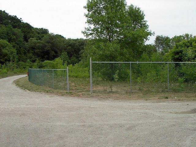
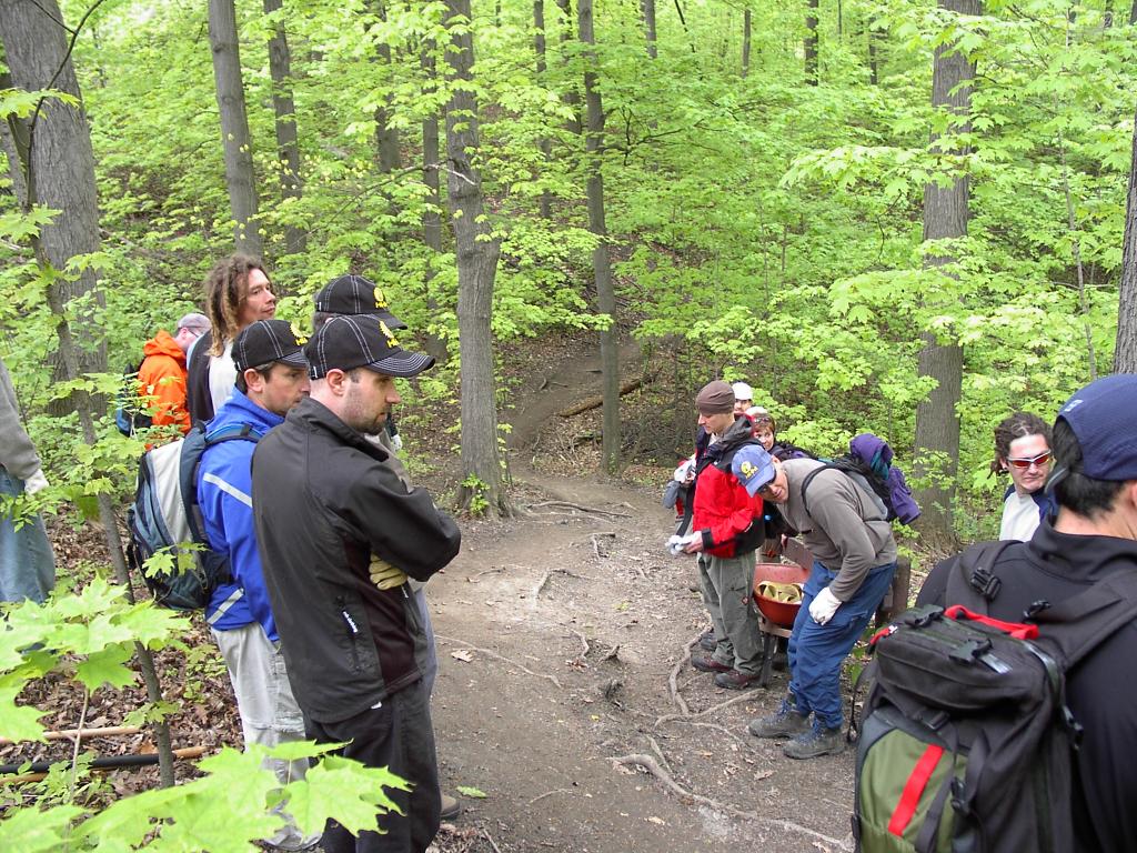
One of the restored sites was a mown grass meadow. The site is at the bottom of the Belt Line trail where it turns into the Roxborough Drive ravine alongside the Bayview extension. In 1994 the Task Force planted the site with native trees and shrubs. Up until quite recently it was maturing as a nice forest edge habitat. Unfortunately something new has sprouted up on the site – a chain link fence.

It turns out that at the nearby Brick Works site the city has been in receipt of a large private donation to create facilities for dog walkers. So two fenced in areas were built in 2004, one of them near to the Brick Works entrance.


“Not good enough!” states the donor, who apparently is also a dog owner. “They need to be bigger.” So the city not wanting to lose the money says “Oh, look, there's a piece of land over here that nobody is using. We can add that to the doggie park.”

What they didn't realize was that this piece of land is our old restoration site and a successful one at that. Before we knew it a fence went up. When we asked what's up with our site? “Sorry, it's a done deal.” says the staffer. “If we don't let this land go to the dogs we're gonna lose the money.”

So is that the end of the story? Not if we can help it. We still have a few friends in the megacity. With a bit of luck and a few twisted arms we can reverse this silliness.


The lesson to be learned here is we can't let up our guard. You turn around for one second and someone takes this as an opportunity to push their priority projects over yours. I'll keep you posted.


Map of contentious meadow


New fence beside Belt Line trail


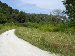
Meadow as it was last year

Friday, August 12, 2005

Deer in the valley

About 30 people attended the Yellow Creek walk. During our outing we spotted a deer just at the edge of the Mount Pleasant Cemetery. I have seen deer for the past three years but this was a first sighting for some of the hikers.

It was too far away to see but it looked like an immature female.

Friday, August 05, 2005

Yellow Creek Walk

For anyone who wants to get out of the house on Sunday, here's an opportunity. Peter Hare and I will be leading a walk along the route of Yellow Creek, one of the so-called lost rivers of Toronto. For anyone who doesn't know, about a dozen small creeks coursed through small ravines all over downtown Toronto. Now most of them are buried in storm sewers. Peter Hare and the North Toronto Green Community have created a very interesting eco-historical website that details the routes of these former creeks and the local history behind them. You can view the website at:

http://www.lostrivers.ca/

Our walk is on Sunday, August 7, starting at 2 PM at the entrance to Davisville subway station. The walk is free and suitable for all walkers. Should last about 2 hours.

Thursday, August 04, 2005

Mountain bikers and their stunts

Recently the city went into Crothers' Woods along the trail frequented by mountain bikers and removed some trees that were potential hazards. Incidental to this, some stunts that were attached to these trees were also removed.

The mountain bikers complained loudly and at length about the travesty of it all. My complaint is not so much the about the city's initiative but about these whiners.

Let me illustrate this. Let's say you are a homeowner. Someone comes along and builds a swing on a tree in your backyard without your permission. Every so often someone comes along and uses the swing again without your permission. You decide you don't want anybody using this swing so you decide to remove it. Then to your surprise, the swing builders knock on your door and complain loudly that you destroyed their property. Most people would agree that the homeowner is well within their rights to choose what to do with their property.

The
same is true for Crothers' Woods. The city is the landowner and they are well within their rights as the property owner to control the uses put to their property. Granted the city is a public institution and is governed by slightly different rules but the analogy is largely intact.
What really bugs me is that the mountain bikers are whining yet refuse to organize properly to do anything about it. They want to have their cake and eat it too.

Fortunately the city is taking a longer view. There are still some forward thing bikers out there and with the city's help and training they are starting to make a difference. They are replacing badly made trails with sustainable use trails, trails that will last. While the new trails may not impress some extreme riders they are making them usable for the majority of the riders.

Some people complain that this process is taking too long but it might actually go faster if whiners turned into workers. Deeds, not words is a motto that they should learn.

If you are interested in joining one of the trail care crews send an email to Keri at kmcmaho1@toronto.ca. They meet once a week on Wednesdays to work on the trails.


Trail crew ponders piece of bad trail


Restored forest after trail reroute

Monday, August 01, 2005

A breath of spring


Trillium erectum (red trillium)
One of my favourite pictures this year. Taken in a remote part of E.T. Seton Park on the West Don in May. It's too bad that untouched beauty is just that. Too often I see people carting wildflowers out of the valley for some personal fleeting pleasure. Why can't they leave them alone for everyone's collective appreciation?