Friday, July 25, 2008

Honey Bee Security Guards


Warning sign

The Brick Works building complex has been derelict for close to 30 years with only one or two of the smaller buildings being reused. The larger buildings have remained empty and unused. This neglect has attracted all sorts of unwanted visitors. They've been a magnet for many novice and professional photographers who specialize in industrial settings. There has also been weekend raves and explorers of tunnels and abandoned places. The insides are filled with graffiti and garbage.

When I was on the Brick Works Public Advisory Committee (now disbanded), I advocated for a security guard presence to deter visitors. After much delay we ended up with a once nightly visit from a security guard who only drove into the front parking lot. This did little to reduce problem visitors.

Today when I visited the Brick Works I noticed a sign on the fence outside the Chimney Court. Inside was a collection of beehives. I don't know if they will prevent people from entering the buildings but the prospect of a bee sting may force potential visitors to think twice before entering. It sounds like a win-win solution - the honey bees pollinate flowers at the Brick Works, they deter unwanted visitors, and they produce loads sweet tasting honey.


Honey bee hives clustered next to honeycomb painted hut. The hut looks awfully similar to the ones constructed by the Holmes on Homes show that was filmed at the Brick Works last year.

Wednesday, July 23, 2008

Erosion Control Update 3


Site A embankment in good shape

I visited the Erosion Control Site on July 7. It is now into July and no further work has been done. Admittedly, July is usually a period where there is less rain and this July is on track to become one of the wettest on record. Unless August starts being a lot drier it may be September or October before the work gets done on Site B. The main problem is access to the downstream site requires a temporary river crossing to be constructed. This can't happen if the river is flooding once per week.

As to the completed work I noted a few observations. The dogwood and willow twigs that were placed in the Site A embankment have actually sprouted leaves. At least one of them has produced flowers. The bank itself has held up well even after some moderately heavy rainfalls. Debris in places shows that water levels have come about halfway up the bank.


Dogwood cuttings (Cornus spp.) are sprouting vigorously


Debris litters the embankment which indicates that recent storm events have pushed water levels halfway to top of bank.

At the downstream end the river is doing something interesting. Adjacent to the rock lined area is a clay embankment. The river has started to scour this heavily, eroding it faster than just further downstream. Water may be speeding up as it passes over the rock creating an eddy as it leaves the rocks and hits the natural surface. This may require some additional bank tinkering to reduce this effect.


Clay embankment shows additional scouring at downstream end of Site A

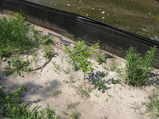
Some plantings have been done at the top of bank. The plants are looking a little forlorn since any mulch has washed away. Some additional maintenance may be required although they have certainly been getting enough water. The adjacent railway embankment is a total loss in that it is completely covered with Dog-strangling Vine (Cynanchum rossicum). Some serious treatment regime is needed here or the restoration will be overwhelmed by DSV in a few years.


Some plantings have been done as part of the restoration plan.

Dog-strangling Vine accounts for about 95% of the ground cover on the railway embankment.

Tuesday, July 22, 2008

Brick Works Plumbing Problems


Situation map


Water coming from base of hill. What is the source?


Water flowing south down path toward front parking lot.

As early as 2001 I noticed that a torrent of water spewed out of the ground at the southwest corner of the Brick Works Quarry Ponds Park after a heavy rainstorm. The water's source was not readily apparent as the hill directly above it was completely dry. It wasn't until recently that I found the source.


June 23 - water overflowed gully

July 22 - dry gully. Culvert is below railing in middle of photo (click to see detail)

On June 23 I was taking pictures in the vicinity of the Brick Works and noticed this problem re-occurring. I went up the hill on my way to take pictures of another situation when I noticed to my amazement that the off-leash dog area was now a lake! The water was ponding in this area to a depth of more than 3 metres from the bottom of the Mud Creek gully. During the storm the culvert where the water goes underground must have become plugged and all the storm water filled up the depression in response.


View of the culvert. Toronto Water has removed debris from the culvert that was causing the blockage (pile of debris to left of culvert).

Somehow this water was starting to leak into the Quarry Garden below. I am not sure of the exact path but the dotted line on the map shows the direction that the water may be taking.

I am fairly certain that these two situations are linked. This problem needs to be addressed at some point. As with most underground problems the fix will be complex and expensive.

Sunday, July 20, 2008

Signs of Flooding

Since June 23, the Don has experienced at least four heavy rain events. As you know from previous years, the Don doesn't respond very well to large amounts of rain. Here are a few pix from some of the recent storms.


Mud Creek culvert before...

...and after

On June 23, I was cycling through the Moore Park Ravine and took a few snapshots. I stopped for lunch and was caught by a torrential downpour. Nearly 30 mm of rain fell in about 1 hour. After the rain stopped I went by the same spot and took another photograph. You can see that there is a lot more water and more debris after the storm.


June 23 - view from Beechwood Drive bailey bridge

July 3 - same place on a dry day

Another comparison shows you the volume of water that flows through the Don after a storm.


Footbridge in Wilket Creek ravine

On July 7 I went through Wilket Creek ravine and noticed several places where the path was damaged from recent flooding. This bridge is particular was totally choked with woody debris. The adjacent path shows signs that the water became dammed and started to flow around the bridge, washing away the asphalt.


Bicycle path in E.T. Seton Park

I took this photo near the construction site where they are rerouting the river. Note the damaged asphalt on the path. Also note leaves stuck in the fence next to the path. This is a sign that water flowed here once. At first I thought that the water was high enough to place the leaves here but considering the light damage to the path, what probably happened was that the flood waters tipped the temporary fence over on its side and it was later put back up again.

Monday, July 07, 2008

A Small Stormwater Issue


Log hung up on bridge


A week later

On June 23rd there was a violent storm that dumped a lot of rain on Toronto. Much of it ended up in the Don. Among many examples of flood related damage was a log hung up on the footbridge crossing the river just north of Riverdale Park. The water was high enough that a log was caught in the railing of the bridge and got stuck against the bank.

While not an immediate problem, if left untouched it could have started a log jam and caused further damage to the bridge. I took some pix and sent them off to the parks supervisor. Today I noticed that the log had been cut down from the bridge. The log is still in the water but it will be safely washed downstream during the next flood.


Location of bridge