Monday, October 30, 2006
Bike Hike 2006
Route of the hike (click to enlarge)
On Saturday, October 14, I led a hike through the lower Don. It was cosponsored by the Task Force to Bring Back the Don and the Toronto Bruce Trail Club. 30 people attended the hike, even though the Weather Channel was calling for a 70% chance of rain. It did in fact rain briefly late in the day but for the most part it was cloudy with a few sunny breaks. It was a little windy at times but when the sun came out it was a fine autumn day. As these pictures attest the fall colours were stunning proving once again that you don't need to leave the city to see good fall scenes.
Starting at Broadview Subway Station, I led the hike through Todmorden Mills, then up along the biking trails that thread there way through Crothers' Woods. In E.T. Seton Park, we went along a trail nicknamed Party Atmosphere, a technically challenging trail for both hikers and bikers. The last part of the hike went through Serena Gundy and Sunnybrook Park. We then followed the paths beside Burke Brook walking through Sherwood Park and Blythwood Ravine.
The hike started at 10 AM and ended around 3:30 PM with a 25 minute break for lunch. In total the route was about 15 km long. This remains one of my favourite hikes in the valley and I will be doing this one again in the future.
Crossing at the mouth of Walmsley Brook
A view of the valley looking east towards Flemingdon Park
Negotiating a bridge on Party Atmosphere. Ok for bikers but a little steep for walking
Hiking along the trail
Dave Tyson, my backup hike leader
Wednesday, October 25, 2006
Clean, Green, and Accessible
The Task Force to Bring Back the Don has been doing alot of navel gazing recently. Over the past year or so the Task Force has considered the Bridgepoint Health Centre (formerly Riverdale Hospital) development plans and what to do about it. One member, let's call the person Leslie (now there's an androgenous pseudonym), in particular has been very vocal in opposition to these plans. In the end the Task Force voted to not take a position on the development plans, a tacit support I suppose.
Leslie of course was very unhappy with this turn of events and continued to voice disapproval. Leslie said, "IMO, the Bridgepoint proposal doesn't fit with my interpretation of the Task Foce slogan of 'Clean Green and Accessible'. But what does that slogan mean? It's very much open to interpretation. Let's try to nail down a more precise definition. I am sure that if we get it right, it will provide a clearer guideline to future Task Force members on how to approach future proposals like Bridgepoint. That way it will make things easier to make decisions, maybe even create a checklist which we could use to evaluate future proposals to determine if they fit or not. " We said, "OK, Leslie, maybe you're right."
So, over the past 9 months we have discussed, argued, and wordsmithed a longer description of just what is meant by 'Clean, Green, and Accessible'. In the end we produced a document that we could pretty much agree on. But what do we do with it? Do we enshrine it as part of our Terms of Reference? Or just keep it as a position paper? My opinion is definitely with the latter.
The Task Force does not have permanent members. We get reappointed with every term of council. Old members quit, they move out of the city, they get burned out or they simply lose interest.New members get appointed to replace them. Some of us do hang around for multiple terms but that accounts for only about 1/3 of the members. The Task Force has existed for about 5 terms of council and each one has been slightly different. Each citizen member brings his or her own set of qualities and interests and the collective sum has produced a slightly different flavour of doing things. IMHO, it doesn't make sense to try and impose our own world view on future Task Forces because they will likely be different than the current version. So the decision was to leave it as an internal document to be used as an orientation for Task Force members of the future.
Don't get me wrong. From my point of view all this internalizing was a useful exercise. "Clean, Green and Accessible" to me has been a catchy marketing slogan. Now if somebody asks, what do you mean by that? Well now I can whip out this document and say "Here is good description. Take it as you will."
P.S. I was hoping to post the text of the document but it's kind of long so I will save it for a future post.
Monday, October 23, 2006
Beaver at the Brick Works
Signs of beaver damage
Aha! Who might that be resting in the reeds?
Beaver swimming in the pond
I visited the Brick Works last week and discovered that there has been some tree damage. Upon closer inspection it appeared that it was the work of a beaver. Beavers have been spotted periodically in the Don for several years but the lower Don Valley doesn't provide enough habitat for them yet. They like low lying flat areas with slow-moving creeks so they can build a dam and create a small pond. Unfortunately there aren't too many place like this in the Don Valley. Most of the creeks are in ravines that are too steep and when it rains the flood of water is just too great and too polluted for beavers too cope.
The Brick Works might be suitable but there are too many people and (off-leash) dogs around that makes them skittish. Usually they just visit a place, chew down a few trees and then move on which I think has happened to this guy. After the first day that I saw him, I haven't seen him again.
It's good to see that habitat has improved enough to attract beavers but not quite enough to allow them to take up residence.
Thursday, October 19, 2006
Brick Works Petitions
Evergreen's plan for the Don Valley Brick Works seems to have as many supporters as it does detractors. One of the more prominent detractors is Tim Trow who is currently head of the Toronto Humane Society. He has started a petition to raise support to stop the Evergreen plan from proceeding. What he plans to do with the petition or who he is going to deliver it to is unknown.
Trow may have his own private agenda here. He happens to be a local resident and is likely part of the group of Rosedalers who would like to keep the Brick Works as their own private doggie park. He views the plan as bringing an unwanted level of activity that would disrupt his enjoyment of the site.
Trow also has own set of detractors. Not everyone is happy with the way things are being run at the THS. There is some perception that the place isn't being run with the animal's best interests in mind. To that end there is another petition that seeks to get rid of Tim Trow as head of the THS.
It's unlikely that anything will come of either of these. Both petitions will probably end up in the electronic trash bin.
Tuesday, October 17, 2006
Garbage: Here Today, Gone Tomorrow
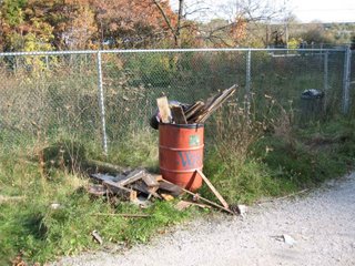
Dump site
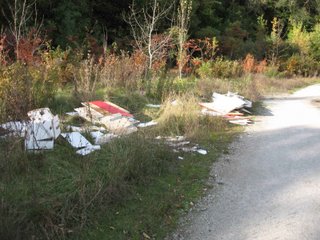
Construction debris
Looks like somebody's former kitchen cabinets
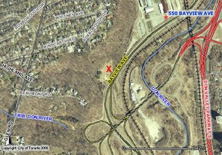
Last Sunday as I was leaving the valley after the trail work, I came across this mess. This is right beside the unwanted dog run (that the city still hasn't fixed but that's another story) just southwest of the Brick Works. There is a gate off Bayview Avenue that accesses a service road for an Enbridge gas pipeline building. It was originally blocked by a metal post locked to the ground but this has gone missing. This allows anyone access to this small secluded field 24-7. Somebody took advantage of this and dumped a load of construction waste, some kitchen cabinets, old tires, empty propane cylinders and some rotten wooden boards.
I took these pictures and sent them to the city parks staff. I expected to wait awhile but much to my surprise they were cleaned up by Monday evening. I was talking to the Bob Ward, the parks supervisor and he thanked me for sending him the pictures. He blames the open gate on another city department (those darn silos).
Anyways it's good to see at least something taken care of promptly.
Sunday, October 15, 2006
Trail Improvements
Pottery Road trailhead is crowded with uses and proposals (click to enlarge)
Accommodating a diverse range of uses in natural areas is a complex task, but it is one where the city is making some headway. In the case of the Don Valley it is trying to manage the needs of mountain bikers and other trail users while also seeking to enhance the ecological function of the valley, something that has been severely degraded in the past.
Over the past 15 or so years, mountain bikers have adopted a series of trails through the Crothers' Woods area of the valley. Unfortunately unmanaged use has not always led to good trail design. Case in point: just north of Pottery Road where it meets Bayview Avenue is an access point for these trails. The ground rises sharply and the first trail to be built went straight up the side of a hill. While this was a quick route it became gullied and eroded as rainwater slowly ate away at the ground. There are now two trails because the first one became unusable. Left unattended these trails would eventually become unusable even for hikers.
Fast forward to the present. The city is now working with the International Mountain Biking Association, or IMBA for short to build a set of trails that will last. Over the past month they have been rerouting the trail so that it runs along the contour of the hill. This type of trail design allows rainwater to flow quickly off the trail and keep it dry.
Volunteers, mostly from the biking community, have been trained on trail construction. Over the past three years they have been slowly fixing the worst spots on the trail. The Pottery Road trailhead is just the latest phase of a long project to improve the trails all the way north to E.T. Seton Park.
Hikers and bikers alike have been hugely appreciative of the efforts by these volunteer trail workers and they should be lauded for their efforts.
The Task Force to Bring Back the Don has also had its eye on this site for a long time as the location of a proposed wetland. Cudmore Creek cuts through this site and the regular flow of water creates the potential for an expanded ecological function. Most of the wetlands in the Don have been lost due to development and places to create a new one are few and far between.
For one reason or another the wetland project has been delayed. In the interim, the parking lot was created, originally as a construction lot for a hydro project but has since been adopted by the mountain bikers. The wetland proposal is still outstanding and may eventually be built which should enhance the ecological value of this area.
With proper management, human uses can coexist with the natural environment. The city is now looking to develop an overall management plan for this section of the valley. On November 1st, they will hold the first in a series of workshops that will give interested users and the general public a say in how this plan is created. Details of this meeting will be posted here when they become available.
Old trail goes straight down slope which is bad for water drainage.
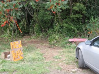
New trailhead at edge of parking lot
The new contour hugging trail winds through a sumac grove
New trail already in use
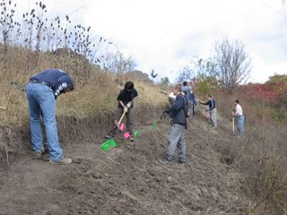
A work party continues the trail work. The volunteer in the middle is wielding a Pulaski. It's a pick axe that can also be used for digging. It was adopted for trail work from its origins as a forest fire fighting tool.
This tool is called a Macleod, a versatile tool for cutting, hoeing and compacting.
Using the Macleod for broadcasting dirt away from the work zone.
One of the trail crew has posted a Flickr slideshow of Sunday's trail work.
Monday, October 09, 2006
Dog Walker Escapes Brush with Darwin Award
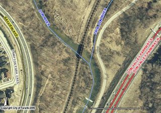
Railway bridge crosses the Don River about 500m north of Pottery Rd.
Late Sunday afternoon a 20 year old man walking his dog (unleashed) along the CNR tracks was hit by a passing freight train north of Pottery Rd. As reported in the paper and TV news, The dog ran onto a bridge crossing the Don River. By the time the man caught up to his dog it was too late to leave the bridge as a train just happened to come by at the wrong time.
Both man and dog survived the incident but the stupidity of the incident just blows my mind. First, this wouldn't have happened if he had been walking his dog with a leash which is required by law. Second, running onto a railroad bridge without first looking for a train is just looking for trouble. Trains go by here all the time on no fixed schedule so you have to be constantly vigilant.
If he had killed himself that he would have received a free nomination for the Darwin Awards.
Update on Tree Seed Pod Post
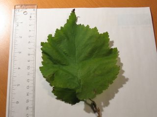
Leaf from Hazelnut tree (with strange seed pod)
I revisited the tree where I found the unusual seed pod (see previous post). I took a sample leaf from the tree, depicted here. It is approximately 16 cm long and 12 cm wide. This was one of the larger leaves, there were smaller leaves as well. The leaves are alternately placed on the stem.
Thanks to Alan S. Weakley, Curator of University of North Carolina Herbarium in Chapel Hill who helped identify it as a European Hazelnut tree (Corylus avellana) . It is located in a Taylor Creek Park so it was likely planted there on purpose by the old East York Parks Department that managed the park before amalgamation. Toronto has since become more careful about planting non-native species in the natural areas of the city.
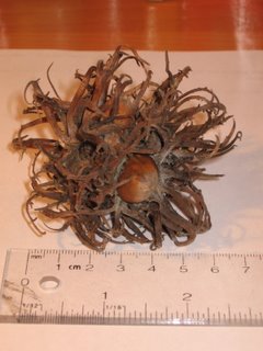
The seed pod has an unusually long woody bracts that might be caused by a virus, or it could be a cultivar of the tree that normally produces this type of seed pod, I am not sure at this point. Still it is an unusual tree.
Thursday, October 05, 2006
Unusual Seed Pod
I led a hike last Saturday following the entire length of Taylor-Massey Creek, about 16 km. It was attended 15 people, mostly Bruce Trail regulars. The low turnout may have been due to the threat of rain although it held off until very near the end.
In Taylor Creek Park we came across some unusual trees with leaves shaped like birch or cottonwood. However they produced a very bizarre looking seed pod (see picture). It is about 7 cm in diameter with curly woody spines sticking out all over it. Imbedded in each pod are about 5-7 seeds that kind of look like hazelnuts. I looked it up in my Trees in Canada book but I couldn't find an equivalent so it is likely non-native. If any tree experts out there have a clue, let me know.
Unknown seed pod. Can you identify it?
Monday, October 02, 2006
Nordheimer Interpretive Signs (Finally!)
Last year the Task Force to Bring Back the Don hosted a series of educational workshops to tell people about the affects of rainwater on the city and what they could do to reduce its impact on our ravines and valleys. Among other things we got funding to create interpretive signs for four sites, two of them being in the Nordheimer Ravine.
Believe it or not, it took over a year to get the funding, design them, construct them and get them installed. Initially we got funding from the Toronto and Region Conservation Authority. However since they were being installed in a city park, the city's communication department had to sign off on the text. This is where most of the delays occurred. We lost count the number of times we submitted drafts of text to them and they would return it with corrections. At least twice they changed the species name even though we had given it to them and told them "Don't change this". Arrgh! In a previous post I mentioned that the government bureaucracy was one of the five biggest threats to the restoration of the Don. This is but one small example.
So after what seems like an eternity, the interpretive signs we order are now installed. Ironically, the money for the signs came from a grant from the TRCA to the Task Force. We gave it to the city to build them, but we had to give them back to the TRCA who did the installation.
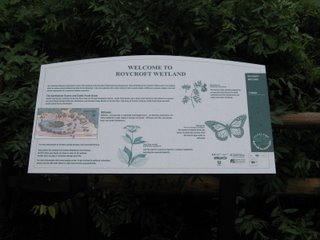
Of course no one told us they had been installed, I just happened upon them on one of my regular tours. I took a close look. In the bottom left hand corner are seven logos of all the companies and government departments that had a hand in the funding. It's darkly humorous to note that each of them is named except the Bring Back the Don fish logo. After all the trouble, hassle, and frustration we went through to get these installed, we can't even get our own name on the sign. Screwed again!
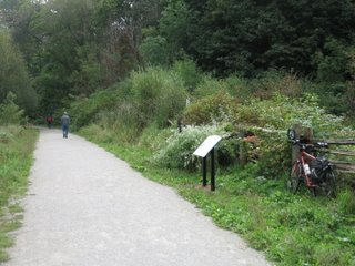
Still I shouldn't complain too much. They are now installed and they do look nice. The sites themselves were created in 1998 and since then they have done so well that it's hard to actually see the ponds anymore as the trees, bushes, and rushes now obscure most of the water.
If you haven't visited this park you should. It's one of the nicest mid town ravine parks that meanders south east from St. Clair West subway station for about 1 km. Lost Rivers has a good map of the area.
New sign for Glen Edyth Wetland
The Glen Edyth wetland (my trusty steed is on the right)
Roycroft Wetland sign
Path next to Roycroft Wetland
Subscribe to:
Posts (Atom)