Sunday, November 06, 2011
Getting to the Brick Works from Pottery Road
Three possible routes: red, green, and yellow (see below for descriptions)
The Don Valley Brick Works has undergone a transformation in recent years and has opened up under the care of Evergreen Canada as the Evergreen Brick Works. Evergreen has done a masterful job of restoring the buildings and updating the site for multiple uses including a farmer's market, a native plant nursery and a skating rink in the winter. The place is worth a visit.
Unfortunately access other than by car has been and continues to be a challenge. The TTC runs a bus there but only on Saturdays. The 28A Davisville bus extends its route to the Brick Works 8AM - 6 PM. Evergreen offers a shuttle bus from Broadview subway station that travels every 20 minutes between 7 AM to 7 PM (4:30 PM on weekends). Access routes by foot and by bicycle remain difficult and at times safety-challenged.
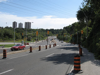
Improved intersection at Bayview Avenue includes a new pedestrian crossing on the north side
Recently the city has done a complete makeover of Pottery Road. It was supposed to re-open September 5 but due to issues with an unstable slope it remains closed until November 30. Fortunately, there is safe access for pedestrians and cyclists to make it through. In addition there is now a pedestrian crosswalk (with a crossing button on both sides) at the intersection of Pottery Rd and Bayview Ave so this is definitely a positive step forward.
Therefore it makes sense to review the access options to the Brick Works from Pottery Road. If you look at the map, there are three possible routes. Based on colours I will describe each route and their pros and cons.
Red Route
Path up side of hill. Ravine access road is just to the right (don't go that way)
From the intersection at Pottery and Bayview, cross at the lights and turn right (north). Go up the hill a short distance. When you reach a park access road that winds up through a small ravine to the north west, you will also see a dirt path going up the hill to your left. This path is very steep and can be slippery in wet conditions but can be managed with care. I don't recommend this route for any cyclists except those with good mountain bikes. At the top of the hill you will find a railway. It's OK - currently it is not in use and there are even small trees growing through the ties. Cross the tracks and scramble up a short steep embankment and this will bring you into the north east corner of the old quarry.
View of Brick Works ponds from the top of the slope
The top edge offers one of the best views of the quarry ponds. There is a dirt road which goes south and this will lead you to the north edge of the Brick Works complex. While going down the winding gravel road you will see a climbing tower built by Outward Bound, one of Evergreen's tenants. You can also take a detour to a lookout or scramble down the slope on one of the informal paths that lead into the pond area.
Green Route
Median is about 2m wide but only a painted line separates you from traffic. Be careful!
From the intersection at Pottery and Bayview, cross at the lights and turn left (south). Follow the paved median beside Bayview. This can be a bit unnerving because traffic comes up behind you at quite a clip. The speed limit on Bayview was recently reduced from 70 kph to 60 kph but this doesn't make you feel much safer. As you continue along around the corner you will notice a new access road that gets you into the back parking are of the Brick Works. At some point there will be Jersey barriers placed along this route but until then care must be used here. This is the shortest access route and is usable by both walkers and cyclists.
Yellow Route
Start of Yellow Route trail
This route starts immediately on the west side of the CN railway crossing. Getting to this point is the hardest part because you must cross two lanes of traffic with no aids other than your wits. When you cross the river, the only pedestrian access is on the north side so you need to cross the tracks and then scoot across the road (there has been talk of building a pedestrian bridge on the south side but this will be sometime in the future when gravy stops flowing down the Don River). Care must be used at this point. Once you make it across Pottery Road, this route turns out to be the nicest of the three.
Trail runs close to railroad so be careful
The informal path here follows a route between the railway tracks and the road. Safely ensconced between road and rail the path allows for mostly single file passage almost all the way to the entrance of the Brick Works. The path exits onto Bayview about 25m east of the lights. Fortunately a newly installed pedestrian activated button allows for easy crossing of Bayview. This route was recommended by me as the preferred route but unfortunately due to a point where it narrows near a rail installation, the city wouldn't go for it.
So there you have it. Recent changes make for easier access. Eventually the Green Route will be improved. Until then you can choose your preferred route based on your own comfort level.
Sunday, October 30, 2011
Peek at the Creek
On Wednesday November 2, 7PM at the Stan Wadlow Clubhouse, Councillor Janet Davis will be hosting a community meeting to discuss recent and proposed changes for Taylor Creek Park and the East Don. This should prove to be an informative meeting for anyone interested in the Don Valley.
Note about directions: Listed as 373 Cedarvale Avenue, Google Maps shows this address at the corner of Cosburn and Cedarvale. The arena is on the corner. The clubhouse is actually further up the street just north of the arena down a short roadway. See you there!
Wednesday, October 26, 2011
Milkman's Lane Closed
Just north of Castlefrank Subway station is a secluded but well used path that provides a way down into the Don Valley. From the bottom of this path you can access the Don Valley Brick Works and the Belt Line path. How Milkman's Lane got its start is something of a mystery but local legend has it that when milk was still delivered to homes in the morning, this path provided a back entrance for milk carts for the tony neighbourhood of Rosedale.
Regardless of its origins, this well used access path is under severe stress. Whenever it rains, water sluices down the middle of the path creating deep furrows. This creates a hazard for both cyclists and pedestrians as they try to navigate the path.
This fall the city has decided to do some repair work. A new path will be constructed. When completed, the path will be raised in the middle with drainage ditches on the side to collect runoff. Cedar rail fencing will delineate the path but also limit dogs to the path to protect the fragile forest slope on either side of the path. In addition, informal paths that lace the nearby slopes will be closed off to allow for natural forest restoration.
The path is set to reopen, barring unforeseen delays due to weather or site problems, by mid-December 2011. For further information on this project see this page on the city's website.
Milkman's Lane
Rain runoff is creating deep gullies in path
Thursday, October 20, 2011
Pottery Road to Open by November 30
Unstable retaining wall on Pottery Road
Word has it that Pottery Road will be reopened for road traffic by November 30. The problem was due to an unstable retaining wall that was due to the fact that they cut away too much of the slope behind it which led to the possibility of the slope collapsing. The retaining wall as constructed would then have failed.
A engineering solution has been chosen. I don't whether it is a strengthened wall or some sort of slope stabilization (or both) but it should be complete in a month. Work on the rest of the road is nearly complete. In the meantime, the pedestrian/bike path is still usable. I advise caution in its use as construction activities are still on-going.
Tuesday, October 11, 2011
Relic of ParticipACTION
Old ParticipACTION fitness station
If you're going through Taylor Creek Park you may notice this odd set of stumps painted a faded green. Behind it is a single tall post painted the same colour. If you didn't know what it was you might think, maybe an unusual rest stop or maybe some strange outdoor urban art. Yet for those who have been around awhile, you'll recognize it as a relic of a moribund fitness program created by a Federal government initiative entitled ParticipACTION. This program which was started sometime in the late 70's (and apparently is still active) was created to try and get Canadians more physically active. In a few Toronto parks they created a series of fitness stations where you would do a series of calisthenics You were then supposed to jog to the next station. The post at the back had a sign mounted at the top to demonstrate the exercise. Presumably this station was for some sort of leg exercise.
It seemed like a good idea but it never caught on. These installations were put in place way before there were any fitness clubs. Nowadays, people workout at their company or at the neighbourhood gym. Fitness in parks is relegated to walking the dog or riding bicycles. Now we're left with a series of rotting relics. How quaint.
Wednesday, October 05, 2011
New Wetland in Taylor Creek Park
New wetland under construction
The Taylor Creek Park ravine is blessed with several areas of natural water discharge which has created marshy areas at the bottom of both sides of the ravines. These manifest themselves as cattail covered wet areas that are not too interesting from either an aesthetic or ecological perspective. One step up from a cattail fen is an open water pond. Ponds have a much greater diversity potential allowing habitat for mammals, birds, and amphibians. Since this ravine has been highly modified by human activities over the past 100 years, all of the natural ponds were filled in. From a natural environment perspective it makes sense to improve habitat by recreating them.
This has recently occurred just west of the O'Connor Bridge. A new wetland has been excavated in one of the cattail fens. The area is covered in natural water that flows into the nearby Taylor-Massey Creek. It doesn't look like much now but by next year this time it should look more like the new wetland further up the valley.
Mallard duck checking out the new pond
Monday, September 26, 2011
Pottery Road Open (for Bikes)
Pottery Road closed at Broadview Avenue
A recent article in the Toronto Star highlighted the recent makeover of Pottery Road which apparently isn't going all that well. Apparently the slope behind a new retaining wall is unstable and they can't guarantee that it won't collapse so they've put the reopening on hold until they figure it out.
While the article said that car traffic is disrupted, they neglected to mention that the new bicycle/walking path is complete and fully available for use. A sign at the top of the hill says the path is closed but you can safely ignore it. The path which is separated from the road by jersey barriers is about 2m wide and fully paved. Caution is still warranted as the railing on the hill side hasn't been fully installed.
So too bad about cars but cyclists and hikers can rejoice!
Sidewalk sign says closed, use other sidewalk but there is no other sidewalk (hint: ignore sign)
Looking down the hill - brand new pavement
Looking up the hill. Retaining wall in question on the left
Wide path beside road. Todmorden Mills on the right, Fantasy Farm on the left
Expanded path underneath the DVP
New connection to Lower Don trail
Intersection at Bayview now includes a pedestrian crosswalk. The other side leads to an narrow paved median which can be used (with caution) to access the Brick Works.
Another view of the intersection at Bayview
Thursday, September 15, 2011
Leaside Spur I: Orphan Trail Needs Linkages
Map of the spur (the image is a little small. Click on it for larger image)
Legend:
Up until now it has seen little use other than the occasional neighbourhood dog walker. But recently it has been resurrected as a possible part of the mayor's vision to create a city wide network of off-road trails.
A recent article in Grid TO prompted me to go take a look for myself. Here is what I found. From the southern start north to Bond Road the trail has been covered with a new layer of gravel, likely in preparation for a layer of asphalt. There are three places where it intersects with existing trails and circles of brick have been placed there to demarcate the crossing. At Lawrence Ave. East a new signalled crossing has been constructed although it is not yet in operation.
The new trail construction ends at Bond Road.
North of this point the trail continues but it is in the same state as the original walking trail. It is still covered in loose stone and cinder block that makes walking difficult let alone cycling. The trail ends again where it meets the CN main line just where it leaves the Don Valley on its way north to Richmond Hill.
There's more to this story than just these pictures. In a second installment I'll look at planned and proposed uses for this trail.
South end of trail (#1). Beyond fence is CP rail main line that crosses Eglinton Ave. East just east of Leslie St.
Informal trail leads to one of the properties on Leslie Street. The trail continues on the other side of the tracks
Just north of the informal trail you can see a remnant of an old spur (#2)
Last remaining track beside warehouse that is now used by Canadian Tire.
New crossing at Lawrence Ave. East under construction (#3)
Trail intersects with another path (#4) that leads to Talwood Park (to the west) and Duncairn Park (to the east)
New surfacing to end at Bond Road (#5)
Trail continues north of Bond Road. Note loose gravel surface that was hard to walk or ride on
North end of rail path (#6). Beyond is the CN rail main line
York Mills bridge across tracks can be seen to the north (#7)
Legend:
- south end of the trail
- informal path and remnant track
- crossing at Lawrence Avenue East
- crossing at Tallwood Park
- crossing at Bond Road
- north end of trail
- York Mills Road
Up until now it has seen little use other than the occasional neighbourhood dog walker. But recently it has been resurrected as a possible part of the mayor's vision to create a city wide network of off-road trails.
A recent article in Grid TO prompted me to go take a look for myself. Here is what I found. From the southern start north to Bond Road the trail has been covered with a new layer of gravel, likely in preparation for a layer of asphalt. There are three places where it intersects with existing trails and circles of brick have been placed there to demarcate the crossing. At Lawrence Ave. East a new signalled crossing has been constructed although it is not yet in operation.
The new trail construction ends at Bond Road.
North of this point the trail continues but it is in the same state as the original walking trail. It is still covered in loose stone and cinder block that makes walking difficult let alone cycling. The trail ends again where it meets the CN main line just where it leaves the Don Valley on its way north to Richmond Hill.
There's more to this story than just these pictures. In a second installment I'll look at planned and proposed uses for this trail.
South end of trail (#1). Beyond fence is CP rail main line that crosses Eglinton Ave. East just east of Leslie St.
Informal trail leads to one of the properties on Leslie Street. The trail continues on the other side of the tracks
Just north of the informal trail you can see a remnant of an old spur (#2)
Last remaining track beside warehouse that is now used by Canadian Tire.
New crossing at Lawrence Ave. East under construction (#3)
Trail intersects with another path (#4) that leads to Talwood Park (to the west) and Duncairn Park (to the east)
New surfacing to end at Bond Road (#5)
Trail continues north of Bond Road. Note loose gravel surface that was hard to walk or ride on
North end of rail path (#6). Beyond is the CN rail main line
York Mills bridge across tracks can be seen to the north (#7)
Wednesday, September 14, 2011
Back at it
This year I've been busy with school, work, and home renovations. This has left little time to go exploring in the Don. However, lots of things are still happening and I plan to get back into blogging all about it.
Sunday, June 26, 2011
Duncan Creek Improvements
EA Notice
The City of Toronto has initiated a Class B Environmental Assessment regarding restoration plans for Duncan Creek. This is a small tributary of German Mills Creek. The open part of the creek runs from Don Mills and McNicoll northwest to just east of Leslie and Steeles. It runs through a shallow ravine bordered by a pedestrian/cycling path.
There will be a public open house on July 11, 7-9 PM at Cummer Park Community Centre which is at 6000 Leslie St. (SW corner of Leslie and McNicoll).
The full notice is available on the city website.
Wilket Creek Channel Improvements
Notice
The Toronto and Region Conservation Authority hgas initiated a Class B Enviornmental Assessment regarding improvement to the stream channel within the Wilket Creek ravine between Edwards Gardens south to where it joins the West Don River near Leslie and Eglinton.
I have previously blogged about this issue. The priority for this assessment will be to protect the underlying storm sewer system in this ravine and to ensure that the predestrian/cycling path is not damaged during subsequent floods. The natural environment including natural stream function and aquatic habitat are unfortunately secondary issues.
There will be an open house at a building called the Sunnybrook Park Pavilion on June 29, 2011, 6-8 PM to present the objectives of the study.
Wednesday, June 22, 2011
A prayer for the Don River
O Thou in Whom we Live and Move and Have our Being,
The Power that can Make all Things New,
Bless the Living Waters of the Don River,
Bless the waters that flow from her head to her mouth,
Keep her waters clean and pure,
Bless the waters that fall as rain, sleet or snow upon her,
May all the waters be living waters blessed with your Light and Love,
Nurturing and support plant, animal and human life,
Touch the hearts of humankind everywhere with a spirit of reverence,
For this great gift of the Living Waters in the Beautiful Don River.
Courtesy of Freda Kemp from Facebook page for Friends of the Don East.
Tuesday, May 24, 2011
Bring Back the Don in Limbo
At the May city council meeting, there was a debate about the fate of the city's advisory committees. The discussion which spanned late Wednesday night and Thursday morning was long and convoluted. Several councillors stood up and made passionate defences for some of the committees. This mirrored the impassioned pleas (which fell on deaf ears) of some of our citizens. Some even suggested forming brand new advisory committees. I won't bore you with the details but the upshot was that only the Aboriginal Affairs Advisory Committee was re-established. All the remaining ones including the Task Force to Bring Back the Don were referred back to the mayor's office for further consideration. Another discussion will take place at the July council meeting.
While the Task Force is not quite dead we are currently in limbo. We can't hold meetings and can't make decisions. We can't recruit new members which is a priority for us and we certainly can't spend any money. Our main projects - the Don Trail and the Cottonwood Flats restoration project are up in the air.
The mayor was in favour of shutting us down but he couldn't muster enough votes to do so. What will come out of this two month hiatus is anyone's guess.
**Update** The National Post has weighed in with a pro/con debate on the advisory committee issue. Worth a read for a more in-depth look at this topic.
Wednesday, May 11, 2011
Spring Ephemerals
Trout lilies in Crothers' Woods
Spring this year has been cool, rainy and cloudy. When are the warm sunny spring days going to get here? However one beneficiary of this kind of spring are a group of forest herbaceous plants called spring ephemerals. These plants flower early, taking advantage of the sun before trees leaf out and shade the forest floor. With the cool spring it means that trees have been slow to produce leaves and this has resulted in a bumper year for spring ephemerals.
These types of plants are usually seen in more rural forests but there are some remnants of quality forest habitat remaining in the Don valley and other ravines in Toronto. If you know where to look you can find some stunningly beautiful flowers. However trees are finally starting to produce leaves so the time left to view spring ephemerals is growing short. I predict that many of these plants will be past their prime by mid May.
Jack-in-the-pulpit
Early meadow rue
Bloodroot
White trillium
Blue cohosh
Sunday, May 08, 2011
It's Spring Planting Season
Planting in Taylor Creek Park
Spring is here so that means it tree planting season! Planting activities are in full swing and as usual there are plenty of events happening. Some future events to keep in mind;
Friends of the Don East. Two more events on May 28 and June 4.
Taylor Massey Project. They have a planting on May 14.
City of Toronto. This list includes events from across the city including the Don.
Community Stewardship. Want a little more than tree planting? Sign up for the community stewardship program. There are four sites in the Don Valley.
School planting in E.T. Seton Park
Saturday, May 07, 2011
Vandalism a Sad End to Park Feature
Wrecked barbecue in Taylor Creek Park
I was passing through Taylor Creek Park on the weekend when I spotted this sad site. Someone decided to bust up this barbecue site just west of Dawes Road. In the old Metro days the city placed barbecue ovens in local parks for the benefit of park users. Fast forward to today and it is now city policy that these are no longer maintained. All the original ones are slowing deteriorating when they fall apart they are not replaced. It may be that there are now more portable bbq alternatives then there were 30 years ago but it just strikes me as a sad reminder of how parks used to be run in the city. Who remembers the "Please walk on the grass" signs?
Sunday, May 01, 2011
Wetland Survived Winter (a little worse for wear)
Wetland, spring 2011
I visited the Taylor Creek wetland this weekend. I was doing stewardship there last year and wanted to check out how things are looking. From a natural perspective things are looking good. However, the manmade constructs - not so good. When they built the wetland they installed a round viewing area that juts out into the pond. This provides a panoramic view of the pond and is a popular place for visitors to take in the sites. The viewing area consists of an interpretive sign, a gravel covered walkway and the viewing area is lined with large stone blocks. Unfortunately, it was poorly constructed. The large blocks were placed on a layer of smaller stones. These stones were affected by ice or frost during the winter. During the spring thaw the stone underlayer gave way and now all the large blocks are sagging forward toward the water. Two of the blocks have rolled into the water leaving gaps in the wall. It would have been better to mount the stones with another set of large blocks underneath. This would have been more expensive but would have lasted longer.
Stone blocks surrounding viewing stand are sagging or have collapsed into pond
On the plus side, I spotted a muskrat swimming in the pond. Of course I had put my camera away just before it swam by. I waited for awhile for it to reappear but a dog walker and dog (unleashed) came by and it disappeared. I suppose it will try and make a home here. The conditions are right except for the periodic inundation of stormwater/sewage from a nearby outlet and the ongoing menace from unleashed dogs. Still, muskrats are adaptable to urban environments and it may survive.
Garbage dump
On a down note I discovered a small cache of garbage dumped at the parking lot near Dawes Road. It is mostly broken furniture and shelving. I notified 311 and hopefully it will be removed soon.
Friday, April 22, 2011
Bring Back the Don on the Chopping Block
OK folks, the fix was in. Despite 80 emails and 42 (28) deputants, the Executive Committee decided to pass the item to axe the advisory committees without any changes or debate. I am particularly disgusted by the manner in which this meeting was run. Of the 12 items up for discussion, the item on the advisory committees was the one that drew the most attention from the public. Yet the executive decided to handle all 11 other items before tackling this one. This meant that all the deputants were left waiting from 9:30 AM to nearly 5:00 PM before they were allowed to speak. 14 of the speakers did not come back after the lunch break but 28 soldiered on waiting for their chance to speak.
When they did speak, few questions were asked. From 5:00 PM to 9:20 PM when they moved the item the most discussion centred on who would stay in the room to maintain quorum (5 councillors) while other members went off to do something else. Only one councillor, Jaye Robinson, chose to discuss the item. She tried to move an amendment to allow for more discussion but this was voted down 6-4 (amazingly, 3 councillors sided with her against the mayor).
I might have been OK with this except that no one in the city consulted with us about whether the Task Force had finished its mandate. It was all done in secret with no discussion.
So now our only alternative for recourse is to hope for a reversal at city council on May 17. Some recent goings on at council gives us at least a faint hope that opponents of the mayor will must enough backing to save us. If this matters to you, write or contact your local councillor and let them know how you feel about this.
More on this later.
When they did speak, few questions were asked. From 5:00 PM to 9:20 PM when they moved the item the most discussion centred on who would stay in the room to maintain quorum (5 councillors) while other members went off to do something else. Only one councillor, Jaye Robinson, chose to discuss the item. She tried to move an amendment to allow for more discussion but this was voted down 6-4 (amazingly, 3 councillors sided with her against the mayor).
I might have been OK with this except that no one in the city consulted with us about whether the Task Force had finished its mandate. It was all done in secret with no discussion.
So now our only alternative for recourse is to hope for a reversal at city council on May 17. Some recent goings on at council gives us at least a faint hope that opponents of the mayor will must enough backing to save us. If this matters to you, write or contact your local councillor and let them know how you feel about this.
Saturday, April 09, 2011
"The Camp" Cleaned Up
The Camp, summer 2010
Same view, Spring 2011
Last fall I reported that the city was going in to cleanup the biking areas known as Dirt Jumps and The Camp. Both areas are in the vicinity of Crothers Woods. Originally I thought that both areas would be remediated but apparently the city was just interested in cleaning up the camp, likely due to the multitude of wooden structures. DJs on the other hand is mostly earth and sand built mounds so this was left untouched. The Camp was cleaned up. All the wooden structures were removed. There was only a few bits and pieces left behind.
I can't say that I am disappointed but there really is no alternative outlet for the kids who were using this site. What'll happen now is that the builders will just find some other secluded ravine and start the building process all over again. Until the city creates a comparable facility our natural area ravines will be the unfortunate recipients of these types of places.
Ramp jump perched at top of slope
Ramp jump location now. You can just make out four stumps of posts where they were sawed off.
Subscribe to:
Posts (Atom)